What Are the Portal Peaks?
The Portal Peaks of Rwenzori are a cluster of rocky summits, roughly ten in total, of which Kinyangoma, Kalongo, Kalinda, Kuhuma, and Rutara are the names most trekkers will hear on the trail, positioned at the northeastern edge of the Rwenzori range, in Kasese District, western Uganda. They are the outermost buttress of the massif, standing forward of the main high peaks and separated from them by the upper valley of the Mubuku River.
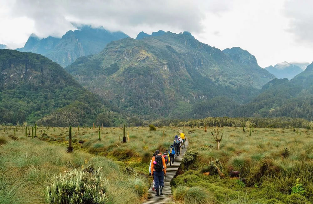
This forward position is the sole reason trekkers recognize it as a portal peak. The Rwenzori’s six major glaciated massifs: Stanley, Speke, Baker, Emin, Gessi, and Luigi di Savoia, sit deep in the interior of the range and are usually wrapped in cloud by mid-morning. The Rwenzori Portal Peaks, being closer to the plains and slightly detached from that interior weather system, are visible on clear mornings from Kasese town, from the road north to Fort Portal, and even from parts of Queen Elizabeth National Park to the east. They are, quite simply, the part of the Rwenzori that the outside world actually gets to look at.
Are the Portal Peaks One of the Six Major Rwenzori Massifs?
No, and this is worth stating clearly because the two groups are often confused in casual trip research. The six major Rwenzori Mountains, Mount Stanley (5,109 m), Mount Speke (4,890 m), Mount Baker (4,843 m), Mount Emin (4,798 m), Mount Gessi (4,715 m), and Mount Luigi di Savoia (4,627 m) m), form the glaciated, high-altitude core of the range and carry Africa’s third-highest point, Margherita Peak. The Portal Peaks are a separate, outlying group: lower, unglaciated, and positioned well forward of that core. Think of the six massifs as the Rwenzori’s cathedral and the Portal Peaks as the gatehouse you pass through to reach it, smaller in scale but genuinely part of the same mountain system and, for many first-time trekkers, no less memorable.
Why Are They Called the Portal Peaks?
The name is descriptive rather than mythological. Positioned at the very entrance to the Rwenzori Mountains along the Central Circuit Trail, the cluster is the first significant high ground that trekkers walk beneath on their way up from Nyakalengija and the first that lowland communities have watched, framed, and referenced for generations. Early European travelers writing about Rwenzori expeditions in the late nineteenth and early twentieth centuries consistently noted this same sensation: that a person walking toward the mountain passes beneath a row of forward peaks before the true scale of the Rwenzori Mountains range reveals itself. That threshold feeling, of passing through a gateway into something larger, is what gave the peaks their working name among guides and, eventually, in park literature.
The Bakonzo people, the indigenous community of the Rwenzori foothills and the source of virtually every guide and porter working on the mountain today, know these summits individually by their own names, which is why you will hear Kinyangoma, Kalongo, and Kalinda spoken specifically rather than the peaks being referred to only as a group. Our guides, who are Bakonzo themselves, will point out each summit by name as the cloud allows, and that local knowledge, not a brochure description, is the most authentic answer to why these mountains matter.
How High Are the Portal Peaks?
Elevation figures for the individual Portal Peaks vary somewhat between sources, which is not unusual for a range surveyed piecemeal over more than a century of expeditions. The cluster as a whole is most consistently cited around 4,391 meters, with Kinyangoma, the most prominent summit viewed from Nyabitaba and the Kasese lowlands, reaching approximately 4,627 meters in the figures used by several Rwenzori operators and guides. Kalongo and Kalinda are the central and eastern summits of the named trio, respectively; published elevation data for these two specific points is thin and inconsistent enough that we prefer to give you an honest range, roughly 4,000 to 4,500 meters, rather than a false-precision figure. Kuhuma and Rutara, the two summits our own 6-day Portal Peaks Rwenzori trekking itinerary is built around, are described on the ground by the guides who take trekkers up them every season as the highest and middle peaks of that closer pair, comfortably above 4,000 meters, reached without ropes or ice tools, and offering a full high-altitude Rwenzori experience in miniature.
For context: every figure in this cluster is lower than Margherita Peak’s 5,109 meters but higher than the summit of most European trekking peaks outside the high Alps. These are genuine mountains, not foothills, and they should be respected and prepared for as such.
Quick-Reference Table: The Portal Peaks and Their Trekking Access
Peak | Approx. Elevation | Position in Cluster | Difficulty | Trekking Access |
Kinyangoma | ~4,627 m (sources vary) | Highest and most prominent, viewed from Kasese/Nyabitaba | Strenuous, exposed scrambling | Viewed and approached via the Central Circuit Trail, Nyabitaba onward |
Kalongo | ~4,000–4,100 m (unconfirmed) | Central peak of the cluster | Moderate | Central Circuit Trail approach |
Kalinda | ~4,300–4,500 m (unconfirmed) | The eastern peak faces the plains | Strenuous | Central Circuit Trail approach |
Kuhuma | Highest of the two dedicated summit targets | The northern summit of the pair climbed on our Portal Peaks itinerary | Moderate, non-technical | |
Rutara | The middle-elevation summit of the pair | Sits between Kuhuma and the lower approach ridges | Moderate, non-technical |
Figures above reflect the ranges most consistently cited by Rwenzori guides and operators. Where independent survey data is thin, as with Kalongo and Kalinda, we have said so rather than presenting an invented precision. Ask your guide on the day for the most current park-registered figures.
Can You Climb the Portal Peaks?
Yes, the Portal Peaks can be trekked or hiked or climbed. Although the Portal Peaks are frequently written about only as scenery, a photogenic foreground to the real mountains behind them, the true fact is that Kuhuma and Rutara are legitimate, reachable summits in their own right. No glacier travel, crampons, ice axe, or rope work is required for either. You will need solid cardiovascular fitness, appropriate wet-weather gear, and a guide’s judgement on summit-day conditions, since the final approach involves steep, sometimes exposed rock scrambling that rewards balance and calm footwork rather than technical climbing skill.
Kinyangoma, Kalinda, and to some extent Kalongo are viewed and admired primarily from the trail rather than summited as part of standard commercial itineraries; their approaches are longer, less established, and better suited to independent mountaineering parties working with our guides on a bespoke basis than to a standard beginner schedule. If reaching one of these three named summits specifically is your ambition, tell us when you inquire, and we will build a custom itinerary around it.
Which Trekking Route Reaches the Portal Peaks?
Every standard approach to the Portal Peaks uses the Central Circuit Trail, starting at the Uganda Wildlife Authority park gate at Nyakalengija, roughly 22 kilometers north of Kasese town. This is the same trailhead used for the classic multi-day treks toward Margherita Peak, which is precisely why the Portal Peaks work so well both as a standalone objective and as the opening chapter of a longer summit expedition.
Our 6-Day Rwenzori Portal Peaks Trek
This is our purpose-built itinerary for trekkers who want a complete, genuine high-altitude Rwenzori experience without the technical demands or extended time commitment of a full Margherita Peak climb. Over six days on the Central Circuit Trail, the route climbs through the mountain’s forest and bamboo zones to the heather moorland before a dedicated summit push on Rutara, the middle peak, and Kuhuma, the highest of the pair. It is the itinerary we recommend most often to first-time Rwenzori trekkers and to families with capable older teenagers who want an authentic summit day without committing to a two-week expedition.
As Part of a Longer Central Circuit or Margherita Expedition
Trekkers heading further into the range, toward Margherita Peak on our 7- Day Rwenzori Trekking Central Circuit Margherita Trek, 8-day Rwenzori trek to Margherita Peak, or multi-peak itineraries, pass beneath and alongside the Portal Peaks cluster on the early approach days out of Nyakalengija and Nyabitaba. Building in time to properly view, photograph, and, where feasible, approach the named peaks on your way through is a straightforward addition we can make to your custom itinerary; it costs you little in schedule and adds real texture to the early days of a longer trek, when your body is still acclimatizing and a shorter objective day is genuinely useful.
How Difficult Is the Trek?
Honestly, the trek is moderately difficult and considerably easier than a Margherita Peak summit push, but it should not be underestimated. The six-day Portal Peaks itinerary is built for fit adults without prior high-altitude experience, provided that fitness is genuine rather than aspirational. If you can comfortably hike six to eight hours across consecutive days on uneven terrain, carrying a light daypack, you have the physical foundation this trek requires.
The Physical Challenge: Mud, Steep Climbs, Altitude, and Endurance
The Rwenzori has a reputation among East African mountains for a specific combination of physical demands, and the Portal Peaks approach shares in all of them. Mud is the defining terrain condition; the range’s ancient crystalline rock and dense vegetation create a spongy, waterlogged trail surface for much of the ascent through the forest and bamboo zones, regardless of season. Steep climbs follow, particularly on the ridge sections above Nyabitaba and on the final approach to the summit day, where the gradient becomes sustained and the footing rockier and more exposed. Altitude becomes a genuine factor above roughly 3,500 meters; even trekkers with strong lowland fitness can feel the thinner air on the final push, which is why our itinerary is paced to allow gradual acclimatization rather than rushing the ascent. Exposure on the rockier upper sections demands careful, unhurried foot placement rather than technical climbing skill. Weather can change within the same afternoon, turning a warm, clear morning into cold, driving rain by early afternoon, so a trekker’s gear discipline matters as much as their fitness. And endurance—the accumulated effect of consecutive long days on imperfect terrain— is ultimately what separates a comfortable Portal Peaks trek from a miserable one. We tell every guest the same thing before they book: train your legs and your cardiovascular base in the months beforehand, and the mountain will feel demanding but achievable rather than punishing.
Weather and Climate on the Portal Peaks
The Rwenzori generates much of its weather, and the Portal Peaks, positioned at the range’s windward edge, experience these effects in concentrated form. Rainfall is heavy and frequent throughout the year, with true dry-season relief limited to two windows rather than a single settled season. Temperatures swing dramatically by altitude and time of day, warm and humid in the lower forest zone; dropping close to freezing overnight above 3,500 meters; and colder still in wind-chill terms on an exposed summit morning. Fog builds reliably through the late morning as moisture rises off the forest canopy and condenses against the higher slopes, which is precisely why summit attempts on Kuhuma and Rutara begin before dawn, when the air is at its clearest. Wind on the exposed heather moorland and rocky upper approaches can be sharp and sustained, adding a real chill factor even when the temperature reading alone would suggest mild conditions. Seasonal variation is meaningful but should not be overstated: even in the better dry windows, waterproof layers are a mandatory daily kit, not an occasional precaution.
When Is the Best Time to Visit or Climb the Portal Peaks?
The two dry-season windows, roughly mid-December through late February and June through August, offer the most reliable trail conditions and the best odds of clear summit-morning views across the wider massif. Within those windows, early mornings consistently offer the clearest visibility before the daily cloud build-up, so summit pushes are always scheduled for first light. Trekking outside these windows, in the March–May or October–November wet season, is possible with the right gear and a realistic expectation of consistently wet trail conditions and reduced summit visibility; some experienced trekkers genuinely prefer this period for its lush vegetation, dramatic cloud formations, and near-total absence of other groups on the trail. If photography and summit views are your priority, book within the dry windows; if solitude and atmosphere matter more to you than guaranteed visibility, the wet season has its rewards.
Wildlife and Vegetation Around the Portal Peaks
The approach to the Portal Peaks moves through several of the Rwenzori’s distinct ecological zones in a single trek, which is one of the route’s genuine pleasures. The lower montane forest holds black-and-white colobus and blue monkeys, and, if you are fortunate, the calls of chimpanzees carry across the valley. Birders should watch closely for the Rwenzori turaco, a flash of crimson and green through the canopy that is one of the range’s signature sightings, alongside a wide variety of forest bird species.

The three-horned chameleon, endemic to the Rwenzori, is another highlight for guests with a naturalist’s eye. As the trail climbs into bamboo and then heather moorland, the vegetation itself becomes the spectacle: giant lobelias and giant heathers, draped in old man’s beard moss, create a landscape that looks genuinely prehistoric and unlike anything most trekkers have encountered on any other mountain.
Best Viewpoints and What You See from the Portal Peaks
On a clear morning from the higher points of the Portal Peaks cluster, hikers can see a view that tells an entire ecological and geological story in both directions. Looking south and west, the interior massif, Stanley, Speke, Baker, and, on the clearest days, Emin, Gessi, and Luigi di Savoia further along the range, rise in successive ridgelines, its glaciated summits catching early light before the daily cloud cover builds. Looking north and east, the Kasese lowlands spread out toward Lake George and the plains of Queen Elizabeth National Park, with the Rift Valley escarpment visible in the distance on exceptional days. Few single viewpoints on the African continent let you look, in one turn, from tropical forest and Bakonzo farmland below to genuine equatorial ice above, and that compression of an entire mountain ecosystem into one panorama is, for most of our guests, the single most memorable moment of the trek.
What Makes the Portal Peaks Special?
Their value lies precisely in their accessibility relative to the rest of the range. The Rwenzori as a whole remains one of Africa’s least-visited major mountain systems, receiving a small fraction of the trekkers that Kilimanjaro sees each year, and the Portal Peaks compress much of what makes the wider range extraordinary, dramatic geology, layered vegetation zones, genuine high-altitude achievement, and Bakonzo cultural depth into a shorter, less committing trek. For a solo traveler testing their appetite for high-altitude hiking; a couple wanting a shared achievement without a two-week absence from work; a family with capable teenagers ready for their first real mountain; or a group training before a bigger objective, the Portal Peaks offer a complete, honest mountain experience rather than a diluted preview of one.
Trekking to the Portal Peaks: Route, Duration, and What to Expect
Our six-day itinerary begins and ends at Nyakalengija, at roughly 1,640 metres in the Kasese District foothills, and follows the established Central Circuit Trail through the mountain’s vegetation zones before a dedicated summit day on Rutara and Kuhuma.
Day-by-Day: The 6-Day Portal Peaks Trek
Day 1: Nyakalengija to Nyabitaba Camp (approx. 2,650 m).
Your private guide meets you at the park headquarters for registration and briefing before the trail begins through community farmland and forest, following the Mubuku River. The gradual climb through montane forest is where most guests hear their first Rwenzori turaco and where the Portal Peaks come into view directly ahead, framing the day’s destination. Nyabitaba’s hut sits on a ridge with an open outlook toward the peaks, making it a genuinely dramatic first-night position, and dinner here is often eaten while watching the last light catch the summits above.
Day 2: Nyabitaba to John Matte Camp (approx. 3,505 m).
A longer day through denser forest and bamboo, with the trail steepening as you gain the ridge above the Bujuku valley. Vegetation shifts noticeably as you climb, from a tall forest canopy to a lower, denser bamboo corridor, and the first heather appears near camp. John Matte sits at the edge of the moorland zone, with the river running close by, making it a good spot to rest before the approach day.
Day 3: Approach to High Camp (Elena).
The trail moves fully into heather moorland and afro-alpine terrain, with giant lobelias appearing in increasing numbers and the ground becoming characteristically wet underfoot. This is a shorter, deliberately paced day, positioning your group for an early departure on summit morning while allowing your body more time to adjust to the altitude.
Day 4: Summit Day: Rutara and Kuhuma.
An early, pre-dawn start gives the best chance of clear conditions before the daily cloud builds. The route to Rutara, the middle peak, and on to Kuhuma, the highest of the pair, follows steep but non-technical rocky terrain, with your guide assessing footing and pace throughout. The summit reward, on a clear morning, is the full panorama described above, the inner massif to one side, and Uganda’s plains to the other.
Days 5 and 6: Descent to Nyakalengija.
The return retraces the ascent route, moving faster and offering a different perspective on terrain you climbed in the opposite direction days earlier. Knees and quads do the harder work on the way down; your porters and guide will set a pace that respects both your fitness and the trail’s often slick conditions.
Elevation Gain, Terrain, and Camps Summary
Across the six days, the trek gains roughly 2,500 meters of net elevation from Nyakalengija to the Kuhuma summit, spread across established huts at Nyabitaba and John Matte and a higher wilderness camp positioned for the summit push. The terrain moves progressively from farmland and forest to bamboo to heather moorland to rocky, exposed high ground, a genuine cross-section of everything the wider Rwenzori has to offer, in a fraction of the time a full Margherita expedition requires.
What’s Included and What’s Excluded
Every Rwenzori Trekking Expeditions itinerary is built so that you don’t have to arrange anything essential piecemeal once you’re on the ground. Your trek includes national park entrance fees, hut and camping fees payable to the Uganda Wildlife Authority, the services of your private guide and porters throughout, all meals on the mountain, and the use of standard rubber trekking boots where needed. What we ask you to arrange yourself is straightforward: international and domestic flights, Uganda visa costs, personal travel insurance, tips for your guide and porter team, and any pre- or post-trek accommodation in Kasese or Kampala.
Included: Park entry and hut fees · private guide and porter team · all on-mountain meals · rubber boot hire where required · pre-trek briefing and UWA registration · a contribution to Bakonzo community development from every booking.
Excluded: International and domestic flights · Uganda visa · travel and medical insurance · guide and porter tips · accommodation before and after the trek · personal trekking gear such as boots, waterproofs, and thermal layers.
What Does It Cost to Climb the Rwenzori Portal Peaks?
Pricing for the six-day Portal Peaks Trek depends on group size, season, and any add-ons such as gorilla or chimpanzee tracking combined into the same trip; smaller private groups and solo trekkers pay a higher per-person rate than larger shared groups, simply because fixed park and staffing costs are spread across fewer people. For a current, itemized quote based on your travel dates and group composition, reach out to our trekking team directly; we would rather give you an honest, tailored figure than a generic headline price that doesn’t reflect your actual trip.
What to Carry: Gear for the Portal Peaks and the Wider Rwenzori
The Rwenzori’s weather is genuinely unlike most mountains trekkers will have encountered before, and packing for it properly makes the difference between an uncomfortable trek and an enjoyable one. At minimum, bring a full waterproof shell jacket and trousers, worn daily regardless of the morning’s appearance; warm thermal base layers and a mid-layer fleece for camp and summit-day mornings; gloves and a warm hat for altitudes above 3,500 meters; and sturdy, broken-in trekking boots, ideally with a rubber gaiter or overboot given the persistent mud on the lower trail. Rubber wellington-style boots are available to rent locally and are genuinely useful on the wettest lower sections, though most trekkers prefer proper ankle-supporting boots for the rockier summit-day terrain. The essential list includes a four-season sleeping bag rated comfortably below freezing, a headtorch for the pre-dawn summit start, and trekking poles for the steeper descent sections.
How to Get to the Rwenzori Mountains
Kasese, the gateway town for the Central Circuit Trail, sits roughly 420 kilometers west of Kampala, a road journey of five to six hours on the main western highway, or a domestic flight of around an hour from Entebbe International Airport to Kasese airstrip. From Kasese, Nyakalengija and the park headquarters are a further 22 kilometers, roughly half an hour by road. We arrange private transfers throughout, so your journey from arrival in Uganda to the trailhead is handled without you needing to coordinate public transport or unfamiliar logistics.
Beyond the Portal Peaks: Attractions in the Rwenzori Region
Many of our guests combine a Portal Peaks trek with the wider attractions of western Uganda rather than treating it as an isolated trip. Queen Elizabeth National Park, a short drive east of Kasese, offers boat safaris on the Kazinga Channel and a genuine chance of tree-climbing lions. Kibale Forest, further north, is one of the best places on the continent for chimpanzee tracking. And Bwindi Impenetrable Forest National Park, reachable in a longer combined itinerary, offers gorilla trekking that pairs naturally with a Rwenzori summit trip to create a complete western Uganda adventure, mountains, primates, and open savannah wildlife in a single, well-sequenced journey that we can design around whatever time you have available.
Ready When You Are
Kinyangoma, Kalongo, Kalinda, Kuhuma, and Rutara have stood at the edge of the Rwenzori longer than any of us have guided here, and they will still be there long after we retire. What changes is whether you decide to see them properly, not from the roadside in Kasese but from their summits, with the six great peaks of the interior massif spread out behind you and the Ugandan plains falling away below.
When you trek with us, every detail,your private guide, your porter team, your transfers from Entebbe or Kasese, and your meals and camps on the mountain, is arranged before you arrive, so the only decision left on the day is which direction to look first from the summit. If the Portal Peaks are your goal, or the opening days of a longer Margherita expedition, we would be glad to discuss it with you and build the itinerary around your dates, fitness, and ambition.
Get in touch with our trekking team to start planning your Rwenzori Portal Peaks trek.