Location Of (Where Is) Mount Baker?
Mount Baker sits in the central Rwenzori massif, immediately west-southwest of Mount Stanley and just south of Mount Speke, the three together forming a triangular wall of high peaks that encloses the glacially carved upper Bujuku Valley. The mountain lies almost on the international boundary, roughly 2.8 kilometers from the Democratic Republic of the Congo, and is visible on a clear day from Bamwanjara Pass on the Kilembe Trail to the south, as well as from the Kitandara Lakes directly beneath its southern flank.

The standard approach is via the Central Circuit Trail, the historic eastern route into the range, which starts at the Nyakalengija trailhead near Ibanda in Kasese District. Trekkers climb through Nyabitaba, John Matte, and Bujuku camps, cross the Bujuku Valley beneath Mount Speke, and either continue over Scott Elliot Pass toward Elena Hut and Mount Stanley or drop to the Kitandara Lakes directly below Mount Baker’s southern face. From Kitandara, the trail toward Freshfield Pass provides the standard access point for a Mount Baker summit attempt, while the same pass also carries the Central Circuit trail onward toward Guy Yeoman Camp and, eventually, back to the trailhead, making Baker a natural link between the Stanley massif and the trail’s return leg rather than an out-and-back detour.
A detailed route map, GPS coordinates for each camp, and a full elevation profile for the Central Circuit trail approach to Mount Baker are maintained on our Central Circuit Trail page, linked at the end of this guide.
Why Is Mount Baker Important?
Mount Baker’s significance extends well beyond its elevation. It is one of only a few African peaks over 4,800 meters, and being part of Rwenzori Mountains National Park connects it to the park’s UNESCO World Heritage status, granted in 1994 for the range’s outstanding natural beauty, its unbroken sequence of five vegetation zones, and its exceptional biodiversity. Geologically, Mount Baker is a textbook example of fault-block mountain building: unlike the volcanic cones of Kilimanjaro and Mount Kenya, it was pushed up as a rigid block of ancient crystalline rock along the faults of the Albertine Rift, and its jagged, glacially sculpted ridgelines are a direct visual record of that violent tectonic history.
For trekkers, Mount Baker offers a distinct experience within the wider Rwenzori system: alpine biodiversity across five vegetation zones on the approach, some of the most scenic ridgeline panoramas in the range from its upper slopes, and, because its glaciers have now retreated entirely, the opportunity for a genuine high-altitude scramble to a major African summit without the technical glacier travel required on neighboring Mount Stanley. That combination makes it both a serious objective in its own right and a natural, complementary addition to a multi-peak Rwenzori expedition.
The Peaks of Mount Baker
Mount Baker is not a single summit but a cluster of rocky peaks arranged around a central ridge system, most of them named after the explorers and expedition members who first mapped the mountain in 1906.
Peak | Elevation | Notes |
Edward Peak | 4,844 m | The true, highest summit of Mount Baker is officially recognized as the mountain’s high point. The Duke of the Abruzzi’s expedition first reached the summit on 10 June 1906. |
Semper Peak | ≈4,794–4,795 m | The second-highest point on the massif, it takes its name from an alternative name that Franz Stuhlmann applied to the whole mountain in 1891. |
Wollaston Peak | ≈4,626 m | Named for Alexander F. R. Wollaston, whose 1906 English expedition reached a subsidiary point on the mountain earlier that year. |
Moore Peak | ≈4,623–4,624 m | A further named summit on the Baker Massif’s ridge system. |
Grauer Rock | ≈4,484 m | The mountain is named after Rudolf Grauer, the Austrian mountaineer who, with two British missionaries, first reached the mountain’s ridge line in January 1906, ahead of the summit ascent later that year. |
Edward Peak is the only one of these summits officially recognized as Mount Baker’s true high point; the others are informally but consistently referenced subsidiary peaks along the same ridge system, and their exact elevations vary slightly between older surveys and more recent GPS-verified measurements.
History of Mount Baker
Long before European expeditions reached the Rwenzori, the mountain was known to the Bakonzo people, who inhabit the range’s foothills, as Kiyanja, a name still used locally today. The Bakonzo hold deep traditional and spiritual connections to the Rwenzori’s high peaks, a relationship that predates and continues alongside the mountain’s colonial-era European naming.
The mountain’s European name honors Sir Samuel Baker (1821–1893), the British explorer who, together with his wife Florence, became the first European to see Lake Albert in 1864 while searching for the source of the Nile and who reported sighting distant mountainous terrain to the south of the lake. The mountain itself was first sighted by a European in June 1891, when the German explorer Franz Stuhlmann observed it during his expedition into the Rwenzori and recorded two alternative names for it, “Semper” and “Ngemwimbi,” the former surviving today as the name of one of the mountain’s subsidiary peaks.
The mountain’s climbing history unfolded across a single remarkable year. In January 1906, the Austrian mountaineer Rudolf Grauer, accompanied by two British missionaries, H. E. Maddox and H. W. Tegart, reached the mountain’s ridge line for the first time. Between February and April of that same year, an English expedition led by Alexander F. R. Wollaston, together with A. B. Woosnam and M. Carruthers, reached the same rocky point independently. The true summit, Edward Peak, was finally reached on 10 June 1906 by the Italian expedition of Prince Luigi Amedeo, Duke of the Abruzzi, accompanied by his lead guides Joseph Petigax, César Ollier, and Josef Brocherel, the same extraordinary expedition that, within a matter of weeks, completed the first ascents of all six of the Rwenzori’s principal glaciated massifs, permanently establishing the range on the map of world mountaineering.
Geology Of Mount Baker
Mount Baker owes its existence to tectonic uplift rather than volcanic activity. The Rwenzori range as a whole is a horst, a block of the Earth’s crust thrust upward between parallel fault systems, formed roughly three million years ago during the Pliocene as the Albertine branch of the East African Rift pulled the surrounding crust apart and the Rwenzori block rose between the resulting faults. This uplift is what makes the range the highest non-volcanic mountains in Africa, and the faulting that produced it is still active today, with the region recording regular low-magnitude earthquakes and the mountains themselves still rising at rates measured in fractions of a millimeter per year.
The rock exposed on Mount Baker’s upper slopes and summit ridges is part of the Rwenzori’s ancient Precambrian basement complex, comprising gneiss, amphibolite, granite, and quartzite dated to roughly two billion years old, making it some of the oldest exposed rock anywhere in East Africa. Superimposed on this ancient bedrock is a much younger layer of glacial sculpting: the sharp arêtes, deep cirques, and polished rock faces trekkers encounter on the approach to Edward Peak were carved by the far more extensive ice sheets that covered the mountain during past glacial maxima, and the U-shaped Bujuku Valley below is a direct legacy of that older, larger glaciation. Understanding this geological layering of ancient rift-uplifted basement rock, reshaped by relatively recent glacial erosion, helps explain both the mountain’s jagged profile and the loose, frost-shattered rock trekkers navigate on the final scramble to the summit.
Glaciers and Alpine Landscape Of Mount Baker
Mount Baker once carried its small glacier system, part of the wider ice cover that, at the start of the twentieth century, extended across six of the Rwenzori’s principal peaks. Along with Mount Speke, Mount Baker’s glaciers have now retreated completely; comparative photographic surveys, including fieldwork by glaciologist and photographer Klaus Thymann around 2020, confirmed the absence of any remaining glacier ice on both mountains, consistent with the wider pattern of accelerating tropical glacier loss recorded across the Rwenzori. Today, only Mount Stanley retains glacier ice, concentrated on its Stanley Plateau immediately below Margherita Peak, and even that remnant is retreating rapidly.
What remains on Mount Baker is the landscape that glaciation left behind, rather than the ice itself: sharply carved ridgelines and cirques, moraine deposits marking the historical extent of vanished ice, and alpine tarns fed by the Rwenzori’s exceptionally heavy rainfall in the valleys below. This means that trekkers today experience Mount Baker as a glacially sculpted but currently ice-free mountain, a landscape shaped by ice rather than one still covered by it, and a useful, tangible illustration of the broader glacier retreat documented across the range.
For a full, dedicated explanation of the science behind this retreat, see our companion guide, Why the Rwenzori Glaciers Are Disappearing, linked at the end of this page.
Vegetation Zones of Mount Baker
The approach to Mount Baker via the Central Circuit Trail passes through the same remarkable ecological transect that defines UNESCO’s recognition of the wider park, compressed into a single multi-day climb.

Montane Forest (roughly 1,650m–2,500m)
Dense Afro-montane forest cloaks the lower trail from the Nyakalengija trailhead to Nyabitaba, rich with birdsong, primates, and the sound of the Mubuku River below.
Bamboo Zone (roughly 2,500m–3,000m)
A steep corridor of tall bamboo forest, often muddy underfoot, forms the transition between the lower forest and the higher heather belt on the approach toward John Matte Camp.
Heather Zone (roughly 3,000m–3,800m)
Giant heather trees draped in pale lichen, thick moss, and frequent mist define this atmospheric middle zone, spanning much of the Bujuku Valley approach.
Afro-Alpine Moorland (roughly 3,800m–4,500m)
Boggy tussock grassland studded with giant lobelia and giant groundsel surrounds Bujuku and Kitandara camps and stretches up toward Freshfield Pass on the direct approach to Mount Baker.
High-Altitude Rocky Terrain (4,500m and above)
Above the moorland, vegetation thins rapidly to bare rock, loose scree, and frost-shattered ridgelines as the trail climbs toward Baker’s summit peaks, where the final scramble to Edward Peak occurs almost entirely above the vegetation line.
Wildlife
Wildlife sightings on the Mount Baker approach are concentrated in the lower forest zones, and trekkers should treat every encounter as a genuine, rewarding possibility rather than a guarantee; this is wild, undisturbed habitat, not a managed viewing circuit.
Primates
Black-and-white colobus and blue monkeys are regularly seen or heard in the forest between Nyakalengija and Nyabitaba, and wild chimpanzees are present in the lower valleys, more often heard calling at dawn and dusk than seen directly.
Albertine Rift Endemic Birds
The Rwenzori is part of the Albertine Rift, one of Africa’s richest areas for bird endemism, and the forest and heather zones along the approach provide real chances to see species found nowhere else, including the striking Rwenzori turaco.
Forest Mammals
Duiker species and, occasionally, signs of larger forest mammals are recorded in the lower montane forest, though sightings of these shyer species are considerably less common than primate or bird encounters.
Amphibians and Insects
The Rwenzori’s exceptional rainfall supports a rich, if less conspicuous, community of montane amphibians and invertebrates adapted to the range’s cool, wet forest and moorland habitats, of particular interest to trekkers with a naturalist’s eye.
Climbing Mount Baker
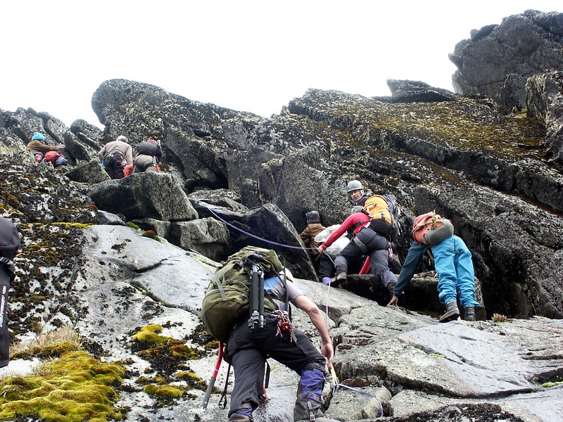
The standard route to Edward Peak follows the Central Circuit Trail to the Kitandara Lakes, directly beneath Mount Baker’s southern flank, before turning onto the mountain’s south ridge, the same line used on the first ascent in 1906 and still the accepted standard route today. From Kitandara, the trail climbs toward Freshfield Pass until the gradient levels out, then continues up open slopes past a series of small alpine ponds to a saddle just west of the main ridge line. From this saddle, the route follows the ridge itself to the summit of Edward Peak, a final stretch of sustained scrambling over bare, frost-shattered rock that, since the disappearance of Baker’s glaciers, no longer requires crossing any snow or ice.
Most trekkers reach Mount Baker as part of a longer Central Circuit itinerary that also takes in Mount Stanley and Mount Speke, typically over eight to nine days in total, using the established camp sequence of Nyabitaba, John Matte, Bujuku, Elena, Kitandara, and Guy Yeoman. For trekkers who want to focus specifically on Baker, a dedicated five-day itinerary via Freshfield Pass is also available, cutting out the Stanley and Speke summit days while still crossing all five of the range’s vegetation zones. Total altitude gain from the Nyakalengija trailhead to Edward Peak exceeds 3,100 meters over the course of the trek, and the summit push itself typically takes around five hours up from high camp and three hours back down, depending on conditions and pace.
Difficulty and Fitness of Mount Baker
Mount Baker is graded challenging rather than extreme, but it should not be underestimated. The approach trail alone involves multiple long days at altitude over frequently muddy, root-strewn, and boggy terrain, and the final summit scramble to Edward Peak, while not technical roped climbing in the way Margherita Peak’s glacier crossing is, involves sustained exposure to loose rock, steep sections, and real consequences for a slip near the ridge. Good general cardiovascular fitness, prior experience hiking multiple consecutive long days with a daypack, and comfort with basic scrambling and exposure all significantly affect how the climb feels.
Altitude is the other major factor: Edward Peak’s 4,844 meters puts trekkers well into the range where acute mountain sickness becomes a genuine risk without proper acclimatization, and the multi-day approach via the Central Circuit trail is itself an important part of managing that risk gradually rather than rushing the ascent. Trail conditions can also change quickly, with the Rwenzori’s notoriously heavy rainfall turning sections of the moorland approach to deep mud with little warning, so realistic expectations about pace and daily distances matter as much as raw fitness.
Weather and Climate Of Mount Baker
The Rwenzori sits in one of the wettest corners of East Africa, with some high-altitude sites recording over 3,000 millimeters of rainfall annually, and Mount Baker’s approach shares fully in that weather pattern. Temperatures fall steadily with altitude, from warm, humid conditions in the lower forest to sub-zero nights at the higher camps and on the summit ridge itself, where wind chill can make conditions feel considerably colder than the air temperature alone would suggest. Cloud cover builds through the morning on most days, meaning the clearest views and safest conditions for the summit scramble are typically found in the early hours, before afternoon clouds and, frequently, rain or snow squalls move in, a daily pattern trekkers should plan around regardless of season.
Best Time to Climb Mount Baker
Mount Baker, like the rest of the Rwenzori, has two principal dry-season windows: mid-December to mid-February and June to August. Trail conditions on the boggy moorland approach are noticeably firmer in these months, and visibility on the exposed summit ridge tends to be better, particularly in the early morning. Outside these windows, particularly in the long rains of April and May, the approach trail becomes considerably muddier and stream crossings more demanding, though the vegetation is at its lushest and the trail correspondingly quieter. Photography of the ridge panoramas and alpine lakes is best attempted early in the day throughout the year, and wildlife activity in the lower forest zones is fairly consistent year-round rather than strongly seasonal. Whatever month is chosen, mountain weather here can change rapidly, and every itinerary should be planned with that unpredictability in mind rather than around a guaranteed clear-weather forecast.
Equipment Guide
Waterproof, well broken-in hiking boots with excellent ankle support are essential for the sustained, often muddy terrain between camps, and a solid pair of trekking poles significantly reduces strain on the steep, root-covered sections of the lower trail and the loose scree near the summit. Insulated layers, a warm mid-layer plus a down or synthetic jacket, are necessary for the cold camps and pre-dawn starts, paired with a fully waterproof, windproof outer shell given how quickly the Rwenzori’s weather can turn. Warm gloves and an insulated hat matter more here than many trekkers expect, given the wind chill on the exposed summit ridge, and a reliable headlamp with spare batteries is essential for the early starts typical of a summit day. A four-season sleeping bag suited to sub-zero camp temperatures and a comfortable daypack for personal items and layers complete the core kit list. Because the standard route to Edward Peak no longer crosses glacier ice, technical mountaineering equipment such as crampons and ice axes is not required for Mount Baker specifically, unlike the Margherita Peak route on Mount Stanley, though trekkers combining both summits on one expedition will still need that equipment for the Stanley leg.
Safety Of Mount Baker
Altitude sickness is the most significant risk on any Mount Baker climb, and the gradual, multi-day ascent profile of the Central Circuit Trail is itself the primary safeguard against it; trekkers should never be tempted to compress the itinerary to save time. Slippery trail conditions, particularly through the bamboo and moorland zones after rain, account for the majority of minor trekking injuries in the range, making trekking poles and careful footwork genuinely important rather than optional extras. Weather hazards, including sudden cloud, rain, or snow on the exposed summit ridge, are best managed by starting early, watching the sky closely, and being willing to turn back if conditions deteriorate.
Navigation on the upper mountain, particularly around the saddle and ridge sections near Edward Peak, is not straightforward without local knowledge, which is one of several reasons a qualified, experienced guide is not merely advisable but essential for any Mount Baker ascent; guides here also carry the emergency planning knowledge and communication arrangements that make a genuine difference if conditions or an injury require a change of plan.
Photography Guide Of Mount Baker
The clearest light for photographing Mount Baker’s ridgelines typically comes in the first hour or two after sunrise, before the day’s clouds begin to build, a pattern worth planning entire camp mornings around. The Kitandara Lakes, directly beneath Baker’s southern face, offer some of the most striking reflective panoramas in the range, particularly on still mornings, while the saddle just west of the summit ridge provides sweeping views across to Mount Stanley’s glaciated Stanley Plateau and, on exceptionally clear days, into the Congo Basin to the west. The Afro-alpine moorland around Bujuku and Kitandara, with its giant lobelia and groundsel silhouetted against the ridgelines, is best for wide-angle landscape shots, while the forest zones lower down are better for patient, telephoto work with primates and birds, where sightings reward those willing to move slowly and quietly.
Conservation Of Mount Baker
Mount Baker’s protection is bound up with that of the wider Rwenzori Mountains National Park, inscribed as a UNESCO World Heritage Site in 1994 in recognition of its outstanding natural beauty, its complete sequence of vegetation zones, and its exceptional biodiversity. The Uganda Wildlife Authority manages the park day to day, including permitting, ranger patrols, trail and hut maintenance, and rescue coordination across the Central Circuit and its side routes to Baker, Stanley, and Speke. Climate change remains the dominant conservation concern for the range’s higher elevations specifically: Mount Baker’s own glaciers are already gone, and the same warming trend continues to affect Mount Stanley’s remaining ice, the alpine moorland’s water balance, and the timing of seasonal patterns that both wildlife and trekking operations depend on.
Responsible trekking practice directly supports this conservation effort. Staying on established trails through the fragile moorland and heather zones limits erosion in terrain that recovers slowly at this altitude; packing out all waste protects both the immediate trail corridor and the water sources below; and booking with operators who employ and fairly compensate local Bakonzo guides, porters, and cooks ensures that the economic benefit of Mount Baker’s visitors flows directly back into the communities who have safeguarded this landscape for generations.
Comparison with Other Major Rwenzori Peaks
Mountain | Height | Distinguishing Feature |
Mount Stanley | 5,109 m | Africa’s third-highest mountain (or fourth, on strict prominence rankings), home to Margherita Peak and the range’s last remaining glacier ice. |
Mount Speke | ≈4,890 m | Africa’s fourth-highest mountain (or fifth by strict rankings) has striking alpine ridgelines above the Bujuku Valley, now entirely ice-free. |
Mount Baker | ≈4,844 m | Africa’s fifth-highest mountain (or sixth on strict rankings), known for Edward Peak, dramatic sculpted ridgelines, and scenic multi-peak expeditions. |
The three massifs are close enough together and connected by the Central Circuit Trail that experienced trekkers often combine two or all three into a single extended expedition, since a Baker or Speke ascent shares most of its approach trail and camp network with a Margherita Peak attempt on Mount Stanley.