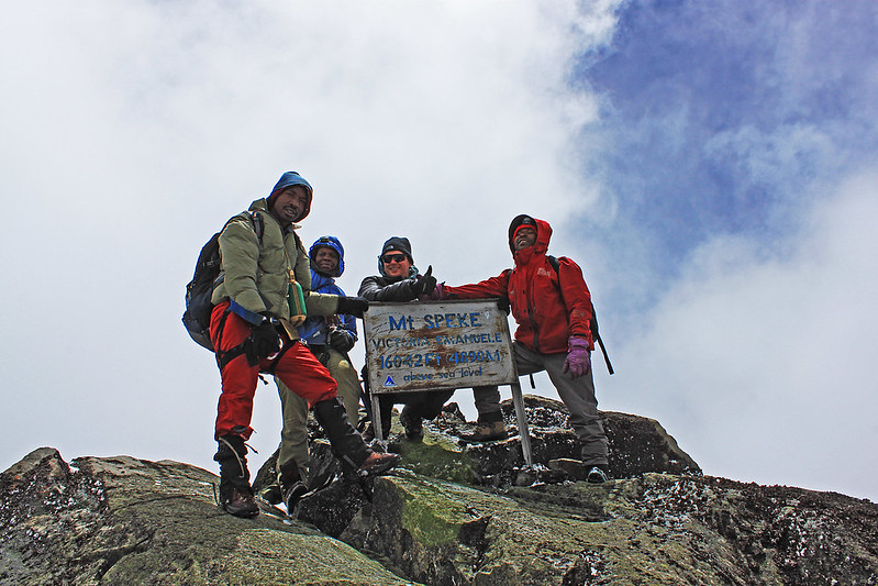
Mount Speke is the second-highest peak (Vittorio Emanuele Peak at 4,890 m) of the Rwenzori Mountains in Rwenzori Mountains National Park and the fourth-highest in Africa. Mount Speke is one of the six great glaciated massifs of the Rwenzori Mountains, rising to approximately 4,890 meters at its highest point, Vittorio Emanuele Peak, and standing as Africa’s fourth-highest independent peak, behind only Kilimanjaro, Mount Kenya, and the Rwenzori’s own Mount Stanley.
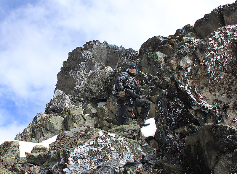 Mount Speke lies entirely within Rwenzori Mountains National Park, a UNESCO World Heritage Site on the Uganda–DRC border, and forms one corner of the dramatic triangle of peaks, alongside Mount Stanley and Mount Baker, that encloses the glacial Bujuku Valley.
Named after the nineteenth-century explorer John Hanning Speke, the mountain is known among experienced trekkers for its knife-edged ridgelines, its exceptional alpine scenery, and a summit day that is technically serious without demanding the roped glacier travel required on Margherita Peak. For travelers who want to experience the true scale and drama of the Rwenzori, including sweeping views of Mount Stanley’s ice cap and the Congo basin, without the crowds, permits, and glacier logistics needed for the range’s highest summit, Mount Speke has become one of East Africa’s most rewarding and relatively overlooked high-alpine objectives.
All mountains in this range are characterized by several craggy peaks. The elevations of Mount Speke’s peaks are as follows: Vittorio Emanuele at 4,890 meters (16,040 feet), Ensonga at 4,865 meters (15,961 feet), Johnston at 4,834 meters (15,860 feet), and Trident at 4,572 meters (15,000 feet), above sea level. The names originated from an Italian royal family, although they required approval from the government of the British Protectorate of Uganda, which ruled at the time.
Quick Facts About Mount Speke
Mountain | Mount Speke |
Highest Summit | Vittorio Emanuele Peak |
Elevation | 4,890 m (16,040 ft) — verify against current UWA/survey data before publication |
Rank in Africa | Africa’s fourth-highest independent peak |
Rank in the Rwenzori | Second-highest massif in the range, after Mount Stanley |
Country | Uganda |
Mountain Range | Rwenzori Mountains (Albertine Rift) |
National Park | Rwenzori Mountains National Park |
UNESCO World Heritage Site | Yes (inscribed 1994) |
Mountain Type | Fault-block mountain (horst) |
Named After | John Hanning Speke, explorer of the Nile’s sources |
First Ascent | 1906, Duke of the Abruzzi expedition |
Trek Difficulty | Challenging — high altitude, exposed scrambling near the summit |
Best Access | Central Circuit Trail, via the Bujuku Valley |
Location: Where Is Mount Speke?
Mount Speke sits close to 0°24′N, 29°53′E, within the central massif cluster of the Rwenzori range, roughly 3.6 kilometers north-northeast of Mount Stanley and within sight of Mount Baker to the south. Together, these three massifs form a rough triangle enclosing the upper Bujuku Valley, one of the range’s most celebrated glacial landscapes and the site of Lake Bujuku, a glacially formed alpine lake ringed by giant lobelias and framed by all three peaks at once.
The standard approach to Mount Speke follows the Central Circuit Trail from the park headquarters at Nyakalengija, climbing steadily through the Mubuku Valley to Nyabitaba, then through bamboo and heather zones to John Matte Camp and onward into the Bujuku Valley itself. From Bujuku Camp, the route to Speke’s summit climbs via Stuhlmann’s Pass, at approximately 4,190 meters, before the final scramble to Vittorio Emanuele Peak. This approach places Mount Speke naturally within reach of trekkers already undertaking the Central Circuit trail, whether as a dedicated side-summit or as one leg of a broader multi-peak itinerary encompassing Mount Baker and Mount Stanley as well.
Why Is Mount Speke Important?
Mount Speke’s significance extends well beyond its ranking as Africa’s fourth-highest peak. Geologically, it is part of the same uplifted Precambrian fault block described in our companion Geology guide, meaning its rock, like that of Mount Stanley and Mount Baker, is ancient metamorphic basement material rather than volcanic stone, distinguishing it sharply from Kilimanjaro and Mount Kenya. Ecologically, the mountain forms part of one of the most important equatorial alpine ecosystems on Earth, hosting endemic Albertine Rift flora and fauna found in only a handful of other locations across the continent.
Scientifically, Mount Speke’s remaining ice, along with that of Mount Stanley and Mount Baker, is among the last equatorial glacier ice anywhere on the planet, making the mountain a genuine, if modest, contributor to the broader body of research on tropical glacier retreat discussed in our Climate Change and Glaciers coverage. And as part of Rwenzori Mountains National Park’s UNESCO World Heritage inscription, Mount Speke’s slopes fall directly within a landscape recognized for both outstanding natural beauty and outstanding biodiversity value, a designation that shapes how the mountain is managed, guided, and protected today.
The Peaks of Mount Speke
Like all of the Rwenzori’s principal massifs, Mount Speke is not a single summit but a ridge system of several named points, first mapped and named during the Duke of the Abruzzi’s 1906 expedition. The names given to Speke’s summits honored the Italian royal family of the era, a choice that nonetheless required the formal approval of the British Protectorate authorities then governing Uganda.
Summit | Elevation | Notes | Climbing Considerations |
Vittorio Emanuele | 4,890 m | Highest summit of Mount Speke; named for the King of Italy | Reached via Stuhlmann Pass; steep scrambling near the top, non-technical in dry conditions |
Ensonga | 4,865 m | Second-highest point on the massif | Rarely climbed independently; usually noted rather than summited on standard itineraries |
Johnston | 4,834 m | Named for explorer Sir Harry Johnston | A subsidiary summit along the same ridge system |
Trident | 4,572 m | Named for its three-pronged rock profile | The lowest of the four named summits, visible from the Bujuku Valley approach |
Of these four summits, Vittorio Emanuele Peak is the objective for virtually all guided ascents; the other three are typically viewed rather than climbed on standard itineraries, both because they add little to the experience for most trekkers and because established, safety-vetted routes exist only to the highest point.
History of Mount Speke
Long before any European expedition reached its slopes, Mount Speke, like the rest of the range, was known intimately to the Bakonzo people, who lived along the lower Rwenzori and possessed detailed practical knowledge of its valleys, weather, and terrain, and to the Baganda people of the surrounding lowlands, who could see the range’s snow-capped summits from a great distance and knew them by the name Gambaragara, loosely translated as ‘the mountains that hurt the eyes,’ a reference to the glare of sunlight on distant snow. Our History of the Rwenzori Mountains guide discusses this indigenous familiarity with the range in more depth.
The mountain’s European name commemorates John Hanning Speke, the British explorer who in 1862 identified the point where the Nile exits Lake Victoria, a central piece of evidence in the long nineteenth-century effort to resolve the river’s ancient, legendary source. Speke never saw the Rwenzori himself; the naming reflects his broader role in Nile-source exploration rather than any direct connection to the mountain. The peak was first climbed, and its individual summits first mapped and named, during Prince Luigi Amedeo of Savoy’s celebrated 1906 expedition, the same campaign that achieved the first ascent of Margherita Peak on Mount Stanley and comprehensively surveyed the range’s central massifs, discussed in full in our dedicated Rwenzori history and geology pages. In the decades since, Mount Speke has developed as a secondary but respected mountaineering objective within the Rwenzori, drawing steadily increasing numbers of trekkers as guiding standards, hut infrastructure, and route safety on the Central Circuit trail have matured.
Geology Of Mount Speke
Mount Speke shares the same geological origin as the rest of the Rwenzori: it is not a volcano but a segment of an ancient, uplifted fault block, made mostly of Precambrian metamorphic rock, gneiss, quartzite, and amphibolite, pushed to alpine heights by tectonic forces acting along the Albertine Rift over the past several million years. The mountain’s steep, knife-edged ridgelines and its exposed rock scrambles near the summit are a direct result of this exceptionally durable, resistant basement rock combined with periods of intense glacial erosion, which carved the deep, U-shaped profile of the surrounding Bujuku Valley and left behind the moraine ridges now visible along the approach.
Trekkers moving through the Bujuku Valley toward Speke’s summit cross clear evidence of this history first-hand: glacially polished rock surfaces, moraine terraces marking the former extent of much larger ice masses, and, near Stuhlmann’s Pass, exposed basement rock scoured bare by ice and weather alike. A fuller explanation of how this fault-block landscape formed is available in our dedicated Rwenzori Geology guide.
Glaciers and Alpine Environment of Mount Speke
Mount Speke was historically one of the range’s glaciated massifs, its upper slopes carrying permanent ice through the twentieth century. Like the rest of the Rwenzori’s glaciers, however, Speke’s ice has retreated dramatically over the past century, tracking the broader pattern documented across the range: from roughly 6.5 square kilometers of total glaciated area across the Rwenzori in 1906 to under 0.4 square kilometers by the early 2020s, with ice now surviving in meaningful quantity only on Mount Stanley and much smaller, rapidly diminishing remnants on Mount Speke and Mount Baker.
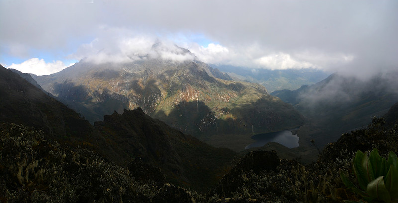
Trekkers attempting Mount Speke today should expect an alpine summit experience, rather than a strictly glaciated one: exposed rock, occasional patches of snow or old ice depending on the season and recent weather, and the cold, thin, highly changeable conditions typical of equatorial altitudes above 4,500 meters, rather than the sustained glacier travel required on Margherita Peak. This makes Speke, in practical terms, a somewhat more accessible summit day than Mount Stanley’s highest point, though still a serious undertaking by any ordinary hiking standard.
Vegetation Zones
The approach to Mount Speke passes through the same dramatic sequence of vegetation zones that defines the Rwenzori experience as a whole, compressed into a single multi-day trek. Between roughly 1,800 and 2,500 meters, the route climbs through dense montane forest, rich in birdlife and home to several primate species. Above this elevation, between approximately 2,500 and 3,000 meters, the trail enters a bamboo zone, giving way in turn to a heather zone, characterized by gnarled, moss-draped heather trees that lend the middle elevations of the Bujuku Valley an almost otherworldly, fog-bound atmosphere.
Beyond roughly 3,800 meters, the route emerges into the afro-alpine moorland for which the Rwenzori is best known internationally, dominated by giant lobelias and giant groundsels adapted to intense daytime sun and near-freezing nights. Finally, above approximately 4,300 meters, trekkers enter the high alpine environment proper: bare rock, sparse cushion plants, and, near the summit ridge, the cold, wind-scoured terrain typical of equatorial high-altitude peaks. You can read about this ecological transition in still greater detail in our dedicated Vegetation Zones guide.
Wildlife Of Mount Speke
Wildlife encounters on the approach to Mount Speke vary considerably by elevation and ecosystem. In the lower montane forest, trekkers may encounter blue monkeys and, less commonly, black-and-white colobus, alongside a rich diversity of forest birds, including the striking Rwenzori turaco. The Albertine Rift’s status as a global center of avian endemism is especially visible on this route, with species such as the Rwenzori double-collared sunbird and several other range-restricted birds recorded along the trail’s middle elevations, details covered further in our Wildlife Guide.

Higher up, in the heather and afro-alpine zones, wildlife becomes sparser but no less distinctive: chameleons adapted to cold montane conditions, a range of high-altitude amphibians found nowhere outside the Albertine Rift’s mountain ranges, and a variety of specialized alpine insects that pollinate the region’s giant lobelias. Small mammals such as duikers and occasionally hyrax may be glimpsed at the ecotones between vegetation zones, though, as throughout the Rwenzori, dense vegetation and steep terrain mean that most large mammal sightings are the exception rather than the rule on this route.
Trekking Routes to Mount Speke
Almost exclusively, trekkers reach Mount Speke via the Central Circuit Trail, which departs from the Rwenzori Mountains National Park headquarters at Nyakalengija. A typical itinerary allows five to seven days round-trip, following the route Nyabitaba, John Matte Camp, and Bujuku Camp, from which a dedicated summit day tackles Stuhlmann’s Pass and the final scramble to Vittorio Emanuele Peak, before retracing the route or continuing on to combine Speke with an ascent of Mount Baker or an attempt on Margherita Peak for those undertaking a full multi-peak expedition.
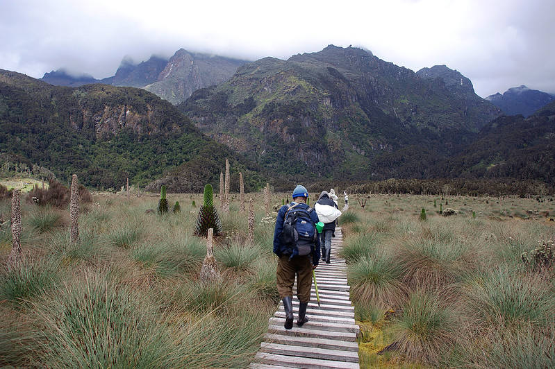
Acclimatization is key for a safe itinerary because the route gains significant altitude quickly; a good schedule includes rest days and a gradual ascent profile around Bujuku Camp, at about 3,960 meters, before the summit push. Nearby camps, including John Matte and Bujuku, serve both as acclimatization stops and as bases from which trekkers can appreciate close-up views of Mount Stanley and Mount Baker across the valley, making the Central Circuit a natural setting for multi-peak itineraries that combine two or more of the range’s principal summits in a single well-paced expedition, an option our guides plan regularly for experienced trekkers. Full day-by-day details are available in our Central Circuit Trail itinerary guide.
Difficulty and Fitness
Climbing Mount Speke demands solid trekking fitness, prior high-altitude experience or a carefully paced acclimatization schedule, and comfort with sustained scrambling on exposed rock. The route does not require roped glacier travel like that on Margherita Peak, but the final approach via Stuhlmann’s Pass and the summit ridge involves steep, sometimes exposed scrambling over wet or icy rock. These sections are non-technical in the mountaineering sense, but they are unforgiving of poor balance, fatigue, or inadequate footwear.
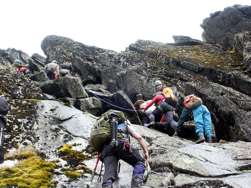
Beyond the summit day, the broader trek involves long hiking days, frequent and sometimes thigh-deep river crossings, notoriously boggy sections in the lower valley, and sustained steep gradients throughout. Altitude is a serious consideration throughout, with symptoms of altitude illness a real risk above 4,000 meters regardless of a trekker’s general fitness, which is why we structure every Speke itinerary around conservative acclimatization days rather than the fastest possible schedule.
Weather and Climate
The Rwenzori’s weather is famously changeable, and Mount Speke is no exception. Rainfall is heavy and frequent across the range for most of the year, driven by the mountain’s height and equatorial location, and cloud cover typically builds through the morning even on days that begin clear, making early starts essential for both safety and views. Temperatures vary enormously with elevation and time of day: warm and humid in the lower montane forest, but frequently falling below freezing overnight at the higher camps and on the summit ridge itself, regardless of the calendar month.
Uganda’s two comparatively drier windows, from roughly mid-December to mid-February and again from mid-June to August, tend to bring more stable conditions and clearer visibility, while the intervening months, particularly March to May and September to November, bring heavier rain and correspondingly greater trail mud and river-crossing difficulty. No season, however, guarantees clear weather on summit day; the Rwenzori’s cloud cover and rainfall are persistent enough that trekkers should prepare for wet, cold conditions regardless of when they travel.
Best Time to Climb
For the best balance of trail conditions, visibility, and photographic opportunity, most experienced guides recommend targeting the drier windows of mid-December to mid-February or mid-June to August, when reduced rainfall improves both underfoot conditions on the approach and the odds of clear views from the summit ridge across to Mount Stanley and down into the Congo basin. Even within these windows, however, trekkers should expect some rain and clouds and should never plan a trip around the assumption of guaranteed good weather; contingency days built into the itinerary matter more than the specific month chosen.
Equipment Guide
A Mount Speke expedition demands equipment suited to a genuinely alpine, wet, and rapidly changing environment. Sturdy, waterproof, ankle-supporting boots with a stiff sole are essential for the scrambling sections near the summit and the persistently muddy lower trail. Full waterproof outer layers, jacket and trousers alike, are non-negotiable given the frequency of rain and should be paired with warm insulating mid-layers, since temperatures at the higher camps and on the summit ridge regularly fall well below freezing overnight.
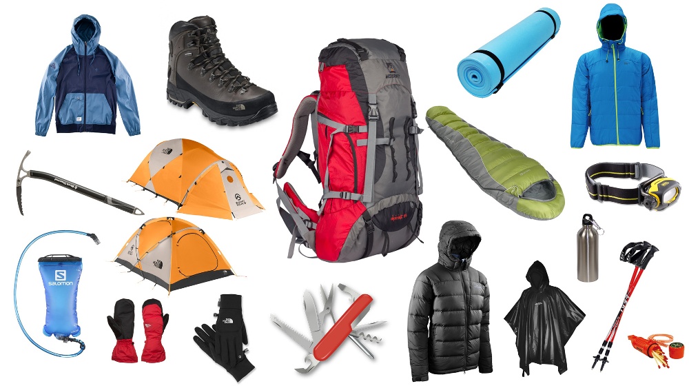
Trekking poles are strongly recommended for the numerous river crossings and boggy sections of the lower valley, while insulated gloves and a warm hat are essential for the cold, often windy summit day. A four-season sleeping bag rated for sub-zero conditions is necessary for nights at Bujuku Camp and beyond, and while no technical climbing hardware is required for the standard route, trekkers should expect to use their hands for balance on several scrambling sections, making a good pair of grippy, well-broken-in boots more important than any single piece of technical gear. Our full packing guide covers this topic in complete detail, layer by layer.
Safety Of Mount Speke (Is it safe?)
Altitude illness is the single most significant safety consideration on Mount Speke, given the elevations reached relative to the pace of ascent; a conservative, well-acclimatized itinerary is the most effective safeguard, alongside close monitoring by experienced guides trained to recognize early symptoms. Weather is the second major factor: sudden drops in temperature, heavy rain, and reduced visibility can develop quickly even on days that begin clear, and route-finding in poor visibility near the summit ridge is not something inexperienced trekkers should attempt without a qualified guide.
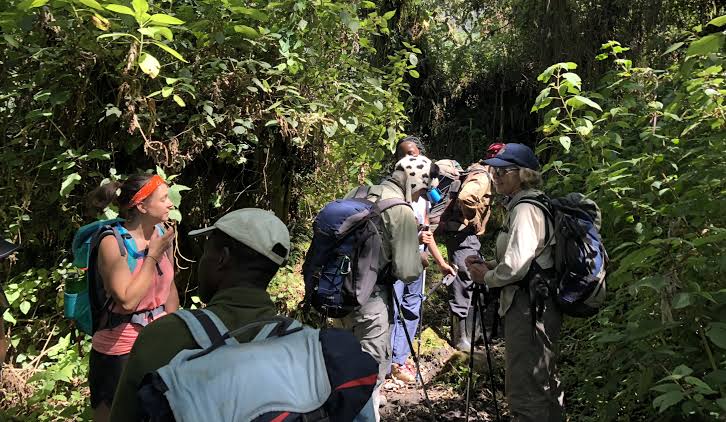
Slippery rock, especially on the scrambling sections near Stuhlmann’s Pass and the summit, and many river crossings along the route add to the physical risks, while the remoteness of the terrain makes reliable emergency evacuation procedures, coordinated between guides, park rangers, and, when necessary, external rescue support, an essential part of any well-run expedition. For all of these reasons, we strongly discourage independent attempts on Mount Speke; every ascent we organize is led by guides licensed by the Uganda Wildlife Authority with direct, current experience on this specific route.
Photography Guide
Mount Speke rewards photographers at almost every stage of the trek. Lake Bujuku, ringed by giant lobelias and framed simultaneously by Mount Stanley, Mount Baker, and Speke itself, is among the most photographed scenes in the entire range, particularly striking in the still air and clear light of early morning before cloud typically builds. The ascent to Stuhlmann’s Pass offers sweeping panoramas back across the Bujuku Valley and, on clear days, distant views into the Virunga landscape of the Democratic Republic of the Congo.
The summit ridge itself, though demanding underfoot, offers some of the most dramatic high-alpine photography available anywhere in East Africa: jagged rock silhouettes, distant glaciated ridgelines on Mount Stanley, and, in the right conditions, a sea of cloud filling the valleys below. Wildlife photography opportunities are best pursued in the lower montane forest, where patient, quiet observation can yield sightings of monkeys and forest birds that become progressively scarcer at higher elevations.
Conservation of Mount Speke
Mount Speke’s slopes lie entirely within Rwenzori Mountains National Park, managed by the Uganda Wildlife Authority under the broader framework of the park’s UNESCO World Heritage status, inscribed in 1994 in recognition of the range’s outstanding natural beauty and exceptional biodiversity. Conservation efforts here focus on habitat protection across the mountain’s distinct vegetation zones, control of poaching and unauthorized land use at the park boundary, and increasingly close partnership with surrounding Bakonzo communities, many of whom now work directly as licensed guides and porters on the Central Circuit trail.

Climate change remains the most significant long-term threat to the mountain’s character, with the near-total loss of Speke’s historical glacier cover over the past century serving as a visible, ongoing reminder of the broader pressures facing the range. Responsible trekking, minimizing waste, respecting park regulations, and supporting community-based guiding and porter services remain one of the most direct ways visitors can contribute to the mountain’s continued protection.
Comparison with Other Major Rwenzori Peaks
Understanding where Mount Speke fits within the broader Rwenzori massif helps trekkers choose the right objective for their goals and experience level.
Mountain | Height | Distinguishing Feature |
Mount Stanley | 5,109 m | Highest peak in the range; home to Margherita Peak and the range’s largest surviving glaciers |
Mount Speke | ~4,890 m | Fourth-highest peak in Africa; dramatic alpine ridges, quieter than Margherita Peak |
Mount Baker | 4,844 m | Noted for scenic approaches and classic ridge views; sixth-highest peak in Africa |
In practice, Mount Speke has much of the scale and drama of Mount Stanley’s Margherita Peak, including real high-alpine terrain and sweeping Rwenzori views, but without the roped glacier travel and extra permits and logistics needed for the range’s highest summit, making it an excellent standalone objective or a natural addition to a Mount Baker or Mount Stanley itinerary.