The Kilembe Trail Route is one of the most scenic and rewarding ways to explore the legendary Rwenzori Mountains in Uganda. Starting from Kilembe near Kasese and leading deep into the UNESCO-listed Rwenzori Mountains National Park, this route offers adventurous hikers the opportunity to trek through lush montane forests, giant heather zones, alpine valleys, glacial landscapes, and snow-capped peaks, including Margherita Peak on Mount Stanley, Africa’s third-highest summit. Known for its quieter trails, breathtaking scenery, and excellent mountain huts, the Kilembe Route is a preferred alternative to the Central Circuit trail for trekkers seeking a more remote and immersive Rwenzori experience. Beginning at Kilembe near Kasese, this route takes trekkers through dense tropical forests, giant lobelia-filled valleys, alpine moorlands, glaciers, and snow-covered summits that have earned the Rwenzoris the nickname “Mountains of the Moon.” Ideal for both experienced hikers and ambitious adventurers, the Kilembe Route is widely regarded as one of the most scenic mountain trekking experiences in East Africa, offering unmatched natural beauty, rich biodiversity, and a true wilderness experience.
Whether you are planning a multi-day mountain expedition or aiming to conquer Margherita Peak, the Kilembe Trail provides an unforgettable journey through one of Africa’s most unique and biodiverse mountain ecosystems.
The Kilembe trail/route of the Rwenzori Mountains, also known as the southern circuit, was formally established in 2009 after a new system of mountain huts was built; it was first traced in modern exploration by Professor Scott Elliott in 1895 and is now available as a 7-to-8-day expedition that approaches Margherita Peak (5,109 m)—Uganda’s highest summit and Africa’s third highest point—from the south and west, through a landscape of waterfalls, glacial passes, alpine meadows, and high-mountain views that the conventional northern route simply does not offer. For solo travelers who want the mountain largely to themselves; for couples seeking a journey of rare visual drama; for groups who want the conversation of the trail to be shaped by genuine wonder rather than relentless exertion; and for families with fit teenagers ready for the adventure of a lifetime, the Kilembe Trail is not the alternative to the Rwenzori. It is a different and, many would argue, superior version of it.
The Kilembe Trail shows you the Rwenzori from a side that most mountaineers never see — and that side, with waterfalls and glacial valleys and all, may be the finest thing on the mountain. |
Kilembe Trail: At a Glance
Route Type | Linear ascent and descent via southern circuit — begins and ends near Kilembe / Kyanjuki |
Total Distance | Approximately 52–60 kilometres depending on chosen itinerary variation |
Altitude Range | 1,450 m (Trailhead) to 5,109m (Margherita Peak, Mount Stanley) |
Duration Options | 3 days (Kalalama intro) / 4 days (Waterfalls trail) / 8 days (Margherita Peak summit) |
Difficulty | Moderate to Strenuous — 8-day Margherita summit requires glacier travel on Day 6 |
Managed By | Rwenzori Trekking Services (RTS)—southern circuit specialists |
Entry Point | Trekkers Hostel Kyanjuki, 12 km from Kasese past the Kilembe copper mines |
Vegetation Zones | 5 zones: Montane Forest / Bamboo-Mimulopsis / Giant Heather / Afro-Alpine / Nival-Glacial |
Camp Huts | Sine · Kalalama · Mutinda · Bugata · Butawu · Margherita Camp · Kiharo |
Signature Feature | Six major waterfalls in the lower valley — the finest cascade concentration in the Rwenzori |
Historical Note | First explored by Prof. Scott Elliott in 1895; modern trail officially opened in 2009 |
Best Months | January–February and June–August (summit clarity and most stable glacier conditions) |
A Trail with a History: The Story of the Kilembe Route
The valley from which the Kilembe Trail begins carries a particular kind of history — industrial, geological, and human — that the Central Circuit does not. The copper mines of Kilembe, operating from the 1950s until their closure in the 1970s and partial revival in recent years, cut deep into the southern foothills of the Rwenzori and brought thousands of workers, engineers, and their families to this corner of western Uganda. The Kilembe valley, in consequence, has a character that is different from the farmlands of Nyakalengija: it is a landscape shaped by both mountain geology and human endeavor, and the contrast between the industrial history visible in the valley below and the absolute, untouched wildness of the mountain above is one of the Kilembe Trail’s most quietly powerful qualities.
The trail itself has even older roots. Professor Scott Elliott, a British botanist and explorer, traced a version of this southern approach in 1895—eleven years before the Duke of Abruzzi made the first recorded ascent of Margherita Peak via the northern route in 1906. Elliott did not reach the summit, but his route through the southern valleys documented the botanical riches of the Rwenzori’s southern flanks for the first time. Those riches—the lobelias, the groundsels, the extraordinary heather forests—are precisely what Kilembe Trail trekkers walk through today, in a landscape that has been protected as a UNESCO World Heritage Site since 1994.
The modern trail, with its hut system and managed approach, was formally established in 2009 under Rwenzori Trekking Services — the operator holding the southern circuit concession — in response to growing trekker demand for an alternative to the increasingly popular Central Circuit. The construction of seven mountain huts from Sine Camp up to Margherita Camp gave the southern route the logistical infrastructure to support multi-day expeditions, and the trail has been steadily building a reputation among experienced Rwenzori trekkers as the more visually dramatic, botanically rich, and experientially distinct of the two main routes. The copper-mine history at the trailhead, the waterfalls in the lower valley, and the long western approach to Mount Stanley’s glaciers give the Kilembe Trail a narrative arc that the Central Circuit—magnificent as it is—cannot quite replicate.
How to Get to the Kilembe Trail
The Kilembe Trail begins at the Trekkers Hostel in Kyanjuki, a small settlement in the Kilembe valley approximately 12 kilometers from Kasese town on the road that passes the Kilembe copper mines. Kasese is the gateway town for all Rwenzori trekking and is the base from which your expedition departs.
From Entebbe International Airport or Kampala
Entebbe International Airport is approximately 420 kilometers from Kasese—a five-to-six-hour drive by your dedicated private vehicle along Uganda’s western highway, descending through Fort Portal and approaching Kasese from the northeast. The drive itself is genuinely scenic: the Rwenzori foothills appear to the southwest as you approach Kasese, and the copper-mine infrastructure of the Kilembe valley becomes visible in the hills above the town. Your vehicle and driver are seamlessly arranged as part of your expedition package, with timing calibrated to your flight arrival so that every connection is smooth and unhurried.
The Kilembe Valley Approach
From Kasese, the road to the Kilembe trailhead passes through the town of Kilembe itself, past the distinctive industrial architecture of the old copper-processing plant, and gradually climbs into the southern foothills of the Rwenzori. This 12-kilometer approach road offers the first proper views of the range’s southern face: a broad, cloud-draped ridgeline that already carries the sense of something significant on the other side of it. The Trekkers Hostel at Kyanjuki is the staging point: permits are processed, porter teams are assembled, equipment is checked, and your private guide briefs the entire team before the trail begins. Rwenzori Trekking Expeditions handles all of these arrangements seamlessly in advance.
By Charter Flight
For travelers combining the Kilembe Trail with a broader Uganda expedition—gorilla trekking in Bwindi Impenetrable Forest, wildlife safaris in Queen Elizabeth National Park, or chimpanzee tracking in Kibale Forest—charter flights from Entebbe or Kajjansi to Kasese Airfield reduce travel time to under an hour. The Kasese-to-Kilembe road transfer is then a short, scenic twenty minutes. We coordinate all aviation logistics on request and design combination itineraries that maximize the time available for the mountain without compressing the approach into an exhausting rush. Explore our Kilembe Trail combination packages here.
Uganda Visa and Entry Documentation
All international visitors require a valid Uganda entry visa applied for online through the Uganda Immigration Services portal at least three to four weeks before arrival. An East African tourist visa covering Uganda, Kenya, and Rwanda is available for multi-country travelers. All Uganda Wildlife Authority national park permits, climbing fees, and Rwenzori Trekking Services access arrangements are included in every Rwenzori Trekking Expeditions package and pre-arranged well in advance of your departure date. You arrive at Kyanjuki with nothing to sort out beyond shouldering your daypack.
Kilembe Trail vs. Central Circuit: Which Route Is Right for You?
Both trails reach Margherita Peak. Both pass through the Rwenzori’s five vegetation zones. Both are managed by community-based operators with decades of mountain experience, and both deliver the summit that defines the Rwenzori experience. The differences between them are real, meaningful, and worth understanding before you choose.
Choose the Kilembe Trail if…
You are drawn to dramatic waterfall scenery in the lower mountain: the Kilembe Trail crosses six significant waterfalls in its first days, which the Central Circuit Trail entirely misses. You want a more solitary mountain experience—the Kilembe trail/route carries significantly fewer trekkers than the Central Circuit trail, and you are unlikely to share a hut with strangers at any point. You are approaching the Rwenzori from the south or prefer the logistics of the Kilembe Valley starting point. You have eight days available and want the fullest possible southern circuit experience. You are returning to the Rwenzori after completing the Central Circuit and want to see the mountain from an entirely different perspective.
Choose the Central Circuit if…
You are prioritizing summit success with a shorter time commitment—the standard 7-day Central Circuit has a slightly shorter route to Margherita. You want to see Bujuku Lake and the classic upper valley amphitheater, which is visible from Bujuku Camp. You are combining the Rwenzori with other activities and need the most time-efficient route to the summit. You are on your first Rwenzori expedition and want to walk the trail that has shaped the mountain’s reputation for over a century. Our Central Circuit Trail guide is available for full comparison details.
The Five Vegetation Zones: An Immersive Step-by-Step Trekking Story
The Kilembe Trail’s particular genius lies in the way it reveals the Rwenzori’s ecological layering. Each vegetation zone arrives not as a textbook transition but as a physical experience—a change in temperature, in sound, in the smell of the air, and in the quality of light through the canopy. The following is not a description of what you will encounter on this trail. It is a narration of what it feels like to walk this trail.
ZONE 1 1,450m – 2,200m | The trail begins in the Kilembe valley at the Trekkers Hostel in Kyanjuki, surrounded by the sounds of the mining settlement and the rustle of the first montane forest above it. Within twenty minutes of leaving the hostel, the forest absorbs the path, and the valley falls away below. This area is the zone of waterfalls — the single most defining characteristic of the Kilembe Trail’s lower section. The first waterfall appears within the opening kilometers: a long white thread of water dropping from a forested cliff with the confidence of something that has been doing its job for centuries. By the end of Day 2, six major waterfalls will have marked the route, each one different in character—some broad and roaring, some narrow and vertical, some hidden around a bend in the trail so that the sound arrives before the sight. L’Hoest monkeys pass overhead in the canopy. Three-horned chameleons cling to trailside branches with the perfect stillness of creatures convinced of their invisibility. The Rwenzori turaco calls from somewhere deep in the forest, and its crimson underwing flashes when it finally moves. Sine Camp, at 2,585 meters, is reached on Day 1: a hut positioned in the forest with the sound of a nearby stream and the first real altitude of the circuit. Your cook team prepares the evening meal, which arrives warm and welcome. Above the camp, the peaks are entirely invisible. They are waiting. |
ZONE 2 2,200m – 3,200m | The bamboo-Mimulopsis zone announces itself with a change in the forest character that is immediately apparent: the broad-leaved montane trees give way to bamboo stems and to Mimulopsis elliotii, a plant named for Professor Scott Elliott himself, the first European to have traced this route. Mimulopsis flowers on an irregular cycle of approximately seven years, and when it blooms, its purple-blue flowers cover the forest in a spectacle that trekkers who have been fortunate enough to witness it describe as genuinely surreal. Even in non-flowering years, the bamboo-mimulopsis zone has a light and texture that is entirely its own: filtered, slightly golden, with the path narrowing as the vegetation crowds closer and the altitude beginning to make itself felt in the pace of breathing. Kalalama Camp, at 3,147 meters, is the Day 2 overnight. The hut sits in a clearing at the upper edge of the bamboo zone, and on clear evenings — rare but not impossible — the first glimpse of the southern ridgeline of the Rwenzori appears above the bamboo canopy. For most trekkers, this moment is the first time the scale of what lies above truly registers. The cook team has a warm dinner ready; the cold of the upper bamboo zone, dropping after sundown, makes the meal’s warmth doubly welcome. |
ZONE 3 3,200m – 3,800m | The Giant Heather zone on the Kilembe Trail has a character that is in some ways more dramatic than its equivalent on the Central Circuit, because the southern approach gives it a different relationship to the sky. On the Kilembe side of the range, the heather forests occupy steeper terrain, and the twisted trunks draped with old man’s beard lichen are frequently silhouetted against a backdrop of peaks rather than forest. Mutinda Camp at 3,688 meters, perched at the edge of a ridge that overlooks the entire Kilembe valley and, on clear days, the plains of western Uganda spreading south and east, is one of the finest viewpoint camps on either Rwenzori trail. From the hut door on a clear morning, the cultivated lowlands of the Kasese District are visible far below, the copper-mine infrastructure a tiny pattern in the valley, and the full southern arc of the Rwenzori rising above and behind. It is a view that orientates the trekker perfectly: below, the world they came from; above, the world they are climbing toward. The approach to Mutinda from Kalalama traverses steep bamboo and early heather terrain with genuine climbing character, the trail gaining altitude quickly and the views opening progressively as each ridge is crested. |
ZONE 4 3,800m – 4,500m | The Afro-Alpine Moorland on the Kilembe Trail is where the route’s distinction from the Central Circuit becomes most pronounced. Where the Central Circuit’s afro-alpine zone is dominated by the Bigo Bogs and the approach to Bujuku Lake, the Kilembe Trail’s upper alpine section is defined by glacial passes, high-altitude valleys, and the progressive revelation of Mount Baker and Mount Stanley from entirely different angles than the northern approach provides. Bugata Camp, at 4,062 meters, is the overnight on Day 3 of the full circuit, surrounded by giant lobelias in their most spectacular concentration on the southern route, the plants rising silver and skeletal from the saturated ground, the sky close enough at this altitude to seem personal. The ascent to Bamwanjara Pass at 4,450 meters on Day 4 is the first genuinely challenging moment of the route: steep, rocky terrain leading to a col with panoramic views of snow-capped peaks that stop most trekkers mid-stride. Hunwick’s Camp, perched at the edge of a drop that overlooks Mount Baker’s southern face, provides an overnight at the threshold between the alpine moorland and the high mountain. The glacier approaches are visible from here for the first time , close enough to seem real, far enough to remain aspirational. |
ZONE 5 4,500m – 5,109m | The Nival-Glacial zone of the Kilembe Trail is approached via the Scott Elliott Pass at approximately 4,372 metres — a high col between the massifs of Mount Baker and Mount Stanley that carries some of the finest 360-degree views available to a trekker on foot in the Rwenzori. From the pass, both the Kitandara Lakes (visible to the north on a clear day) and the glaciers of Mount Stanley (immediately to the west and above) are simultaneously in view. Margherita Camp, reached on Day 5 and positioned at 4,485 meters on the western approach to Mount Stanley, is the highest sleeping camp on the Kilembe Trail, colder, starker, and more dramatically positioned than Elena Camp on the Central Circuit. On Day 6, the start time is 3:00 a.m. rather than 2:00 a.m.; the timing is governed by the glaciers themselves: once the morning sun reaches the ice, melt begins, the trail becomes unstable, and the window for safe passage narrows. Your private guide leads the team upward through a darkness broken only by headlamps and the extraordinary density of an equatorial sky at 4,500 meters. The glaciers of Mount Stanley, crossed via fixed ropes, crampons, and ice axe, are the final physical barrier between the trekker and Margherita Peak at 5,109 meters. From the summit, the Congo Basin extends west to the infinite horizon. Uganda lies below in every other direction. And on the clearest days, the twin Kitandara Lakes, threads of turquoise in the valley far below are visible as a reminder of the full scale of what has been traversed. |
Where You Sleep: Accommodation Along the Kilembe Trail
Seven mountain huts, built in 2009 and maintained by Rwenzori Trekking Services, provide the overnight framework for the full Kilembe Trail circuit. They are solid, weatherproof, and characterful, each positioned with deliberate attention to the views it commands and the shelter it provides against the Rwenzori’s famously unpredictable weather. Sleeping platforms with foam mattresses, communal cook areas, and basic sanitation facilities are standard throughout. Your cook team prepares three hot meals daily from the first morning of the trail to the final descent.
Sine Camp Altitude: 2,585m Day 1 overnight | The first night on the Kilembe Trail, Sine Camp is a forest hut positioned in the lower montane zone above the Kyanjuki trailhead. The sound of a nearby stream fills the evening. The waterfalls of the lower valley are already behind you; the bamboo zone begins just above. Dinner here is the expedition’s first mountain meal, warm, substantial, and accompanied by the sounds of a Rwenzori forest at night. |
Kalalama Camp Altitude: 3,147m Day 2 overnight | Set at the upper edge of the bamboo-mimulopsis zone, Kalalama is the hut where the altitude first makes a genuine impression. Evening temperatures drop significantly after sunset. On clear evenings, the first glimpses of the upper ridgeline appear above the bamboo canopy to the north. This is the camp where many trekkers first properly understand the scale of the mountain above them. |
Mutinda Camp Altitude: 3,688m Day 3 overnight—KEY VIEWPOINT | The finest viewpoint camp on the entire Kilembe Trail. Perched at a ridge edge above the Kilembe Valley, Mutinda offers sweeping views south and east across western Uganda and north into the Rwenzori’s upper reaches. The heather zone surrounds the hut. The sunset from Mutinda — clouds permitting — is one of the most dramatic evening spectacles on any Rwenzori trail. Your private guide knows exactly where to stand. |
Bugata Camp Altitude: 4,062m Day 4 overnight | Deep in the Afro-alpine moorland, giant lobelias surround Bugata in their highest concentration on the southern circuit. The landscape has shed its forest character entirely; the sky feels close, and the silence has weight. This camp is the threshold before the high mountain — the last night before the passes and glaciers of the upper circuit begin. |
Butawu Camp Altitude: 3,974m Post-summit descent (Day 6) | Positioned in the upper heather-alpine transition zone on the descent from Margherita Camp, Butawu provides the post-summit overnight stay for trekkers returning from the glacier. The summit is behind you; the descent continues in the morning. This camp has a particular quality — the physical exhaustion of summit day combined with the complete satisfaction of what has been achieved makes even the simplest dinner feel like a celebration. |
Margherita Camp Altitude: 4,485m Day 5 — Summit Eve staging camp | The highest camp on the Kilembe Trail is the staging point for the Margherita Glacier ascent. Cold, stark, exposed, and magnificent in equal measure. Equipment is checked here: crampons fitted, harnesses adjusted, and ice axes confirmed. The 3:00 a.m. alarm is set early. Your cook team prepares a pre-dawn breakfast. The night sky above Margherita Camp, at this altitude and this latitude, is among the finest you will see anywhere on earth. |
Kiharo Camp Altitude: 3,460m Day 7 — Final descent overnight | Set in the heather-alpine zone on the final descent toward the trailhead, Kiharo marks the last night on the mountain. The character of this camp is one of completion: the summit is done, the high terrain is behind, and the forest sounds are beginning to return below. Dinner at Kiharo has the quality of a final chapter: warm food, good company, and the mountain releasing its hold. |
For accommodation before and after the trek, Kasese offers the Margherita Hotel — named for the peak you will have climbed — with comfortable rooms, reliable hot water, and a restaurant that returning trekkers genuinely appreciate. Ruboni Community Camp, at the base of the mountains in the Nyakalengija area, is an option for those arriving a day early and wanting to absorb the mountain atmosphere before departure. Both are coordinated by our team as part of your arrival and departure logistics. View our full Kasese accommodation guide here.
The Rwenzori Mountain Ranges Visible from the Kilembe Trail
The Kilembe Trail’s southern and western approach to the Rwenzori massifs offers peak views that are distinctly different from those available on the Central Circuit. In particular, the southern face of Mount Baker and the western glaciers of Mount Stanley — which are rarely seen from the northern approach — are defining visual features of the Kilembe experience.
Mount Stanley 5,109m (Margherita Peak) | The summit objective is the 8-day Kilembe Trail expedition. Approached from the west via Margherita Camp and the Scott Elliott Pass, Mount Stanley presents a different and in many ways more dramatic glacial profile on the Kilembe Trail than on the Central Circuit. The Stanley Plateau and the summit glaciers are visible from Margherita Camp on Day 5, and the western approach on summit morning crosses ice formations that the northern route does not. At dawn on Day 6, climbers reach Margherita Peak (5,109m), with the Congo Basin to the west and all of Uganda below. |
Mount Baker 4,843m (Edward Peak) | The southern face of Mount Baker is one of the Kilembe Trail’s defining visual features. Baker’s southern buttresses, visible from Hunwick’s Camp and dramatically revealed on the approach to Bamwanjara Pass, present a more imposing and less-photographed profile than the eastern face visible from the Central Circuit. From the Scott Elliott Pass on Day 5, Mount Baker and Mount Stanley are simultaneously in view , a mountain panorama that is, for many Kilembe trekkers, the single finest image of the entire expedition. |
Mount Speke 4,890m (Vittorio Emanuele) | Visible from the upper camps of the Kilembe Trail, particularly from Margherita Camp and the Scott Elliott Pass, Mount Speke’s Vittorio Emanuele Peak rises to the northeast. On the Kilembe approach, Speke is seen in profile rather than face-on, its eastern ridgeline creating a long, elegant silhouette against the sky above the Bujuku Valley. Mount Speke summit attempts can be integrated into longer Kilembe Trail variations of 9 or more days. |
Mount Luigi di Savoia 4,627m (Weismann / Sella Peaks) | The massif is most visible from the lower and middle sections of the Kilembe Trail, particularly from Mutinda Camp and the upper heather zone. Mount Luigi di Savoia’s Weismann Peak (4,620m) and Sella Peak (4,627m) define the southern horizon for much of the Kilembe approach and provide context for the mountain’s scale before the upper circuit reveals the greater peaks further north. |
The Signature Attractions of the Kilembe Trail
Six Waterfalls: The Trail’s Most Distinctive Feature
No other route in the Rwenzori, and few trekking trails anywhere in East Africa, offer six significant waterfalls in the opening sections of the trail. Each cascade on the Kilembe Trail has its own personality: some drop from cliff faces in single long threads, others spread across broad rock slabs in wide fans of white water, and others are heard long before they are seen, the sound building around a bend in the forest path until the full spectacle of falling water fills the frame. The waterfalls are a gift of the Kilembe Valley’s particular geology, the southern slopes receive enormous volumes of rainfall, and the deeply incised valleys channel that water over cliff edges with a regularity and a drama that make the lower trail a genuinely spectacular walking experience regardless of the altitude above.
Mutinda Lookout
The views south and east across the Kilembe valley and the western Uganda plains from Mutinda Camp at 3,688 meters represent the finest mid-altitude viewpoint on either Rwenzori trail. On clear mornings—most common in the dry season windows—the Kasese district spreads below in a patchwork of green cultivated land, the copper-mine infrastructure of Kilembe just visible in the valley below, and the full southern arc of the Rwenzori rising above and to the north. This is the viewpoint that most Kilembe Trail trekkers photograph most obsessively, and with good reason.
Bamwanjara Pass
At 4,450 meters, Bamwanjara Pass is the first high col on the Kilembe Trail and the moment the upper mountain reveals itself fully for the first time. Snow-capped peaks visible to the west and north from the pass, the heather moorland dropping away on both sides, and the particular quality of silence that belongs to a high mountain pass in the middle of an equatorial range—this scene is the moment most Kilembe trekkers describe as the expedition’s first genuinely transformative view.
Scott Elliott Pass and the Kitandara View
The Scott Elliott Pass at approximately 4,372 meters connects the Kilembe Trail to the upper circuit and provides the most panoramic view of the entire route. From the pass, the twin Kitandara Lakes are visible to the north on clear days, a glimpse of the Central Circuit’s most beautiful camp from an elevation that makes them look like chips of turquoise in the valley below. To the west, the glaciers of Mount Stanley fill the skyline above Margherita Camp. This pass is where the full geography of the Rwenzori’s high mountain zone becomes comprehensible as a single landscape.
The Kilembe Copper Mine Heritage
The approach road to the Kilembe trailhead passes through one of Uganda’s most significant industrial heritage sites. The Kilembe copper mines operated from the 1950s and, at their peak, employed thousands of workers in a fully self-contained mining community. The processing infrastructure visible in the valley, ore crushers, conveyors, and the distinctive architecture of the industrial housing blocks is now partly preserved and partly being revived under recent investment agreements. Understanding this history before ascending into one of Africa’s most pristine wilderness areas gives the Kilembe Trail a particular resonance: the ancient mountain above, the human story below.
Flora of the Southern Circuit
The Kilembe Trail’s botanical character is as rich as, and in some zones richer than,the Central Circuit. Giant lobelias in the Bugata Camp area reach concentrations and individual sizes that botanists studying the southern circuit consistently rate among the finest in the entire range. Mimulopsis elliotii, named for the trail’s original explorer, blooms in irregular seven-year cycles, filling the bamboo zone with purple-blue color that is visible from considerable distances. The heather trees above 3,000 meters are draped in old man’s beard lichen with a density that creates cathedral-like filtered light on overcast days. For botanical travelers, the Kilembe Trail is arguably the more rewarding of the two Rwenzori routes.
Best Time to Trek the Kilembe Trail
The Kilembe Trail shares the Rwenzori’s general weather patterns, equatorial, wet, and self-generating, but its southern exposure gives it slightly different microclimatic characteristics from the Central Circuit. In practical terms, the timing advice for the two routes is similar, but the Kilembe Trail’s waterfall sections are genuinely more dramatic in and around the wetter seasons.
January and February — Best for Summit Clarity
This is the primary dry season and the optimal period for attempts on Margherita Peak via the Kilembe Trail. Glacier conditions on the western approach are most stable, the Scott Elliott Pass is clearest, and summit-day visibility is at its maximum. The waterfalls in the lower valley are lower in volume but still beautiful. January and February availability fills quickly — book four to six months in advance for these dates.
June, July, and August, Most Popular Season
The long dry season represents the Kilembe Trail’s peak period. Conditions are reliable, the mountain huts are warmest in atmosphere, and the longer days make the bigger ascent days more comfortable. This is also the season when Mutinda Camp’s evening views are most consistently clear. The waterfalls are fuller than in the dry season — a balance of manageable weather and spectacular lower-trail scenery that makes June-August the most well-rounded window for the full Kilembe experience.
March–May and September–November — Atmospheric but Wetter
The transitional and wetter periods. The Kilembe Trail’s waterfall sections are at their most dramatic in the wetter months, the cascades are powerful, the forest is intensely lush, and the mist in the lower valley creates a quality of atmosphere that is genuinely special. Summit success rates on Margherita drop in these periods, and the approach to the Scott Elliott Pass becomes more demanding. For trekkers whose primary goal is the forest and mid-mountain experience rather than the glacier summit, these months carry a beauty that the dry season cannot replicate. April and November, the wettest months, are best avoided for summit-focused expeditions.
Waterfall Trekking — Year Round
The 4-day Kilembe Waterfalls Trek — covering the lower circuit as far as Kalalama Camp and returning via the waterfall route — is available and worthwhile in every month of the year. The waterfalls are most powerful in the wetter seasons and most accessible in the drier ones. For families, solo travelers, and couples seeking a 3-to-4-day Rwenzori experience without summit altitude, this shorter option on the Kilembe Trail provides extraordinary value in any season.
What to Wear and Carry: Gear for the Kilembe Trail
The Kilembe Trail’s southern approach, wetter in the lower sections due to the valley’s exposure and colder at the upper camps due to the altitude of Margherita Camp, demands thorough preparation. The gear requirements overlap significantly with the Central Circuit but carry some specific nuances worth noting.
Footwear
The lower Kilembe Trail — particularly around the waterfall sections and the forest zone between Kyanjuki and Kalalama — is consistently wet underfoot. Rubber boots (gumboots) are provided complimentary to every client of Rwenzori Trekking Expeditions and are essential for these sections. Waterproof hiking boots rated for rocky terrain are required from Mutinda Camp upward and for all upper-mountain and summit-day travel. Crampons for the glacier sections on Day 6 are provided as part of the summit package.
Sleeping Bag
A sleeping bag rated for a minimum temperature of -10°C is included. Margherita Camp, at 4,485 meters, is the coldest sleeping position on the Kilembe Trail, cold enough that experienced guides advise sleeping fully dressed in base layers with the sleeping bag sealed as tightly as possible. The 3:00 a.m. summit start makes pre-dawn warmth a practical matter rather than a comfort preference.
Waterproof Outer Layer
The Kilembe Trail’s lower sections are wetter than the equivalent stages of the Central Circuit. A quality waterproof shell jacket and waterproof trousers that can sustain prolonged rainfall without saturating are more important here than on the northern approach. Both should be breathable,the physical exertion of the steep lower trail sections generates enough heat that a non-breathable waterproof becomes uncomfortable within minutes.
Technical Summit Equipment — Fully Provided
All technical equipment for the glacier sections on Day 6, crampons, ice axes, harnesses, belay devices, fixed ropes, and helmets, is provided by Rwenzori Trekking Expeditions as part of every Margherita Peak expedition via the Kilembe Trail. On the evening of Day 5, Margherita Camp hosts the briefing and fitting.
Additional Essentials
Trekking poles are particularly valuable on the Kilembe Trail’s steep lower sections and on the long descents of Days 7 and 8. A quality headlamp is essential for the 3:00 a.m. summit departure on Day 6. High-factor sunscreen and UV-protective sunglasses are critical from Day 3 upward. Three liters of water capacity per day is the minimum from Bugata Camp onward. Camera gear benefits from additional waterproofing in the lower valley — the waterfall sections create significant spray. View our complete Kilembe Trail packing list here.
Physical Strength and Expedition Preparation
The Kilembe Trail’s difficulty profile differs slightly from the Central Circuit. The lower sections, with their steep valley approach through the waterfall zone and the long bamboo-mimulopsis ascent to Kalalama, are more consistently steep than the equivalent stages on the Central Circuit, where the trail is better-graded over a longer distance. The upper sections, from Bugata Camp through Bamwanjara Pass to the Scott Elliott Pass and Margherita Camp, involve sustained altitude gain at elevations where oxygen is genuinely limited.
Difficulty Rating
The 8-day Kilembe Trail to Margherita Peak is rated Challenging to Strenuous. The 4-day Waterfalls Trek and the 3-day Kalalama option are rated Moderate and are accessible to confident recreational hikers with adequate preparation. Summit day on the full circuit is the most demanding single day of the expedition: a 3:00 a.m. start, glacier travel on crampons, twelve or more hours of total effort, and oxygen at approximately 58% of sea-level concentration at the summit.
Recommended Training Programme
Six months before departure: establish a consistent aerobic base of at least four hours per week, running, cycling, or fast walking. Four months before: introduce regular uphill hiking with at least 600–800 meters of elevation gain per session. Two months before: complete at least two multi-day back-to-back hiking sessions. One month before: reduce intensity while maintaining frequency. Arrive rested. Altitude experience above 3,000 meters, while not mandatory, is strongly recommended for the summit expedition. Our full fitness preparation guide is available on the Rwenzori Trekking Expeditions website.
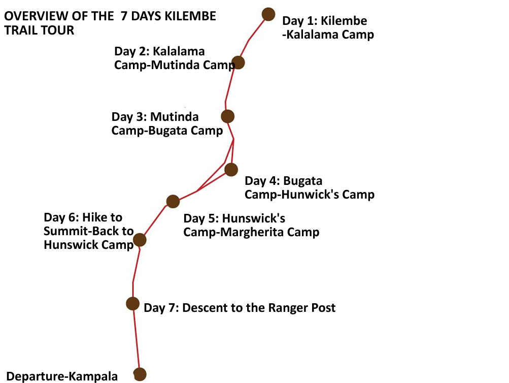
Kilembe Trail Itinerary Options
3-Day Kalalama Trek | Lower circuit to Kalalama Camp (3,147m) and return. It includes the first three waterfalls, the bamboo forest, and the first mountain huts. Ideal for beginners or those with limited time. Suitable for fit families. |
4-Day Waterfalls Hike | Complete all six major waterfalls of the lower Kilembe Trail. Reaches Kalalama and explores the upper waterfall sections before descent. The trail’s most accessible signature experience. |
4-Day Mutinda Lookout Trek | Ascends to Mutinda Camp (3,688m) for the finest viewpoint on the southern circuit. All vegetation zones to the heather zone, all six waterfalls, and the panoramic Kilembe valley view. |
8-Day Margherita Peak Expedition | The full Kilembe Trail circuit to Margherita Peak (5,109m) via Margherita Camp and the Scott Elliott Pass. The definitive southern circuit experience. |
8-Day Kilembe via Central Return | Ascends via the Kilembe Trail and descends via the Central Circuit, creating a true traverse of the Rwenzori range from south to north. The most comprehensive single Rwenzori experience available. |
Kilembe + Gorilla Trekking | Combines the Kilembe Trail with gorilla trekking in Bwindi Impenetrable Forest — western Uganda’s two greatest wilderness experiences. 12–14 days total, seamlessly arranged. |
All Kilembe Trail itineraries are available as privately guided expeditions, designed and operated exclusively around your group. Contact our team to discuss the right variation for your fitness level, timeline, and objectives.
How to Plan Your Kilembe Trail Expedition
Step 1: Choose Your Itinerary Length
Begin with an honest assessment of your available time and summit aspirations. The 4-day Waterfalls Trek is the entry point, accessible, spectacular, and complete in itself. The full 8-day Margherita circuit demands genuine fitness and altitude preparation but delivers the most complete Rwenzori experience available via the southern route. Our team provides pre-booking consultations to help you identify the right format.
Step 2: Book Early
The Kilembe Trail is significantly less crowded than the Central Circuit, which means availability is less of a constraint, but the dry-season windows (January–February and June–August) are popular and the hut capacity is limited. Book a minimum of two to three months ahead for most dates and four to five months ahead for January–February expeditions. A deposit activates all permit, hut, and logistics arrangements.
Step 3: Build Your Fitness Base
The Kilembe Trail’s steep lower sections reward a fitness base that includes regular uphill hiking. Flat aerobic fitness is necessary but not sufficient — train on elevation if at all possible. Our fitness preparation guide provides week-by-week frameworks for all starting fitness levels.
Step 4: Secure Travel Insurance
Comprehensive travel insurance covering high-altitude trekking to 5,200 meters and helicopter medical evacuation is required for all participants. Secure this insurance before confirming any other element of the expedition. Evidence of adequate coverage is requested at booking confirmation.
Step 5: Arrive at Kyanjuki well rested.
Build a night in Kasese into your Uganda itinerary if at all possible. The Margherita Hotel in Kasese provides comfortable pre-trek accommodation, a satisfying dinner, and a short transfer to the Kyanjuki trailhead the following morning. Starting the Kilembe Trail after a night of genuine rest, rather than on the same day as a five-hour road transfer, makes a measurable difference to the first day’s experience.
What Is Included in Your Kilembe Trail Expedition
Every Kilembe Trail expedition with Rwenzori Trekking Expeditions is comprehensively provisioned. Your private, licensed mountain guide accompanies the team for the full duration of the trek, an experienced Bakonzo guide with personal knowledge of the Kilembe Trail in every season, every weather condition, and at every level of trekker experience. A Uganda Wildlife Authority ranger guide is embedded in your team throughout. Your dedicated porter team carries all expedition supplies in specialist waterproof drums, ensuring that your personal daypack remains manageable even on the most demanding days.
Three hot meals daily are prepared by your cook team from Day 1 departure to final descent: substantial breakfasts, packed trail lunches, and warming evening dinners designed for caloric density and trail morale. Your cook team also provides hot drinks in the morning and evening throughout the expedition. Your trip includes all Uganda Wildlife Authority national park entry fees and Kilembe Trail climbing permits, which are pre-arranged. Complete technical summit equipment for glacier sections, crampons, ice axes, harnesses, fixed ropes, and helmets are provided for the 8-day Margherita expedition. Complimentary rubber boots are provided for all lower-trail sections. A Margherita Peak summit certificate is presented upon completion of the ascent. Emergency first aid equipment and supplemental oxygen are carried on all summit expeditions. Private transfer from Kasese to the Kyanjuki trailhead and return is included.
What Is Not Included
International flight and Uganda entry visa costs are the responsibility of each traveler. Accommodation in Kasese before and after the trek is not included in the mountain package; our team will provide recommendations and help with reservations. Personal trekking gear: sleeping bag, hiking boots, personal clothing system, and trekking poles are each trekker’s own responsibility, with rental options coordinated locally in Kasese. Comprehensive travel insurance covering high-altitude trekking to 5,200 meters and helicopter evacuation is required and not included. Personal snacks, alcoholic beverages, and personal purchases on the mountain are not included. Gratuities for guides and porters are entirely at each client’s discretion and warmly encouraged.
Begin Your Kilembe Trail Journey
“Most people who come to the Rwenzori take the northern route. The southern circuit — the Kilembe Trail — is the mountain at its most beautiful, its most dramatic, and its most personal. The trekkers who find it rarely talk about it as the alternative. They talk about it as the one they will return to. |
You have read this far, which means the Kilembe Trail is already doing what it does to most people who encounter it, creating a quiet insistence that is hard to explain and harder to ignore. This trek is not a trail that announces itself loudly. It does not have the Central Circuit’s century-long reputation or its place on every Rwenzori overview page. What it has, instead, is six waterfalls in a southern valley that most trekkers never see; a lookout camp that frames all of western Uganda below and all of the Rwenzori above; a historical thread running from Professor Scott Elliott’s 1895 exploration through the old copper mines in the valley to the equatorial glaciers at 5,109 meters; and the particular quality of a mountain experience that belongs, almost entirely, to the people walking it on any given day.
Rwenzori Trekking Expeditions designs every Kilembe Trail expedition as a private, personally guided journey shaped around the specific people undertaking it. The permits are arranged. The porter team is briefed. The waterfall sections are timed for the best light. The cook is at Margherita Camp before you are, with breakfast ready for the 3:00 a.m. departure. The summit certificate is waiting at the bottom of the glacier. The private vehicle that brings you back to Kasese is already confirmed for the afternoon of your final descent.
No decision is left to chance. No logistical gap is yours to manage. The only thing the Kilembe Trail asks of you is that you come ready to be genuinely surprised by what a mountain most people have never heard of can do to a person willing to walk its southern approach.
Frequently Asked Questions
The following answers address the questions that real Kilembe Trail trekkers ask most, before booking, during planning, and on the mountain itself. We answer them with the directness and honesty we bring to every pre-expedition conversation.
What is the Kilembe Trail in the Rwenzori Mountains?
The Kilembe Trail, also known as the Southern Circuit, is the second major trekking route through Rwenzori Mountains National Park in western Uganda. Established formally in 2009, it approaches the Rwenzori range from the south via the Kilembe copper-mine valley, beginning at the Trekkers Hostel in Kyanjuki (1,450 m) and ascending through seven mountain huts to Margherita Camp (4,485 m), from which summit day reaches Margherita Peak (5,109 m), Uganda’s highest point and Africa’s third highest summit. Rwenzori Trekking Services manages the trail, which is available in 3-day, 4-day, and 8-day itinerary formats.
How is the Kilembe Trail different from the Central Circuit?
The Kilembe Trail approaches the Rwenzori from the south rather than the east, giving it a fundamentally different character from the Central Circuit Trail. Its most distinctive features are six major waterfalls in the lower valley, entirely absent from the Central Circuit trail, a southern approach to Mount Baker and Mount Stanley that reveals their faces from rarely photographed angles, and a significantly lower trekker density that provides a more solitary mountain experience. The Kilembe Trail is slightly longer in its summit-day preparations (3:00 a.m. start vs. 2:00 a.m. on the Central Circuit) and requires one additional day for the full summit expedition. Many trekkers who have done both routes describe the Kilembe Trail as the more visually dramatic of the two.
How difficult is the Kilembe Trail? Can beginners do it?
The 3-day Kalalama Trek and 4-day Waterfalls Hike are accessible to fit recreational hikers and are rated Moderate. The full 8-day Margherita Peak expedition is rated as challenging to strenuous and requires solid multi-day hiking fitness and a willingness to manage genuine altitude. Summit day involves glacier travel on crampons with fixed ropes and ice axes; all equipment is provided and training is given at camp the night before. No prior technical climbing experience is required, but prior altitude experience above 3,000 meters is strongly recommended for the summit expedition.
What are the waterfalls on the Kilembe Trail?
The Kilembe Trail crosses six significant waterfalls in its lower sections between the Kyanjuki trailhead and Kalalama Camp. Each waterfall has a distinct character; some are narrow vertical drops from cliff faces, others are broad cascades across open rock. They are most dramatic during and after the wetter seasons (March–May and September–November) when rainfall volume is highest and most accessible in the dry season when trail conditions underfoot are firmer. The 4-day Rwenzori Waterfalls Hike is specifically designed to visit all six cascades and is the Kilembe Trail’s most accessible signature experience.
What time does summit day start on the Kilembe Trail?
Summit day on the Kilembe Trail: Day 6 of the full 8-day Rwenzori trek to Margherita Peak kIlembe begins at 3:00 a.m. The timing is governed by the glacier: as morning sun reaches the ice, melt begins, and the trail conditions on the upper approach deteriorate. By starting in darkness and reaching the summit at or around dawn, the team crosses the glacier while conditions are firmest and returns to Margherita Camp well before the afternoon melt cycle. Your cook team rises before 2:00 a.m. to prepare breakfast. Equipment is pre-checked at camp on the previous evening. The night sky above Margherita Camp during the pre-dawn start is, by all accounts, extraordinary.
Where does the Kilembe Trail start, and how do I get there?
The Kilembe Trail begins at the Trekkers Hostel in Kyanjuki, approximately 12 kilometers from Kasese town via the Kilembe copper-mine road. Kasese is accessible by a five-to-six-hour private road transfer from Entebbe International Airport or Kampala or by charter flight to Kasese Airfield (approximately 45 minutes from Entebbe). All transfers are arranged by Rwenzori Trekking Expeditions as part of every expedition package. You arrive at Kyanjuki with everything confirmed and nothing to organize independently.
What is Mutinda Camp, and why is it significant?
Mutinda Camp, at 3,688 meters, is the finest viewpoint camp on the entire Kilembe Trail—and, many guides argue, on either Rwenzori route. Positioned on a ridge edge above the Kilembe valley, it offers sweeping views south across western Uganda’s cultivated lowlands and north into the upper reaches of the Rwenzori range. On a clear morning at Mutinda, you can see the Kasese district spreading below, the copper-mine infrastructure of the Kilembe valley, and the full southern arc of the Rwenzori above. The Mutinda Lookout is also accessible as a 4-day standalone trek for those who want the finest Kilembe Trail view without the full summit expedition.
Is travel insurance required for the Kilembe Trail?
Yes. Comprehensive travel insurance covering high-altitude trekking to a minimum of 5,200 meters and helicopter medical evacuation is required for all participants on Rwenzori Trekking Expeditions journeys. Evacuation from the Kilembe Trail, particularly from the upper mountain, is complex and expensive without coverage. We recommend specialist adventure policies from World Nomads, Battleface, or Allianz. You must provide evidence of adequate insurance at booking confirmation, and it must be in place before the expedition departs.
Can families with children do the Kilembe Trail?
Yes, with the right itinerary. The 3-day Kalalama Trek and 4-day Waterfalls Hike are accessible to fit, motivated children aged 12 and above accompanied by a responsible adult and represent an extraordinary introduction to the Rwenzori Mountains. The full 8-day Margherita summit expedition is recommended for participants aged 16 and above with solid hiking fitness. For families with younger children, the lower Kilembe Trail waterfalls are among the finest family hiking experiences in Uganda. We design all family itineraries individually—contact our team to discuss what is appropriate for your specific group.
What happens to the Rwenzori glaciers on the Kilembe Trail approach?
The glaciers approached on the Kilembe Trail—specifically the western ice fields of Mount Stanley, reached via Margherita Camp—have retreated by over 80% since the late nineteenth century. Scientific projections suggest complete disappearance by approximately 2050. The glacier sections crossed on summit day via the Kilembe Trail represent some of the last accessible equatorial ice in Africa. Walking on them today is walking on something that will not exist for the next generation of mountaineers—a context that gives every Kilembe Trail summit expedition a quiet urgency that no amount of marketing can manufacture