Where Is Mount Gessi?
Mount Gessi sits in the northern portion of the Rwenzori range, immediately north of the triangle formed by Mounts Stanley, Speke, and Baker. It lies directly alongside Mount Emin, separated from it by a narrow valley running roughly north–south. The two massifs are close enough that they are frequently discussed together in trekking and geographic literature.
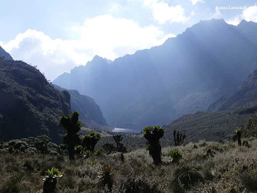
The massif’s ridgeline runs broadly north-south, with its higher summits toward the southern end. Trekkers most commonly encounter views of Mount Gessi from vantage points along the Central Circuit Trail and the Kilembe Trail, as well as from the Congolese side of the range via routes approaching from Mutsora. No standard commercial itinerary currently summits Mount Gessi directly; it is experienced overwhelmingly as a scenic feature of the wider trekking landscape rather than as a destination climb.
Precise, publicly available GPS coordinates and a detailed relief map specific to Mount Gessi’s summits are less readily available than for the Rwenzori’s more thoroughly surveyed peaks; travelers requiring exact coordinates for route planning should confirm current data directly with the Uganda Wildlife Authority or an experienced local guide before finalizing an itinerary.
Why Is Mount Gessi Important?
Mount Gessi’s importance lies less in individual fame than in its contribution to the coherence of the Rwenzori landscape as a whole.
- Landscape contribution: it forms one continuous link in the chain of massifs that gives the range its dramatic, saw-toothed skyline, and its valleys feed river systems shared with the rest of the park.
- Geological significance: as a fault-block formation built from ancient metamorphic basement rock, Gessi preserves the same geological record of Albertine Rift uplift found across the range, offering researchers additional exposure points for studying that history.
- Ecological importance: its slopes carry the same vegetation sequence — montane forest through to Afro-alpine moorland — that supports the Rwenzori’s broader endemic biodiversity, meaning its habitat value does not depend on how frequently its summit is visited.
- Scenic value: ridgelines, glacially carved valleys, and remote alpine views around Gessi rival those of the more famous massifs, simply with far fewer visitors to witness them.
- Role in the World Heritage Site: Mount Gessi is part of Rwenzori Mountains National Park and is fully included in the area recognized by UNESCO’s 1994 World Heritage inscription, adding its share of the qualities, exceptional scenery, and outstanding biodiversity habitat that justified that listing.
Put simply, Mount Gessi deserves attention not because it competes with Mount Stanley for height but because understanding the Rwenzori as a connected, functioning ecosystem requires understanding every one of its six massifs, not only the tallest.
The Peaks of Mount Gessi
Mount Gessi’s summit area is formed by twin peaks.
Iolanda Peak
- Elevation: approximately 4,715 m (15,470 ft) per the most widely cited figure (some sources place it lower, around 4,578 m; see the accuracy note above).
- Terrain: a rocky, north–south-trending ridge with the higher summit toward the southern end of the massif.
- Geology: built from the ancient metamorphic basement rock characteristic of the Rwenzori’s fault-block structure.
- Notes: As the higher of Gessi’s two summits, Iolanda is the reference point most commonly cited when the massif’s overall height is quoted.
Bottego Peak
- Elevation: approximately 4,699 m (15,418 ft).
- Terrain: Gessi’s secondary summit, separated from Iolanda by a short ridge connection typical of the range’s twin-peaked massifs.
- Climbing considerations: Published details specific to Bottego Peak’s individual climbing history are limited; where documentation search did not return reliable independent verification, this guide states that plainly rather than filling the gap with speculation.
History of Mount Gessi
Indigenous Knowledge and Cultural Significance
The Rwenzori range as a whole holds deep cultural and spiritual significance for the Bakonzo people, who have lived on its lower slopes for generations and possess detailed traditional knowledge of its valleys, weather patterns, and resources, knowledge that continues to inform local guiding today, even where specific oral traditions relating to Mount Gessi by name are not widely documented in published literature.
The Origin of the Name
Mount Gessi is named after Romolo Gessi (1831–1881), also known as Gessi Pasha, an Italian soldier and explorer of north-east Africa. Gessi served under General Charles Gordon in Sudan during the 1870s and became the first person to circumnavigate and map Lake Albert, one of the key stages in the historical effort to trace the Nile’s sources, a search that eventually led European expeditions toward the Rwenzori itself. Gessi was later appointed governor of the Bahr-el-Ghazal province and worked to suppress the regional slave trade before his death in 1881.
European Exploration and the Duke of the Abruzzi Expedition
European interest in the Rwenzori as the long-rumoured snow-capped source region of the Nile grew through the late 19th century, culminating in the landmark 1906 expedition led by Luigi Amedeo di Savoia, Duke of the Abruzzi. That expedition undertook the first systematic mapping and first ascents of most of the range’s principal summits, including Margherita Peak on Mount Stanley, and named several peaks, including, in keeping with the era’s convention, Mount Gessi, after Italian explorers, patrons, and royal figures. Independently verifiable, detailed first-ascent records specific to Gessi’s own summits are less thoroughly documented in accessible literature than those for Mount Stanley, and this guide does not speculate on an exact first-ascent date for Iolanda or Bottego Peak without clearer primary sourcing.
Historical Mapping
Subsequent 20th-century surveys refined the altitude figures and nomenclature used across the range, though as noted above, some inconsistency in Mount Gessi’s published elevation persists in secondary sources to this day, likely reflecting differences between early expedition-era measurements and later, more precise surveys.
Geology Of Mount Gessi
Mount Gessi shares the same fundamental geological story as the rest of the Rwenzori range: formation through tectonic uplift rather than volcanic activity, setting it apart from most of East Africa’s other major peaks.
Formation Through Tectonic Uplift
The Rwenzori range, Mount Gessi included, was thrust upward as a fault block within the Albertine Rift, the western branch of the East African Rift System, over millions of years, rather than being built up by volcanic eruption. This makes the range one of the oldest and most geologically distinct mountain systems on the continent.
Ancient Metamorphic Basement Rock
The massif’s exposed rock is drawn substantially from ancient metamorphic basement material, gneisses and schists among them, with origins reaching back roughly two billion years, among the oldest exposed rock surfaces in East Africa.
Relationship to the Albertine Rift
As part of the Albertine Rift’s uplifted margin, Mount Gessi’s structure reflects the same regional tectonic forces responsible for the Rift Valley’s lakes, escarpments, and volcanic fields elsewhere in the region, despite the Rwenzori’s own non-volcanic origin.
Glacial Shaping of Ridges and Valleys
Repeated glaciation over the last ice ages carved the massif’s present-day ridgelines and valley profiles, leaving the steep, angular terrain visible today.
What Trekkers See on the Trail
On the ground, this geological history translates into exposed grey-brown metamorphic rock faces, sharply cut valley walls, and the occasional glacially polished surface along approach trails, physical, walkable evidence of processes that unfolded over hundreds of millions of years.
Glacial History
Like several of the Rwenzori’s smaller massifs, Mount Gessi’s glaciers have retreated substantially, and available scientific sources indicate that active ice on the massif has now effectively disappeared or reduced to negligible remnants, a pattern consistent with the broader, well-documented retreat affecting the range’s glacier systems as a whole. This guide does not claim the presence of current permanent ice on Mount Gessi without clearer supporting evidence.
Evidence of Former Glaciation
- U-shaped valleys: the massif’s valleys display the classic U-shaped cross-section left by glacial erosion, distinct from the V-shaped profiles cut by rivers alone.
- Moraines: ridges and debris deposits around the lower slopes mark the former extent of ice that has since retreated or vanished entirely.
- Glacially scoured rock: polished, striated rock surfaces in places along approach routes offer visible evidence of ice movement from an earlier, more extensively glaciated period.
Taken together, this landscape offers trekkers a rare opportunity to read a mountain’s glacial history directly from its terrain, even where the ice itself is largely gone.
Vegetation Zones Around Mount Gessi
Approaches to Mount Gessi pass through the same broad altitudinal sequence found across the Rwenzori range, compressed into a comparatively short vertical distance.
Zone | Approx. Altitude | Character Around Gessi |
Montane Forest | 1,800 – 2,500 m | Dense tropical forest on lower approach trails |
Bamboo Zone | 2,500 – 3,000 m | Yushania alpina bamboo stands, cool and misty |
Heather Zone | 3,000 – 3,800 m | Moss-draped giant heather, boggy ground |
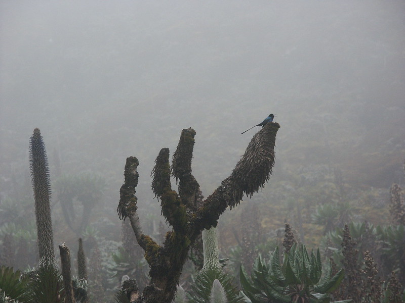
Afro-alpine Moorland | 3,800 – 4,500 m | Tussock moor, giant lobelias and groundsels in sheltered pockets |
High-Altitude Rocky Zone | Above ~4,500 m | Sparse mosses, lichens, and bare rock on the upper massif |
As with the rest of the range, altitude is the dominant force shaping this progression: rainfall and cloud cover stay consistently high throughout, while falling temperature with elevation determines which plant communities can survive at each stage.
Wildlife in the Rwenzori Mountains
Dedicated wildlife survey data specific to the Mount Gessi massif is more limited than for better-studied areas of the park, such as the Central Circuit corridor, a gap this guide notes honestly rather than filling with unverified detail. What is well established is the general pattern of wildlife distribution by habitat zone across the Rwenzori, which applies to Gessi’s slopes as it does elsewhere in the range.
- Primates in lower forests: Blue monkeys and black-and-white colobus are the most likely sightings on lower forested approach trails.
- Albertine Rift endemic birds: several of the region’s Albertine Rift endemic bird species can plausibly be encountered in the bamboo, heather, and moorland zones around the massif, consistent with their known range elsewhere in the park.
- Forest mammals: duikers and smaller forest mammals typical of the bamboo and heather zones are expected, based on habitat similarity to well-studied parts of the range.
- Amphibians: Cool, damp montane and bamboo forest conditions support amphibian species typical of the Rwenzori’s mid-altitude zones, though Gessi-specific survey records are limited.
- Invertebrates: A range of cold-adapted invertebrates, including those associated with giant lobelia stands, are expected in the Afro-alpine zone by analogy with better-documented parts of the moorland.
Sightings are, in general, most likely in the lower montane forest, where wildlife density is highest across the entire park; the more remote upper reaches of Gessi see markedly less wildlife, consistent with the pattern found on all the range’s higher massifs.
Trekking Around Mount Gessi
Mount Gessi is, for the overwhelming majority of visitors, a mountain to be viewed rather than summited.
Routes That Provide Views
Sections of both the Central Circuit Trail and the Kilembe Trail bring trekkers within clear sight of the massif, particularly from higher camps and ridgelines in the Bujuku and Bugata areas. Routes approaching from the Congolese side, via Mutsora, offer an alternative, considerably less-travelled vantage.
Are Summit Ascents Common?
No. Unlike Mount Stanley’s Margherita Peak, Mount Gessi’s summits are not part of any standard commercial itinerary offered by trekking operators in the region, including our own. Ascents, where they occur at all, are the domain of specialist, self-organized mountaineering expeditions rather than typical guided treks.
Nearby Camps
Camps along the Central Circuit and Kilembe routes in the Bujuku, Bugata, and Kiharo areas keep trekkers within scenic range of the massif and do not require any deviation from established, regularly serviced trekking infrastructure.
How Mount Gessi Fits Into Longer Expeditions
Most travelers see Mount Gessi as one dramatic feature among several during a longer Central Circuit or combined-peaks expedition, rather than as a trek in its own right; its value lies in the depth it adds to the wider Rwenzori experience, not in a dedicated itinerary built around it.
Difficulty and Accessibility
- Terrain: steep, rocky, and often wet underfoot, consistent with the Rwenzori’s broader reputation for challenging trail conditions.
- Elevation: approach routes reach into the Afro-alpine zone (3,800–4,500 m), where altitude effects become a genuine factor for trekkers, regardless of whether the summit itself is attempted.
- Trail conditions: mud and bog are common through the Heather Zone approaches, similar to conditions found elsewhere on the range’s Central Circuit.
- Route-finding: Routes to viewing points near Gessi are less well-trodden and less thoroughly signed than the core Central Circuit trail, making an experienced local guide essential rather than optional.
- Fitness requirements: a good level of trekking fitness is required for the approach trails; summit attempts on Gessi itself demand a mountaineering-level skill set well beyond standard trekking fitness.
SET YOUR EXPECTATIONS To be direct: on virtually all commercial Rwenzori itineraries, including ours, Mount Gessi is a mountain you view, not one you climb. If a genuine summit attempt on Iolanda or Bottego Peak interests you, the endeavor requires a bespoke, specialist mountaineering arrangement well outside standard trekking packages. |
Weather and Climate
Mount Gessi experiences the same broad climatic pattern found across the Rwenzori, shaped primarily by altitude and the range’s exceptionally high, consistent rainfall.
- Rainfall: heavy and frequent at all elevations, with little true dry season by the standards of lowland East Africa.
- Cloud cover: near-constant through the mid and upper elevations, often settling in by early afternoon even on comparatively clear days.
- Temperature by elevation: warm and humid in the lower forest, falling steadily with altitude to near-freezing or below-freezing conditions in the Afro-alpine zone and above.
- Seasonal patterns: the two relatively drier windows, December–February and June–August, bring somewhat reduced rainfall and improved visibility, though conditions remain genuinely changeable year-round.
- Visibility: clear, unobstructed views of Gessi’s ridgeline are never guaranteed on any given day, given the persistence of cloud at this altitude; early morning generally offers the best visibility before afternoon cloud builds.
Best Time to Visit/Climb/TRek/Hike Mount Gessi
The two drier trekking windows, roughly December to February and June to August, offer the best combination of firmer trail conditions and clearer views of Mount Gessi’s ridgeline from nearby vantage points. Outside these windows, the massif remains visible on clear mornings, but afternoon cloud and heavier rain make sustained views and comfortable trekking conditions on approach trails less reliable.
- Photography: Dawn and mid-morning in the dry windows offer the best odds of an unobstructed view of Gessi’s twin peaks; afternoon clouds are a near-daily occurrence regardless of season.
- Trekking conditions: drier conditions reduce (though do not eliminate) the notorious mud on the Heather Zone approaches.
- Wildlife viewing: Wildlife activity in the lower montane forest is consistently strong throughout the year, giving more flexible timing to travelers whose primary interest is biodiversity rather than mountain views.
As with every part of the Rwenzori, weather at this altitude cannot be guaranteed on any single day, however favorable the season.
Photography Guide
- Best viewpoints: ridgeline vantage points along the Central Circuit near Bujuku and Bugata offer some of the clearest compositions of Gessi’s twin summits against the sky.
- Ridge panoramas: the sharp, glacially cut ridgelines of Gessi and neighboring Mount Emin photograph dramatically in the low, raking light of early morning.
- Valley landscapes: the U-shaped valleys separating Gessi from Emin offer strong foreground-to-background compositions, especially with mist settling in the valley floor.
- Afro-alpine vegetation: giant lobelias and groundsels in sheltered Afro-alpine pockets near the approach routes provide a striking, otherworldly foreground against the distant peaks.
- Sunrise opportunities: as with the rest of the range, the clearest air and best light typically occur in the first one to two hours after dawn, before the day’s clouds begin building.
Conservation On Rwenzori Mountain
Mount Gessi falls entirely within Rwenzori Mountains National Park, inscribed as a UNESCO World Heritage Site in 1994 in recognition of the range’s exceptional natural beauty and outstanding biodiversity value, protections that extend fully to Gessi’s slopes and valleys regardless of how infrequently they are visited.
- Habitat protection: the massif’s habitat is part of the connected ecosystem that supports the park’s endemic species, from lower forest primates to high-altitude Afro-alpine flora.
- Climate change: the apparent loss or substantial reduction of Gessi’s own glaciers mirrors the well-documented, accelerating retreat affecting the Rwenzori’s larger ice fields on Stanley, Speke, and Baker.
- Responsible trekking: Because approach routes to Gessi’s viewing points are less established and less heavily trafficked than the core Central Circuit trail, staying strictly on the marked trail matters even more here, given the slower recovery of undisturbed alpine ground.
- UWA’s management role: the Uganda Wildlife Authority manages the entire park, including the Gessi massif, through ranger patrols, permitting, and conservation planning, in coordination with international World Heritage monitoring.
Comparison with Other Major Rwenzori Mountains
Understanding where Mount Gessi sits among the range’s six principal massifs helps place it in context.
Mountain | Approx. Height | Notable Feature |
Mount Stanley | 5,109 m | Highest massif; home to Margherita Peak |
Mount Speke | ~4,890 m | Second-highest peaks: Vittorio Emanuele, Ensonga, Johnston |
Mount Baker | ~4,844 m | Edward Peak and scenic alpine ridges |
Mount Emin | ~4,798 m | Quiet, seldom-climbed neighbour of Mount Gessi |
Mount Gessi | ~4,715 m (verify before publication) | Remote massif with twin peaks Iolanda & Bottego; significant geological and ecological value |
Mount Luigi di Savoia | ~4,627 m | Range’s lowest main massif; long multi-peaked ridge |
All figures above should be verified against current authoritative sources before publication, given the range-wide variation in historically cited elevations.