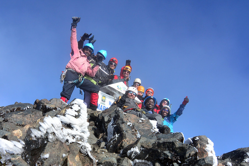
Rwenzori Mountains Uganda:Africa's Mountains of the Moon

Plan your Rwenzori Mountains trek: routes, cost, best time, packing list, safety & itineraries to Margherita Peak with expert guides.  Whether you’re planning a short nature hike, a multi-day trekking adventure, or a challenging summit expedition to Margherita Peak, the Rwenzori Mountains provide an unforgettable wilderness experience unlike anywhere else in Africa

Rwenzori Mountains Uganda: Complete Travel & Trekking Guide to the Mountains of the Moon

Rwenzori Mountains of Uganda—The Rwenzori Mountains, or the Mountains of the Moon, are a range of mountains in eastern equatorial Africa situated on the border between Uganda and the Democratic Republic of the Congo. Home to the third-highest peak of Africa, Margherita Peak on Mount Stanley, the Rwenzori Mountains offer breathtaking scenery, snow-capped peaks, glaciers, alpine valleys, tropical rainforests, and unique biodiversity.

Explore everything you need to know about visiting the Rwenzori Mountains, including trekking routes, best hikes, wildlife, costs, best time to visit, accommodation, practical travel tips, and frequently asked questions.

Rwenzori Mountains- The Mountains Of The Moon

10-day Rwenzori trekking to 4 peaksThere is a range in the heart of Africa that the ancient world knew of but no European confirmed for two thousand years: a chain of snow-capped peaks straddling the equator, feeding the Nile from glaciers that Ptolemy called the Lunae Montes, the Mountains of the Moon. Today we know them as the Rwenzori, a jagged wall of rock and ice rising out of the Albertine Rift Valley on the border of Uganda and the Democratic Republic of Congo, and they remain one of the least crowded, most botanically astonishing high-altitude landscapes left on the continent.

This region is not Kilimanjaro. There is no gentle, walkable path to the summit, no crowded switchback trail shared with hundreds of trekkers a day. The Rwenzori Mountains require real mountaineering days, scrambling over glacier-polished boulders, crossing swaying log bridges over peat bogs, and climbing through five distinct vegetation zones that change from steaming tropical rainforest to a moss-hung heather forest to an alien moorland of giant lobelias and, finally, to permanent glacier and rock within a single week. Fewer than two thousand people summit here in an average year. This range is unmatched for travelers seeking Africa’s wildest high-altitude trek, not its most photographed one.

Whether you are a first-time high-altitude trekker traveling as a couple, a fit solo adventurer chasing Africa’s third-highest summit, or a family looking for a shorter forest walk among chimpanzees and beautiful turacos, the Rwenzori Mountains reward preparation and punish improvisation in equal measure. This guide, built from years of on-the-ground route knowledge, answers every question you need answered before you commit: What are the Rwenzori mountains? Which Rwenzori trekking route suits you? What does it cost? What should you pack for the Rwenzori Mountains? When should you visit/go? And how do you come home not just with photographs but with a genuine mountaineering story?

Rwenzori Mountains: The Complete Trekking Guide

Quick Facts Of The Rwenzori Mountains at a Glance

Location

Western Uganda, on the border with the Democratic Republic of Congo, within the Albertine Rift Valley

Nearest town

Kasese, Uganda — the gateway town for all three main trekking routes

UNESCO status

Inscribed as a World Heritage Site in 1994 for its rare, unbroken sequence of montane vegetation zones

Highest peak

Margherita Peak on Mount Stanley, 5,109 metres (16,762 ft), Africa’s third-highest point

Other named peaks

Mount Speke, Mount Baker, Mount Emin, Mount Gessi, Mount Luigi di Savoia, plus Weismann’s Peak

Main trekking routes

Central Circuit Trail, Kilembe Trail, and Bukurungu Trail

Typical trek length

3 days (short forest loops) up to 9–15 days (full multi-peak expeditions)

Difficulty

Strenuous to very strenuous, the Margherita summit push involves glacier travel, via ferrata cabling, and rock scrambling

Best months to trek

Mid-December to February, and June to August (the two dry seasons)

Managing authority

Uganda Wildlife Authority (UWA), in partnership with licensed community trail operators

Park entrance fee

USD 35 per person per day for foreign non-residents, paid directly to UWA

Typical all-in trek cost

Roughly USD 1,300–3,000 per person depending on route, duration, and group size

Wildlife highlights

L’Hoest’s monkey, black-and-white colobus, Rwenzori turaco, three-horned chameleon, hyrax, occasional forest elephant and leopard

Signature flora

Giant lobelias, giant groundsels (Dendrosenecio), and six-metre giant heathers found nowhere outside Africa’s high equatorial ranges

Nearest international gateway

Entebbe International Airport, roughly 5–6 hours by road or a 1.5-hour domestic charter to Kasese

What Are the Rwenzori Mountains?

The Rwenzori Mountains are a non-volcanic mountain range formed by tectonic uplift along the Albertine Rift, the western arm of the Great Rift Valley. Unlike Kilimanjaro or Mount Kenya, which are extinct volcanoes standing in relative isolation on the plains, the Rwenzori are a genuine mountain massif—a 120-kilometer-long, 65-kilometer-wide block of ancient crystalline rock thrust more than five kilometers into the sky over millions of years. Six individual massifs carry permanent ice fields and glaciers: Stanley, Speke, Baker, Emin, Gessi, and Luigi di Savoia. Margherita Peak, on Mount Stanley, is the highest point in the range at 5,109 meters and the third-highest summit in Africa, behind only Kilimanjaro and Mount Kenya.

The Mountains of the Moon — Myth and Discovery

The Rwenzori occupy a strange place in the history of exploration: they were described in written record before they were ever confirmed to exist. The Greco-Roman geographer Ptolemy, writing around 150 AD, recorded local African testimony of snow-capped mountains at the source of the Nile and named them the Lunae Montes, the Mountains of the Moon. For nearly two thousand years the description was treated as legend by European geographers, who assumed permanent snow could not exist so close to the equator. It was not until 1889 that the explorer Henry Morton Stanley, crossing the region during his relief expedition for Emin Pasha, became the first European to sight the range and confirm that Ptolemy’s ancient account was accurate. The first confirmed summit of Margherita Peak followed in 1906, led by the Italian mountaineer Luigi Amedeo, Duke of the Abruzzi, whose expedition also mapped and named most of the range’s glaciers and secondary peaks.

Location and Geography Of Rwenzori Mountains

The Rwenzori Mountains sit in western Uganda, forming a natural border with the Democratic Republic of Congo, and they lie almost exactly on the equator. The Ugandan side of the range is protected within Rwenzori Mountains National Park, a roughly 1,000-square-kilometer UNESCO World Heritage Site managed by the Uganda Wildlife Authority. The park borders Queen Elizabeth National Park to the south, placing the Rwenzori within easy reach of one of Uganda’s premier savanna wildlife circuits. The gateway town for every trekking route is Kasese, an old copper-mining town roughly 380 kilometers, about six to seven hours by road, or a 1.5-hour domestic flight, from Kampala and Entebbe.

Why the Rwenzori Mountains Are Famous

The Rwenzori are famous for a combination that is found nowhere else on the continent: permanent equatorial glaciers, a UNESCO-protected botanical sequence that is more complete than on any other African mountain, and a summit that is among Africa’s highest but almost entirely free of crowds. The range holds Africa’s largest remaining glacier system outside Kilimanjaro and Mount Kenya, though, as on those mountains, the ice fields are retreating quickly and are expected to disappear within the coming decades, adding urgency for climbers who want to experience them firsthand. In 1994, the Rwenzori was designated a UNESCO World Heritage Site for its unbroken transition of vegetation zones from valley-floor rainforest to glacial summit, a sequence that scientists consider the richest montane flora in Africa.

Mount Speke


Access to the Rwenzori has always been more logistically demanding than the well-developed tourist infrastructure of Kilimanjaro, making it a mountain for those who seek genuine wilderness instead of a bucket-list queue.

What Makes the Rwenzori Mountains Unique

Ask any guide who has worked both Kilimanjaro and the Rwenzori, and the answer is consistent: Kilimanjaro is a long walk; the Rwenzori is a mountaineering expedition. The terrain alternates between duckboard walkways over deep peat bogs, scrambles across glacier-polished granite, and, on the final approach to Margherita, genuine glacier travel that requires crampons, ropes, and via ferrata cable sections bolted into the rock. There is no volcanic cone here, no single gentle gradient to the top; instead, the range folds into steep valleys, hanging glacial lakes, and knife-edge ridgelines.

The other defining feature is botanical. Within a single trek, you pass through tropical hardwood forest inhabited by colobus monkeys and forest elephants; a dense bamboo belt; a moss-draped heather forest where every branch is furred in “old man’s beard” lichen; and finally the Afroalpine moorland, a genuinely surreal landscape of giant lobelias and groundsels that grow nowhere on Earth except on a handful of East African peaks. Add extremely low visitor numbers, a network of well-run community-managed huts, and a genuine sense of discovery, and you have a trekking experience that feels closer to 1906 than to a modern tourist circuit.

CTA Banner Widget — Rwenzori Trekking Expeditions

Experience Rwenzori Beyond Expectations

Spots Filling Fast — Schedule Your Trek Today

Trekking Routes in the Rwenzori Mountains

The Central Circuit Trail, Kilembe Trail, and Bukurungu Trail are the three main commercial trekking routes into the Rwenzori Mountains, each managed by a different licensed community operator under the oversight of the Uganda Wildlife Authority, along with a few shorter routes for travelers who want a taste of the mountain without committing to a multi-peak expedition.

2 Days Rwenzori Trekking to mahoma Lake


The Central Circuit Trail

The Central Circuit trail is the oldest and most established route into the range, approaching from Nyakalengija on the eastern side of the mountains, and is managed by Rwenzori Mountaineering Services. It is a loop route; hikers ascend through Nyabitaba and John Matte to Bujuku, cross the dramatic Scott Elliot Pass, and descend via the Kitandara Lakes, which means trekkers see different scenery on the way up and the way down rather than retracing their steps. The trail crosses the famous Bigo Bog on a network of raised boardwalks, offers close views of Mount Baker, Mount Stanley, and Speke, and is generally completed in seven to nine days depending on how many peaks are included. It remains the most popular route for climbers focused specifically on reaching Margherita Peak.

The Kilembe Trail Of Rwenzori Mountains

Launched more recently, in 2011, by Rwenzori Trekking Services, the Kilembe Trail approaches from the south, starting near the old copper-mining village of Kilembe close to Kasese town. It is a longer route than the Central Circuit trail, and that extra length is a genuine advantage: the gentler, more gradual ascent profile gives the body more time to acclimatize, which matters enormously above 4,000 meters. The lower sections of the Kilembe Trail pass a sequence of more than eight waterfalls in the opening days, widely considered among the most scenic stretches in the entire range, before climbing over the dramatic Bamwanjara Pass at 4,450 meters. Many operators, including our own guiding team, recommend the Kilembe Trail as the strongest choice for first-time high-altitude trekkers and for anyone combining the mountain with a broader Uganda safari itinerary.

The Bukurungu Trail

The newest of the three established routes, the Bukurungu Trail operates under Bujuku Eco Tours in partnership with Rwenzori Mountains National Park management. Unlike the Central Circuit trail and Kilembe trail, which use a network of mountain huts, Bukurungu is a pure wilderness camping route; there are no huts, only designated, ranger-supported campsites. This makes it the choice for experienced, self-sufficient wilderness trekkers rather than first-time visitors, and it is generally not recommended for families or travelers without prior multi-day trekking experience.

Shorter Treks and Day Walks

Not every visitor wants — or has time for — a full summit expedition, and the Rwenzori accommodate this well. The three-day Mahoma Nature Trail follows a loop through Omukakizi Camp and Lake Mahoma before returning via Nyabitaba, giving hikers a genuine taste of the montane forest and lower bamboo zone without the altitude or technical demands of the higher peaks. Single-day forest walks from the Nyakalengija or Kilembe trailheads are also available for travelers short on time, ideal for families with children or anyone combining a Rwenzori visit with a wider Uganda itinerary that includes Queen Elizabeth National Park or Bwindi’s gorilla trekking.

Which Route Should You Choose?

The right route depends less on fitness alone and more on what kind of experience you are seeking, how much time you have, and who you are traveling with.

Solo trekkers and serious summit-focused climbers most often choose the Central Circuit trail for its established infrastructure, well-tested acclimatization schedule, and direct route to Margherita Peak; it remains the benchmark route against which the others are measured. Couples and first-time high-altitude trekkers tend to do best on the Kilembe Trail, where the longer, gentler ascent profile reduces altitude-related risk and the waterfall-lined lower sections make for a more varied, photogenic journey; it is also the route most easily combined with a wider Uganda safari. Groups of experienced, self-sufficient hikers who want genuine wilderness camping and are comfortable without hut infrastructure should look at the Bukurungu Trail, ideally with at least one member who has prior high-altitude trekking experience. Families traveling with children, or anyone who wants to experience the Rwenzori’s forest and lower bamboo zone without committing to a summit attempt, are best served by the three-day Mahoma Nature Trail or a single-day forest walk, both of which deliver the sights, sounds, and sense of scale of the range at a fraction of the time, cost, and physical demand.

How Difficult Is the Rwenzori Trek?

Trekkers should approach the Rwenzori with genuine respect for its difficulty. The Rwenzori is consistently rated a more physically and technically demanding mountain than Kilimanjaro. On the multi-day routes, trekkers typically walk five to nine hours each day over terrain that includes root-tangled forest paths, muddy peat bog crossings on narrow boardwalks, steep scree slopes, and, above about 4,500 meters on the Margherita Peak push, glacier travel and fixed-rope rock scrambling that require crampons, a harness, and comfort with exposure.

You do not need prior mountaineering certification to attempt the Rwenzori, and our guides teach the necessary rope and crampon technique on the mountain itself, but a realistic base level of cardiovascular fitness is essential. We recommend that anyone planning a Margherita Peak attempt be capable of hiking six to eight hours on consecutive days over uneven terrain well before departure and that anyone with underlying heart, lung, or joint conditions consult a doctor experienced in high-altitude travel before booking. Shorter treks such as the Mahoma Nature Trail or single-day forest walks are accessible to most reasonably fit adults and older children without any technical training.

Climbing Mutinda Lookout Rwenzori Mountains 8 Peaks, 18 days Rwenzori trekking expedition


How Much Does Trekking the Rwenzori Cost?

Rwenzori trekking costs are built from several distinct components, and understanding each one helps you compare quotes accurately and avoid surprises at the trailhead.

The operator trek fee is the largest and most important line item. It covers your licensed mountain guide, one porter per trekker (carrying up to roughly 15 kilograms of your gear), a mountain chef, all meals during the trek, hut or camp accommodation inside the park, and the technical climbing equipment needed for glacier sections, crampons, ice axe, harness, and rope. Depending on route and duration, this fee typically runs from around USD 1,300 for a shorter Central Circuit itinerary to USD 1,900 or more for longer, multi-peak Kilembe or combined-route expeditions.

The Uganda Wildlife Authority charges a separate entrance fee of USD 35 per person per day in cash for foreign non-residents (USD 25 for foreign residents and a lower rate in Ugandan shillings for East African citizens). Some operators build the fee into their headline price; others quote it separately, so always confirm which model your operator is using before you arrive. Beyond these two core costs, budget for tips to your guide, cook, and porters, a meaningful part of local income and standard practice on the mountain, plus equipment hire if you do not own technical gear, domestic transport between Entebbe or Kampala and Kasese, and comprehensive travel insurance that explicitly covers high-altitude trekking and emergency evacuation. Taken together, most trekkers spend between roughly USD 1,900 and USD 3,000 for a complete Rwenzori expedition, including a Margherita Peak summit attempt.

CTA Banner Widget — Rwenzori Trekking Expeditions

Experience Rwenzori Beyond Expectations

Spots Filling Fast — Schedule Your Trek Today

What Equipment Do You Need? A Packing Guide

The Rwenzori’s nickname among guides, “the wet mountain,” is well earned, and the single most common mistake we see is trekkers arriving with Kilimanjaro-style gear built for dry, dusty conditions rather than the near-daily rain and bog crossings of this range.

Footwear and Legwear

A sturdy, well-broken-in pair of waterproof hiking boots with excellent ankle support is non-negotiable; this trek is not a trail for trainers or lightweight approach shoes. Gaiters are strongly recommended for the boggy lower sections, and a second pair of lighter camp shoes lets your feet recover in the evenings. Bring quick-drying hiking trousers rather than cotton, and pack more pairs of hiking socks than you think you need; wet feet are the fastest route to a miserable trek.

Layering for a Five-Zone Climb

Because a single day can move you from humid rainforest to near-freezing moorland, layering is essential: a moisture-wicking base layer, an insulating mid-layer such as a fleece or light down jacket, and a genuinely waterproof, breathable outer shell for both jacket and trousers. Above the heather zone, temperatures regularly drop below freezing overnight, so pack a warm hat, insulated gloves, and a heavyweight down jacket for camp evenings and any summit attempt.

Technical and Camp Gear

Trekking poles make a genuine difference on the muddy, root-strewn lower trails and the scree above the tree line. A four-season sleeping bag rated to at least minus ten degrees Celsius is essential for nights above 4,000 metres, along with a headtorch and spare batteries, a 2–3 litre hydration system or water bottles plus a water purification method, high-factor sunscreen and sunglasses rated for glacier glare, and a comprehensive personal first aid kit including blister care and any personal medication.

Technical glacier equipment, crampons, a harness, an ice axe, and a climbing helmet, is provided by your operator for Margherita summit attempts and does not need to be purchased, though trekkers who own well-fitted personal boots and crampons are welcome to bring them.

When Is the Best Time to Visit?

The Rwenzori receive rain in every month of the year; this region is, after all, a mountain wrapped in cloud forest, but two windows offer meaningfully better trekking conditions. The long dry season, from roughly June through August, and the shorter harness, anson, from mid-December through February, both bring lower rainfall, firmer trail surfaces, faster river crossings, and a significantly higher probability of clear summit mornings for Margherita attempts. Between these windows, the wet seasons of March to May and September to November bring heavier, more sustained rainfall, especially in April, and turn the lower bamboo and heather zones into demanding mud courses; most guides advise flexible trekkers to avoid a full Central Circuit or Margherita summit attempt during peak April rains if their schedule allows it.

That said, no period guarantees dry weather on this equatorial range, and short lower-altitude treks such as the Mahoma Nature Trail remain rewarding in any season; the wetter months bring lusher forest, more dramatic waterfalls, and noticeably fewer other trekkers on the trail. Whatever the season, pack for rain and cold regardless of the forecast.

How to Prepare for Your Trek

Physical preparation should begin at least eight to twelve weeks before departure for anyone attempting a full Margherita summit itinerary. A training plan built around hiking with a loaded daypack on consecutive days, combined with cardiovascular conditioning such as running, cycling, or stair climbing, and general strength work for the legs and core, will meaningfully improve both your comfort and your summit chances. If you have access to hills or stairs, practicing descents matters as much as ascents; the knees and quadriceps take real punishment on the way down.

Altitude preparation is equally important. Most Rwenzori itineraries are designed with gradual ascents and rest days, so the standard multi-day schedules already provide reasonable acclimatisation. However, trekkers attempting Margherita Peak should discuss Diamox (acetazolamide) prophylaxis with their doctor before departure, understand the early symptoms of acute mountain sickness, and commit to being honest with their guide about how they feel before they ever set foot on the trail. Every reputable operator’s policy, including ours, is non-negotiable on this point: any trekker showing moderate to severe symptoms of altitude sickness will be held at their current elevation or brought down, regardless of how close they are to the summit.

Finally, arrive with comprehensive travel insurance that explicitly covers high-altitude trekking and mountain rescue or evacuation; many general travel insurance policies exclude trekking above a stated altitude threshold, and the Rwenzori’s remoteness makes a genuine rescue a serious logistical undertaking.

CTA Banner Widget — Rwenzori Trekking Expeditions

Experience Rwenzori Beyond Expectations

Spots Filling Fast — Schedule Your Trek Today

Vegetation Zones: A Walk Through Five Climates

Few treks anywhere in the world compress so much ecological change into so short a distance. Over the course of a single multi-day trek, the Rwenzori take you through five distinct, UNESCO-recognised vegetation zones, each with its own character, climate, and resident wildlife.

The Afro-Montane Forest Zone (roughly 1,450–2,500 meters)

The trek begins in a dense, multi-story tropical hardwood forest dominated by towering Podocarpus and Symphonia trees, their branches strung with ferns and epiphytic orchids. This lowest zone holds the greatest concentration of wildlife on the mountain and is the best place on any Rwenzori trek to spot L’Hoest’s monkeys, black-and-white colobus, the vivid Rwenzori turaco, and the slow-moving three-horned chameleon, usually within the first day’s walk from the trailhead.

The Bamboo Zone (roughly 2,400–2,900 meters)

As the trail climbs, hardwood forest gives way to dense stands of Arundinaria alpina, the same high-altitude bamboo found in the mountain gorilla habitats of Bwindi and the Virunga range. Here, blue monkeys and occasional chimpanzees roam, while a rich understory of forest birds fills the air.

Rwenzori Vegetation Zones

The Heather-Rapanea Zone (roughly 3,000–3,500 meters)

This area is the mountain’s most atmospheric zone, a forest of giant heathers, some reaching six metres tall, every branch draped in thick curtains of old man’s beard lichen and moss, giving the whole landscape a hushed, prehistoric quality. Hyrax, duiker, and the Rwenzori double-collared sunbird are common here.

The Afroalpine Moorland Zone (roughly 3,500–4,500 meters)

This is the zone that every Rwenzori trekker remembers most vividly. Giant lobelias and giant groundsels, plants that can look, from a distance, like something from another planet, rise out of tussock grass and mossy bog, having evolved thick, insulating foliage and internal water storage to survive nightly frosts at this altitude close to the equator. This area is also where the trail crosses the famous Bigo Bog on raised boardwalks and where the malachite sunbird, closely tied to the lobelia flower spikes, is most often seen.

The Nival and Glacial Zone (above roughly 4,500 meters)

Vegetation finally gives way to bare rock, permanent snow, and glacier as the route approaches Margherita Peak, Africa’s third-highest and one of its last remaining equatorial ice fields.

Wildlife of the Rwenzori Mountains

The Rwenzori Mountains National Park has been recognized as an Important Bird Area, with more than 200 recorded bird species, a significant number of them endemic to the Albertine Rift and found nowhere else on Earth. Mammal diversity is equally notable for a mountain environment: alongside the primates and small mammals encountered on the lower trails, the park is home to forest elephant and buffalo in its lower reaches, the elusive Rwenzori leopard at higher elevations, and the endangered Rwenzori colobus. The park is also the only national park in Uganda where the Angola colobus has been recorded in the wild. Sightings of the larger, more elusive mammals are opportunistic rather than guaranteed; this is a mountain trek, not a game drive, but the sheer density of birdlife, primates, and high-altitude specialist species makes every day’s walk a genuine wildlife encounter, especially through the forest and bamboo zones on the trek’s first two days.

Accommodation on the Mountain

One of the Rwenzori’s genuine structural advantages over comparable high-altitude treks is its hut network. On both the Central Circuit and Kilembe Trail, trekkers sleep in a chain of simple but solid mountain huts and dormitory-style camps, among them Nyabitaba, John Matte, Bujuku, and Elena on the Central Circuit trail, and Trekker’s Hostel, Sine, Kalalama, Mutinda, Bugata, and Hunwick’s on the Kilembe Trail, spaced roughly a day’s walk apart. These huts provide a solid roof, a dry sleeping platform, and shelter from the near-daily rain, which is relevant enormously for both comfort and thermal recovery: a trekker who has dried their gear overnight in a hut is in a fundamentally different physical position the next morning than one who has spent the night in a wet tent.

Kalama Camp on day 1 of the Rwenzori trek to margherita peak via Kilembe trail route


The Bukurungu Trail, by contrast, is a pure wilderness camping route with no hut infrastructure, using instead a series of ranger-supported designated campsites, an experience suited to travelers who specifically want that wilder, more self-sufficient character.

Food on the Mountain

Every standard multi-day Rwenzori itinerary includes a dedicated mountain chef, who travels with the group and prepares three meals a day from the huts’ basic kitchen facilities. Expect hearty, calorie-dense meals built around the energy demands of long trekking days, porridge and eggs to start, a packed or hot lunch on the trail, and a substantial hot dinner of rice, potatoes, pasta, stewed vegetables, and protein once you reach camp, alongside a steady supply of tea, coffee, and hot chocolate that becomes genuinely important once you are above the heather zone.

What to eat on te Rwenzori Mountains

Vegetarian, vegan, and most common dietary requirements can be accommodated with advance notice; simply flag any dietary needs when you book so your operator can plan supplies accordingly, since everything eaten on the mountain is carried in by porters from the trailhead.

How Safe Is the Trek to the Rwenzori Mountains?

The Rwenzori is a genuinely safe mountain to trek when approached with the right preparation, a licensed operator, and honest communication with your guide, but it is not a risk-free one, and treating it as such is the most common cause of avoidable trouble on the mountain. The two real hazards are altitude and terrain. Altitude sickness is a real risk on routes above 4,000 metres, and reputable operators include acclimatisation in their standard itineraries, carry pulse oximeters, and train their guides to recognise and manage acute mountain sickness; the policy of holding or descending any trekker showing moderate to severe symptoms is standard across responsible operators and should never be treated as optional or negotiable, however close to the summit a trekker may be.

On the terrain side, the final approach to Margherita Peak crosses genuine glacier and requires roped travel; following the Uganda Wildlife Authority’s safety upgrades, including a new bridge across a crevasse on the Margherita glacier and additional fixed climbing ropes installed in partnership with route operators, this section is now considerably safer than it was a decade ago, but it still demands a guide-led, unhurried approach and is not a section to rush. Every trekker should carry comprehensive travel insurance that explicitly covers high-altitude trekking and emergency evacuation, follow their guide’s instructions on turnaround decisions without argument, and remember that reaching Margherita Peak is genuinely optional; a good guide will always prioritize a trekker’s safe return over a summit photograph.

How to Get to the Rwenzori Mountains

International travellers arrive at Entebbe International Airport, Uganda’s principal gateway, roughly 40 kilometres from the capital, Kampala. From there, the gateway town of Kasese, the starting point for every Rwenzori trekking route,  is reached either by a scenic 6–7 hour road transfer through Uganda’s western corridor, often broken up with a stop in Fort Portal or a stretch through Queen Elizabeth National Park, or by a roughly 1.5-hour domestic charter flight direct to Kasese airstrip for travellers short on time. From Kasese, the Central Circuit trailhead at Nyakalengija is a further 22 kilometers, while the Kilembe trailhead sits closer, roughly 14 kilometers from town on the southern approach. We arrange private transfers for every stage of this journey as part of a full trekking package, so no independent travel planning is required.

Top Attractions Around the Rwenzori Mountains

The Rwenzori’s location in western Uganda places it within easy reach of some of the country’s finest wildlife and cultural experiences, making it a natural anchor for a longer itinerary rather than a stand-alone trip. Queen Elizabeth National Park lies immediately south of the range and is easily combined with a Rwenzori trek for tree-climbing lions, the Kazinga Channel boat cruise, and classic savannah game drives. Closer to Kasese, the old Kilembe copper mines offer a fascinating detour into the region’s colonial industrial history, while the Sempaya hot springs in Semuliki National Park provide a genuinely welcome soak for weary legs after a descent. Travellers with more time frequently pair the Rwenzori with gorilla trekking in Bwindi Impenetrable National Park, a few hours further south, for a single itinerary that spans equatorial glaciers, open savannah, and mountain gorillas, three of East Africa’s signature wilderness experiences within one loop.

CTA Banner Widget — Rwenzori Trekking Expeditions

Experience Rwenzori Beyond Expectations

Spots Filling Fast — Schedule Your Trek Today

Signature Rwenzori Trekking Itineraries

Each of the itineraries below has been built, tested, and refined against the realities of the trail, acclimatisation profiles, hut spacing, and honest walking times, rather than an idealised schedule. Every departure is run with a private guide, dedicated porter team, and a fully supported camp kitchen; nothing about your days on the mountain is left to chance.

7-Day Rwenzori Central Circuit Trek to Margherita Peak

A classic, well-tested route to Africa’s third-highest summit, following the historic Central Circuit loop through Nyabitaba, John Matte, Bujuku, and the Scott Elliot Pass.

Itinerary at a Glance

  • Day 1: Kasese to Nyakalengija trailhead, register at UWA gate, trek to Nyabitaba Hut (2,651 m)
  • Day 2: Nyabitaba to John Matte Hut (3,414 m), crossing the Kurt Shafer Bridge
  • Day 3: John Matte to Bujuku Hut (3,977 m), through the Bigo Bog boardwalks
  • Day 4: Bujuku to Elena Hut (4,541m) via Scott Elliot Pass, acclimatisation and gear check
  • Day 5: Summit day: Elena Hut to Margherita Peak (5,109m) and down to Kitandara Hut (4,023m)
  • Day 6: Kitandara to Guy Yeoman Hut (3,505m) via Freshfield Pass
  • Day 7: Guy Yeoman Hut to Nyakalengija trailhead, transfer back to Kasese

The Journey, Day by Day

Your trek begins at the Nyakalengija ranger post, where your private guide handles registration with the Uganda Wildlife Authority while your porter team distributes the loads. The first day’s walk climbs steadily through dense montane forest, where you can expect to see L’Hoest’s monkeys moving through the canopy and, with a quiet approach, catch a glimpse of the Rwenzori turaco’s crimson flash before you reach Nyabitaba Hut, perched on a forested ridge with the first real views back across the valley.

The second day is a genuine transition: the trail drops to cross the Kurt Shafer suspension bridge over the Bujuku River before climbing hard through thickening bamboo into the heather zone, where six-metre giant heathers draped in old man’s beard lichen close overhead like a cathedral. John Matte Hut, reached by mid-afternoon, sits at the edge of this otherworldly forest, and a curated evening around the hut’s dining table, hot food and warm layers on, and stories from your guide’s years on the mountain, is where the scale of what lies ahead starts to sink in.

Day three is the one every returning trekker describes first: the crossing of the Bigo Bog on a network of raised wooden boardwalks, giant lobelias rising out of the mist on either side like sentries, before the trail climbs to Bujuku Hut, set dramatically beneath the ice-hung faces of Mount Baker, Mount Stanley, and Mount Speke simultaneously, a private amphitheatre of three of Africa’s rarest glaciated peaks.

Day four is short in distance but significant in altitude, climbing over the Scott Elliot Pass to Elena Hut at the foot of the Stanley glaciers. This is deliberately built as a lighter day, giving your body time to adjust before summit night, and your guide will run a full equipment check, crampons, harness, and headtorch, over a warm dinner.

Summit day begins in darkness, typically an hour or two after midnight, moving by headtorch up glacier-polished rock before roping up for the final glacier crossing to Margherita Peak. Arriving at 5,109 metres as the first light comes up over the Rwenzori’s sister peaks, with the curvature of the rift valley visible below the cloud line, is the moment this entire trek has been built around. The descent continues the same day, down through Elena Hut to Kitandara Hut beside its twin glacial lakes, a long, satisfying day that ends with genuinely earned rest.

The final two days retrace a gentler path home, crossing the Freshfield Pass to Guy Yeoman Hut and descending fully back through the vegetation zones you climbed on day one, before a private transfer returns you to your accommodation in Kasese.

What’s Included

Your Central Circuit trail package is fully inclusive from trailhead to trailhead: a licensed private guide, one porter per trekker, a dedicated mountain chef and all meals on the mountain, hut accommodation for every night of the trek, technical glacier equipment for the Margherita summit push (crampons, harness, ice axe, and rope), and private road transfers between Kasese and the Nyakalengija trailhead.

What’s Excluded

The following are not included: the Uganda Wildlife Authority park entrance fee (USD 35 per person per day, paid separately in cash), international and domestic flights, accommodation in Kasese before and after the trek, personal trekking gear and clothing, travel insurance, tips for your guide and porter team, and any items of a personal nature.

Best Time to Trek This 7-day Margherita Central Circuit Trail trek

June through August and mid-December through February offer the most reliable conditions for the Scott Elliot Pass and Margherita summit push, where clear weather matters most.

hiking guide to Mount Stanley, Baker, Margherita peak on Mount Stanley & Baker


Frequently Asked Questions

Do I need prior mountaineering experience for this route?

No formal certification is required. Your guide teaches crampon and rope technique on the mountain before the summit push, but a solid base of cardiovascular fitness and multi-day hiking experience is strongly recommended.

Is the Central Circuit suitable for a first Rwenzori trek?

Yes, it is the most established, best-documented route in the range and remains the benchmark itinerary for a first Margherita Peak attempt.

What happens if the weather closes in before summit day?

Your guide will assess conditions daily and may adjust the schedule, including holding an extra day at Elena Hut, to give you the best realistic summit window within a fixed itinerary; safety always takes priority over a fixed schedule.

8-Day Kilembe Trail to Margherita Peak

The gentler, more gradual approach to Africa’s third-highest peak offers a superior acclimatisation profile and a series of waterfalls through the lower forest.

Itinerary at a Glance

  • Day 1: Kasese to Kilembe trailhead, trek to Sine Hut (2,596 m)
  • Day 2: Sine to Kalalama Camp (3,141 m), through the bamboo and waterfall belt
  • Day 3: Kalalama to Mutinda Camp (3,688 m), entering the Afroalpine moorland
  • Day 4: Mutinda to Bugata Camp (4,061m), giant lobelia landscapes
  • Day 5: Bugata over Bamwanjara Pass (4,450m) to Hunwick’s Camp (4,459m)
  • Day 6: Acclimatisation and approach to Margherita Camp/Elena Hut area
  • Day 7: Summit day: Margherita Peak (5,109m) and descent
  • Day 8: Descent to Kilembe trailhead, transfer back to Kasese

The Journey, Day by Day

Leaving the village of Kilembe, your first day climbs through farmland and into montane forest alive with birdsong, reaching Sine Hut as the light turns golden over the valley below. Day two is the stretch guides talk about most: a succession of waterfalls tumbling through the forest and bamboo zone, each one a natural rest point, before Kalalama Camp comes into view on a forested shoulder of the mountain.

The days that follow trace the Kilembe Trail’s distinct advantage — a longer, more gradual climb through the heather zone to Mutinda Camp and on to Bugata, where the giant lobelias and groundsels of the Afroalpine moorland begin to dominate the landscape, their strange silhouettes rising out of the morning mist like something from an illustrated field guide of another era. Crossing the Bamwanjara Pass at 4,450 metres on day five delivers your first true panorama of the range’s snow-capped summits, followed by a night at Hunwick’s Camp, perched on an outcrop with sweeping views back down the valley you have climbed.

13-Day Rwenzori Trek/hike t6 peaks Expedition


A dedicated acclimatisation day precedes the summit push, giving your body the rest and altitude adjustment that the Kilembe Trail’s longer, gentler route is specifically designed to provide. Summit night follows the same disciplined pattern as the Central Circuit, a pre-dawn departure, roped glacier travel, and the same extraordinary arrival at Margherita Peak, before a full descent day returns you to Kilembe and a private transfer back into Kasese.

What’s Included

A private licensed guide, one porter per trekker, a mountain chef, all trail meals, hut and camp accommodation throughout, full technical glacier equipment for the summit push, and private transfers between Kasese and the Kilembe trailhead.

What’s Excluded

UWA park entrance fees (paid separately in cash), international and domestic flights, pre- and post-trek accommodation in Kasese, personal gear, travel insurance, and gratuities.

Best Time to Trek This Route

The dry windows of June to August and December to February give the clearest conditions on the Bamwanjara Pass and summit approach, though the Kilembe Trail’s forest and waterfall sections remain rewarding even in wetter months.

Frequently Asked Questions

Why is Kilembe considered better for acclimatisation than the Central Circuit?

The route gains altitude more gradually over a longer distance, giving the body more time to adjust before the highest camps, which meaningfully reduces the risk of altitude sickness on the summit push.

Can this itinerary be combined with a wider Uganda safari?

Yes, the Kilembe Trail is the route we most often combine with Queen Elizabeth National Park game drives or gorilla trekking in Bwindi, since Kasese sits within easy reach of both.

Is the Kilembe Trail busier or quieter than the Central Circuit?

Quieter. It remains the less-travelled of the two main routes, which means smaller group sizes and a stronger sense of solitude on the trail.

3-Day Mahoma Nature Trail (Families and First-Time Hikers)

A gentler loop through the Rwenzori’s lower forest and bamboo zones, built for families, first-time trekkers, and anyone who wants the mountain’s atmosphere without a summit attempt.

Itinerary at a Glance

  • Day 1: Kasese to Nyakalengija, trek to Omukakizi Camp
  • Day 2: Omukakizi to Lake Mahoma, forest walk and birdwatching, overnight at Lake Mahoma Camp
  • Day 3: Lake Mahoma to Nyabitaba, descent to Nyakalengija, and transfer to Kasese

The Journey, Day by Day

This loop is designed to give families and first-time hikers the genuine texture of a Rwenzori trek, the forest canopy alive with monkeys and turacos, the cool, mossy hush of the bamboo zone, the sound of a mountain stream at camp in the evening, without the altitude, technical terrain, or physical demands of a summit expedition. Walking days are shorter and more relaxed, with generous time built in for birdwatching, photography, and simply absorbing the forest, and your private guide adjusts the pace to suit younger walkers or less experienced hikers in the group. The overnight at Lake Mahoma, a still, forest-fringed tarn far from any road, is a highlight in its own right, a quiet evening under equatorial stars that older Rwenzori-bound siblings and grandparents can enjoy just as fully as a Margherita-bound climber.

Rwenzori Central Circuit tail trail


What’s Included

The package includes a private guide, porter support, all camp meals, camp accommodation, and private transfers between Kasese and the trailhead.

What’s Excluded

UWA park entrance fees, flights, Kasese accommodation before and after the trek, personal gear, travel insurance, and tips.

Best Time to Trek This 3-day Mahoma Nature Trail Route

This shorter, lower-altitude loop is rewarding in any season; the June–August and December–February dry windows offer the driest underfoot conditions, while the wetter months bring lusher forest and quieter trails.

Frequently Asked Questions

What is the minimum age for this trek?

Most families join with children aged eight and above, though fitness and trail confidence matter more than age alone. We are happy to discuss your children’s specific experience before booking.

Do we need any technical equipment for the Mahoma Nature Trail?

No. This route stays entirely below the glacier zone and requires only sturdy waterproof hiking boots, warm layers, and rain gear — no crampons, ropes, or prior mountaineering experience.

Can this be extended into a longer Rwenzori trek later?

Yes, many families use the Mahoma Nature Trail as an introduction to the range and return for a full Central Circuit or Kilembe summit attempt on a future trip.

CTA Banner Widget — Rwenzori Trekking Expeditions

Experience Rwenzori Beyond Expectations

Spots Filling Fast — Schedule Your Trek Today

Frequently Asked Questions About the Rwenzori Mountains

Are the Rwenzori Mountains the same as Kilimanjaro?

No. They are entirely separate ranges in different countries, the Rwenzori straddle the Uganda–DRC border, while Kilimanjaro is a standalone volcano in Tanzania. The Rwenzori are non-volcanic, generally considered more technically demanding, and far less visited.

How high is Margherita Peak compared to Kilimanjaro and Mount Kenya?

At 5,109 metres, Margherita Peak on Mount Stanley is Africa’s third-highest summit, behind Kilimanjaro (5,895 m) and Mount Kenya’s Batian Peak (5,199 m).

Do I need a visa to trek in Uganda?

Most nationalities require a Uganda visa, obtainable online in advance through Uganda’s e-visa system; we recommend applying at least a few weeks before travel.

Is it possible to see mountain gorillas near the Rwenzori?

Gorilla trekking itself takes place in Bwindi Impenetrable National Park, a few hours from Kasese, and is very commonly combined with a Rwenzori trek in a single Uganda itinerary.

Do I need a hiking permit for the Rwenzori Mountains?

There is no separate ‘climbing permit’ in the way Kilimanjaro is sometimes described; instead, trekkers pay a daily Uganda Wildlife Authority park entrance fee alongside their operator’s trek package, and payment is generally arranged in advance through your operator.

What is the success rate for reaching Margherita Peak?

Success rates are generally high for trekkers who follow a well-built acclimatisation itinerary, arrive reasonably fit, and are honest with their guide about symptoms, though exact figures vary by season and operator; weather is the single largest variable on summit day.

Can beginners trek the Rwenzori Mountains?

Beginners with reasonable fitness can absolutely trek the Rwenzori, particularly on the Kilembe Trail’s gentler acclimatisation profile or the shorter Mahoma Nature Trail, though a full Margherita summit attempt is a serious undertaking that rewards genuine physical preparation.

How many days should I allow for a Rwenzori trek?

Budget seven to nine days for a Margherita Peak summit attempt via the Central Circuit or Kilembe Trail, or three days for the shorter Mahoma Nature Trail; always add a buffer day or two on either side for travel and unpredictable mountain weather.

CTA Banner Widget — Rwenzori Trekking Expeditions

Experience Rwenzori Beyond Expectations

Spots Filling Fast — Schedule Your Trek Today

Why Book With Rwenzori Trekking Expeditions

Every itinerary in this guide is run by our own team of licensed Rwenzori guides — people who have spent years, often decades, learning this specific mountain’s moods, its safest lines through the Bigo Bog, and the honest turnaround decisions that keep a summit attempt safe. We work in direct partnership with the Uganda Wildlife Authority and the community trail operators who manage the Central Circuit, Kilembe, and Bukurungu routes, which means transparent, all-inclusive pricing with no hidden gate fees or last-minute surcharges.

We build every departure around your dedicated guide and porter team rather than merging you into an anonymous group, carry pulse oximeters and altitude-trained staff on every trek, and hold a non-negotiable safety-first policy on summit decisions. Whether you are a solo climber chasing Margherita Peak, a couple planning a first high-altitude trek together, or a family looking for a gentler introduction to the Mountains of the Moon, our role is to make sure every logistical detail — permits, transfers, huts, meals, equipment — is seamlessly arranged, so the only thing left for you to do is walk.

Begin Your Rwenzori Journey

The Mountains of the Moon are not a destination you stumble into; they are one you choose, deliberately, because you want a trek that still feels like genuine exploration. If that is what you are looking for, we would be glad to build your itinerary around exactly who you are travelling with, how many days you have, and which peaks matter most to you. We handle every detail, from your first night in Kasese to your final descent through the rainforest, so you leave no decision to chance.

CTA Banner Widget — Rwenzori Trekking Expeditions

Experience Rwenzori Beyond Expectations

Spots Filling Fast — Schedule Your Trek Today

Scroll to Top