5-Day Rwenzori Trek to Bujuku Hut
Trek to Bujuku Hut in 5 days via the Central Circuit trail, giant lobelias, alpine lakes & views of Mounts Stanley, Speke & Baker. Full planning guide.
Five days. One valley. Three mountains stand shoulder to shoulder above a lake so still it seems to hold its breath. This view is what a trek to Bujuku Hut delivers, without a single crampon or length of rope required.
5-Day Rwenzori Hike/Trek To Bujuku Camp
The 5-day Rwenzori trek to Bujuku Camp via the Central Circuit trail showcases breathtaking views of Mount Stanley, Mount Speke, and Mount Baker without reaching their summits. This five-day Rwenzori hike to Bujjuku Camp immerses you in the mystical heart of the Rwenzori Mountains, a UNESCO World Heritage Site located in the Bujjuku Valley. This 5-day Rwenzori trekking to Bujjuku Camp is designed for individuals seeking to see the breathtaking splendor of the highlands without the difficulty of ascending Margherita Peak.
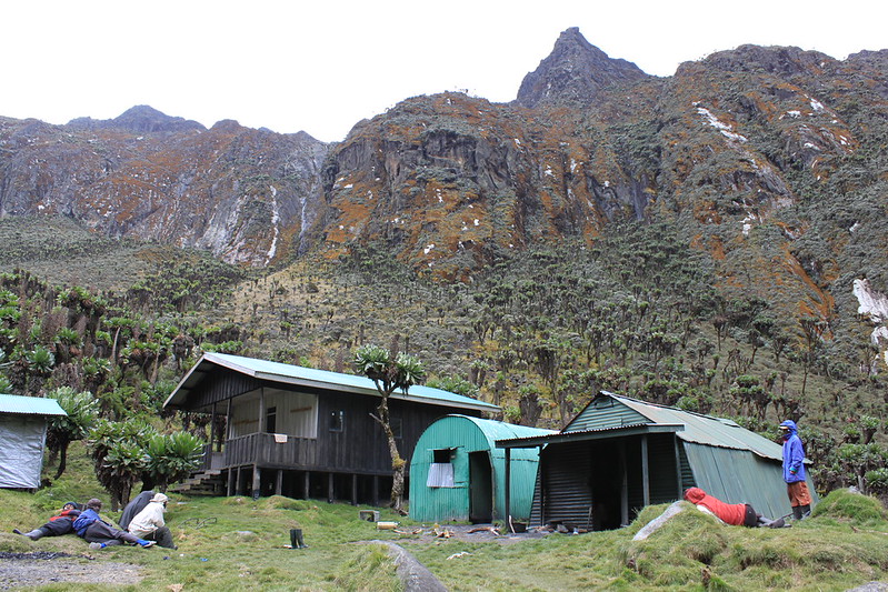
The 5-Day Rwenzori Trek to Bujuku Hut follows the Central Circuit Trail, the oldest and most established route through Rwenzori Mountains National Park, climbing from the Nyakalengija trailhead at 1,615 meters to Bujuku Hut at roughly 3,962 meters, a rise of well over two vertical kilometers, achieved on foot, through five distinct ecological worlds. Along the way, the trail passes through dense montane rainforest, a green tunnel of alpine bamboo, moss-hung giant heather forest, and finally the boggy, otherworldly Afro-alpine moorland that surrounds Bujuku Valley itself.
This is a challenging trek, five consecutive days of genuine physical effort, muddy trail, and high-altitude exertion, but it is not a technical one. No glacier travel, ropes, or climbing movement is involved at any stage. That distinction makes this 5-day Bujuku Hut Rwenzori trekking itinerary the choice for travelers who want the full drama of the Rwenzori Mountains, giant lobelias, alpine lakes, and Mount Stanley, Mount Speke, and Mount Baker rising together above the valley floor without committing to a full Margherita Peak summit expedition.
It is designed for strong, motivated hikers rather than complete beginners: nature enthusiasts, photographers, and travelers seeking a serious high-altitude adventure on a supported, fully private itinerary. What follows is the most complete planning resource available for this specific trek: logistics, terrain, wildlife, weather, and the honest physical reality of five days walking into one of Africa’s most spectacular mountain landscapes.
Quick Summary For 5-Day Bujuku Hut Rwenzori Trek
Duration | 5 Days / 4 Nights |
Route | Central Circuit Trail |
Destination | Bujuku Hut, Rwenzori Mountains National Park |
Highest Elevation | Bujuku Hut, approximately 3,962 m (verify current figure before publishing; sources range 3,960–3,977 m) |
Difficulty | Challenging |
Accommodation | Mountain huts (Nyabitaba, John Matte, Bujuku) |
Best Time | Generally drier during December–February and June–August (weather remains unpredictable year-round) |
Starting Point | Nyakalengija (1,615 m) |
Trek Style | Out-and-back, private guided trek |
Ideal For | Fit hikers, photographers, and nature enthusiasts seeking high-altitude scenery without a summit ascent |
Why Choose the 5-Day Bujuku Hut Rwenri Trek
Not every traveler can commit to the 6-day Rwenzori Central Circuit trek or the 7-day Rwenzori Central Circuit’s technical preparation and glacier hike that a Margherita Peak summit demands. This 5-day Rwenzori Trek to Bujuku Camp itinerary exists precisely for that reason; it delivers the Central Circuit’s signature experience in a shorter, more accessible window.
- The classic Central Circuit trail experience: the same route, huts, and landscapes used by summit expeditions for the first three days of the journey.
- Excellent high-altitude scenery: giant lobelia gardens, tussock moorland, and mist-wrapped ridgelines that define the Rwenzori’s most photographed terrain.
- The famous Bujuku Valley: widely considered the single most spectacular setting on the entire Central Circuit.
- Views of Mount Stanley, Mount Speke, and Mount Baker: all three massifs are visible together from camp, a vantage point few other locations in the range can match.
- Giant lobelias and giant groundsels are reliably encountered in the Afro-alpine zone surrounding Bujuku, among the Rwenzori’s most iconic botanical residents.
- Alpine lakes: Lake Bujuku itself, a still, glacially fed lake framed by rock and moorland.
- High mountain photography: dawn and dusk light on three glaciated peaks simultaneously, a genuinely rare composition.
- A rewarding challenge without a summit ascent: five demanding days that test your fitness and reward your effort, without the added risk, cost, and preparation of technical glacier travel.
Who Is This Trek For?
This itinerary rewards a specific kind of traveler, so it’s worth being clear about who it suits and who it doesn’t.
- Strong hikers: capable of five consecutive days averaging five to seven hours of hiking, including one notably long descent day.
- Nature enthusiasts: drawn to a landscape sequence found in almost no other trekking destination on Earth.
- Wildlife lovers: eager to encounter wildlife on its own terms in dense forests and high moorland.
- Photographers: seeking mountain light and Afro-alpine botanical subjects rarely captured elsewhere.
- Travelers seeking high-altitude adventure without technical climbing: wanting genuine high-altitude adventure, cold nights, thin air, and dramatic scenery without ropes or crampons.
- Private groups: This itinerary runs as a fully private, custom-scheduled trek for parties of any size.
- Families with experienced teenage hikers: experienced, physically well-prepared teenagers can undertake this trek; younger children are not recommended given the sustained daily effort.
- Luxury and mid-range travelers: This trek is fully supported with private guides, porters, and hut accommodation suited to travelers who value comfort within the constraints the mountain itself imposes.
Who Should Consider a Shorter 5-day Rwenzori Trek to Bujuku?
Travelers with limited time, more modest fitness, or a preference for lower-altitude scenery may find our 3-Day Lake Mahoma Trek or 4-Day John Matte Hut Trek a better fit, as both offer genuine Rwenzori forest and lower-montane experiences without the altitude or physical demands of the Bujuku Valley.
Introducing Bujuku Hut
Bujuku Hut sits at the emotional and geographical center of the Central Circuit Trail, at the edge of Bujuku Valley, a broad, boggy, high-altitude basin enclosed on three sides by Mount Stanley, Mount Speke, and Mount Baker. Few points anywhere in the Rwenzori offer a comparable vantage point of three major massifs at once.

- Position on the Central Circuit: the fourth overnight camp in the standard Central Circuit sequence from Nyakalengija, reached after Nyabitaba and John Matte.
- Role as a staging camp: Nyabitaba is the principal staging camp for travelers continuing toward Elena Hut and Mount Stanley’s summit glacier, as well as those attempting Mount Speke, making it one of the most consequential huts on the entire route, whether or not your itinerary continues beyond it.
- Surrounding landscape: tussock moorland, bog, and rock, with giant groundsels standing sentinel across the valley floor and the three peaks visible in clear conditions.
- Nearby Bujuku Lake: a short walk from the hut, the still, glacially fed alpine lake offers some of the most tranquil scenery on the entire trek, particularly in the calm light of early morning.
- Typical views from the hut: on clear mornings, the hut looks directly onto the glaciated flanks of Mount Stanley and Mount Speke, with Mount Baker visible along the valley’s opposite ridge, a view that has drawn photographers and mountaineers alike for over a century.
The Central Circuit Trail: Route Context
The Central Circuit Trail begins at Nyakalengija (1,615m), home to the Rwenzori Mountaineering Services offices, and is the oldest, most established trekking route through Rwenzori Mountains National Park.
- Starting point: Nyakalengija, at the edge of farmland bordering the park boundary.
- Major camps on this itinerary include Nyabitaba (2,651 m), John Matte (3,414 m), and Bujuku (3,962 m); the full circuit continues to Elena, Kitandara, and Guy Yeoman huts for summit-bound parties.
- Rivers crossed: the Mubuku River accompanies much of the lower trail, and the Bujuku River is crossed via engineered footbridges between Nyabitaba and John Matte.
- Valleys: the trail follows the Mubuku Valley through the lower forest before opening into the Bujuku Valley at the circuit’s heart.
- Vegetation zones traversed: montane forest, bamboo forest, heather forest, and Afro-alpine moorland, each with its own climate, plant community, and character underfoot.
- Scenic highlights: the Kurt Schafer Bridge crossing, the bamboo tunnel, the moss-draped heather forest, the Lower and Upper Bigo Bogs, and the valley’s dramatic final approach.
The trail reaches Bujuku Valley by climbing steadily through each vegetation zone in turn, crossing the notorious Bigo Bog boardwalks before the terrain opens out and the valley’s three guardian peaks come into view, the payoff for three days of accumulating altitude and effort.
Day-by-Day Itinerary For 5-Day Rwenzori Trek to Bujuku Hut
DAY 1: Nyakalengija to Nyabitaba HutMontane forest, first river crossings, first birdsong |
DISTANCE ~7 km | HIKING TIME 5–7 hrs | ELEVATION 1,615m → 2,651m | ZONE Montane Forest |
Your private vehicle collects you in Kasese in the early morning and delivers you to Nyakalengija, where your guide and porter team are already waiting at the Rwenzori Mountaineering Services headquarters. Permits checked, packs distributed, and boots laced. The mountain begins almost immediately, the trail slipping from farmland into dense forest within the first half hour.
The path follows close along the Mubuku River, crossing a tributary of the Mahoma before climbing steadily beneath a canopy strung with vines and moss. Somewhere in the trees above, chimpanzee calls carry down the valley; blue monkeys move through the middle canopy with unhurried confidence, and black-and-white colobus watch from higher branches with the particular stillness of an animal that knows it has already been seen. The unmistakable, croaking call of the Rwenzori turaco announces itself long before the bird does.
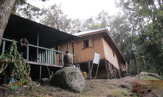
The final stretch is the day’s honest test: a long, steep pull up bracken-covered slopes onto the forested ridge where Nyabitaba Hut waits at 2,651 meters. Dinner is simple and warming, eaten with the particular satisfaction of a first day’s effort behind you, and the forest settles into the kind of complete darkness only high mountains provide.
DAY 2: Nyabitaba to John Matte HutBridge crossings, bamboo forests, and the first giant heather |
DISTANCE ~9 km | HIKING TIME 6–7 hrs | ELEVATION 2,651m → 3,414m | ZONE Bamboo & Lower Heather |
Morning at Nyabitaba brings the day’s first engineering feature: the crossing of the Bujuku River via the Kurt Schafer Bridge, a suspended span that sways gently underfoot above the rushing water below, a small thrill that marks the transition into wilder country.
Beyond the bridge, the forest changes character entirely. Giant alpine bamboo (Yushania alpina) closes overhead into a dense green tunnel, its jointed stems creaking in the wind, its thick leaf litter muffling every footstep. The ground grows rootier and muddier here, and gaiters earn their place in your pack. As the trail climbs, bamboo gradually gives way to the first gnarled specimens of giant heather, their branches already beginning to gather the moss and lichen that will define the zone above.
John Matte Hut appears at 3,414 meters, perched above the Bujuku River and wrapped in heather hung with pale, trailing lichens. This location is often where trekkers first notice the quieter effects of altitude: a slightly reduced appetite and a touch more effort in ordinary movement. This phenomenon is entirely normal and is exactly why your guide has kept today’s pace unhurried rather than rushed.
DAY 3: John Matte to Bujuku HutThe Bigo Bogs, giant lobelias, and the peaks arrive |
DISTANCE ~7 km | HIKING TIME 5–6 hrs | ELEVATION 3,414m → 3,962m | ZONE Afro-alpine Moorland |
This is the day the Rwenzori reveals its stranger, more alien character. A short descent from John Matte brings you to another crossing of the Bujuku River and then directly into the Lower Bigo Bog, a vast, waterlogged basin where giant lobelias stand three to four meters tall among the tussock grass, their spike-like flower stems rising like something from a different geological age entirely. A wooden boardwalk threads through the worst of the mud, though wet boots by this point are less a risk than a formality.
The trail continues through the Upper Bigo Bog, past the rock shelter known locally as Cooking Pot, with Mount Speke’s ridgeline appearing intermittently through drifting clouds. Then, without much warning, the valley opens fully: Mount Stanley, Mount Speke, and Mount Baker arrive together in the same field of view, ringed around Bujuku Valley’s boggy floor, and Bujuku Hut sits waiting at the valley’s edge at roughly 3,962 meters.
The afternoon is yours to spend as the mountain allows. Most trekkers walk the short distance to Lake Bujuku’s shore, where the water sits so still it holds a near-perfect reflection of the surrounding peaks on calm mornings, or wander among the giant groundsel gardens scattered across the valley floor. This scene is, for most travelers on this itinerary, the single image they carry home from the Rwenzori, and it is reached entirely on foot, without a rope in sight.
DAY 4: Bujuku Hut to Nyabitaba HutRetracing the bogs and bamboo, in reverse and in new light |
DISTANCE ~16 km | HIKING TIME 8–9 hrs | ELEVATION 3,962m → 2,651m | ZONE Moorland to Montane Forest |
Today asks the most of your legs, if not your lungs: a long, sustained descent that retraces two days of ascent in a single push, covering the ground back through the Bigo bogs, past John Matte, and down through the bamboo tunnel to Nyabitaba. Descending is its own particular effort, with different muscles, different balance, and a different relationship with the mud underfoot, and your guide sets a pace that respects weary legs rather than racing against the daylight.
There is real value in seeing this terrain a second time, moving the other direction: details missed on the climb, a particular giant groundsel silhouette, and the exact angle at which Speke’s ridge catches the afternoon light reveal themselves on the way back down. By the time Nyabitaba’s forested ridge reappears, familiar now rather than novel, there is a distinct sense of a circuit closing rather than simply retreating.
Dinner at Nyabitaba on this final night carries a different tone from your first night here: the satisfaction of distance covered, valley reached, and peaks seen, with only a single easy day remaining.
DAY 5: Nyabitaba to NyakalengijaFarewell to the forest; private transfer to Kasese |
DISTANCE ~7 km | HIKING TIME 4–5 hrs | ELEVATION 2,651m → 1,615m | ZONE Montane Forest |
The final morning is a gentle one by comparison: a steady descent back through the same forest that opened this journey five days ago, though it feels different now, familiar, almost companionable, rather than unknown. Blue monkeys and colobus make their usual appearances, and the Mubuku River accompanies you most of the way back to the park boundary.

At Nyakalengija, your guide and porter team walk you the final steps to park headquarters, where farewells are warm and unhurried rather than rushed. Your private vehicle is waiting for the transfer back to Kasese, where a hot shower, a proper bed, and the particular stillness that follows five days on a mountain await.
Inclusions and Exclusions Of the 5-day Rwenzori Trek to Bujuku Hut
Typical Inclusions
- Rwenzori Mountains National Park entry.
- Professional licensed guide: throughout the trek.
- Porters: allocated according to group size and equipment needs.
- Accommodation: mountain huts at Nyabitaba, John Matte, and Bujuku.
- Meals: all meals from Day 1 dinner through Day 5 breakfast.
- Drinking water arrangements: treated mountain water throughout the trek.
- Transfers: private vehicle service between Kasese and Nyakalengija.
Typical Exclusions
- International flights: to and from Uganda.
- Uganda visa: entry visa fees.
- Travel insurance: including high-altitude and evacuation coverage.
- Personal trekking equipment: boots, clothing, sleeping bag, and other items detailed in our Equipment Guide.
- Tips for guides, porters, and cooks are customary but not obligatory.
- Alcoholic beverages: typically unavailable on the mountain.
- Personal expenses: souvenirs, additional snacks, and similar costs.
Experience Rwenzori Beyond Expectations
Spots Filling Fast — Schedule Your Trek Today
How the Landscape Changes Along the Way
This 5-day Rwenzori trek to Bujuku Hut packs an extraordinary ecological range into just five days of walking.
Zone | Approx. Altitude | Character on This Trek |
Montane Rainforest | 1,615 – 2,651 m | Dense canopy, rivers, first primates and birdlife (Days 1 & 5) |
Bamboo Forest | 2,651 – ~3,000 m | Green tunnel of Yushania alpina, muddy underfoot (Day 2) |
Heather Zone | ~3,000 – 3,414 m | Moss- and lichen-draped giant heather, first bogs (Day 2) |
Afro-Alpine Moorland | 3,414 – 3,962 m | Bigo Bogs, giant lobelias, Bujuku Valley itself (Days 3–4) |
Alpine Lake & Valley Floor | ~3,962 m | Lake Bujuku, giant groundsel gardens, peak views (Day 3 afternoon) |
Wildlife Along the Route
Wildlife density follows the same pattern found across the range: highest in the lower forest and progressively sparser, though arguably more improbable, as altitude increases.
Habitat / Day | Wildlife You May Encounter |
Montane Forest (Days 1 & 5) | Black-and-white colobus, blue monkeys, Rwenzori turaco, chimpanzee calls |
Bamboo & Heather (Day 2) | Sunbirds, duikers, chameleons, forest birdlife |
Afro-Alpine Moorland (Days 3–4) | Albertine Rift endemic birds, cold-adapted insects around lobelia stands, |
Lake Bujuku Environs | Occasional wading birds, giant groundsel-associated insect life |
Set realistic expectations: this trip is not a wildlife safari, and sightings, particularly of mammals, are opportunistic rather than guaranteed. The birdlife, however, is genuinely rewarding for anyone willing to move quietly and look up.
Physical Challenge
- Daily hiking hours: ranging from four to nine hours depending on the day, with Day 4’s long descent the most physically taxing stage of the entire itinerary.
- Trail conditions: root-strewn and slick in the forest, deeply muddy through the bamboo and bog sections, and rocky underfoot on the final approach to Bujuku.
- Mud: expect it, particularly through the Lower and Upper Bigo Bogs; this is one of the most reliably muddy stretches of trail in East African trekking.
- Boardwalk sections: wooden boardwalks cover the worst bog sections but are themselves often slick and uneven, requiring careful footing rather than casual walking.
- River crossings: multiple footbridge crossings of the Mubuku and Bujuku Rivers present no technical difficulty but do require steady footing and full attention.
- Steep ascents: the climb from Nyabitaba to John Matte and the initial pull up from Nyakalengija are the trip’s steepest sustained sections.
- Altitude: Reaching nearly 3,962 meters over three days of ascent means genuine altitude effects are a realistic, normal part of this trek, not a remote possibility.
Acclimatization
Altitude, not distance, is usually what determines how comfortable or uncomfortable this 5-day Rwenzori trek to Bujuku hut feels.
- Importance of gradual ascent: this itinerary’s staged ascent through Nyabitaba, John Matte, and Bujuku follows the same graduated altitude gain used on our longer summit itineraries, giving your body a chance to adjust in stages rather than all at once.
- Hydration: drink more water than feels necessary; dehydration compounds altitude symptoms and is one of the most preventable contributors to a difficult trek.
- Pace: The Swahili trekking principle “pole pole”—slowly, slowly—applies here as much as on any Rwenzori route; your guide’s measured pace above 3,000 meters is a deliberate choice, not a lack of urgency.
- Recognizing altitude illness: mild headache, reduced appetite, and slightly labored breathing are common and generally normal; persistent worsening symptoms, confusion, or loss of coordination are not and should be reported to your guide immediately.
AN HONEST NOTE ON PACEBecause this trip is a compact 5-day Bujuku Rwenzori trekking itinerary rather than a longer, more gradually staged expedition, it demands solid baseline fitness and offers less acclimatization buffer than our 6-day or 7-day Margherita Peak itineraries. Travelers with particular concern about altitude, or wanting a more gradual ascent profile, may prefer to speak with us about those longer options. |
Equipment Guide
- Waterproof boots: the Bigo Bogs and forest sections are inherently wet, so leather or synthetic boots with genuine waterproofing, already broken in before you arrive, prevent the single most common source of trek-ending blisters.
- Rain gear: rain is a near-daily probability at some point on this route regardless of season; a proper waterproof jacket and trousers, not merely water-resistant, are essential rather than optional.
- Warm layers: night temperatures at Bujuku commonly fall to 0–5°C, and layering allows you to adjust through a single day’s swing from warm valley walking to cold, damp evenings at altitude.
- Trekking poles: the muddy, root-strewn, and occasionally steep terrain rewards the extra stability poles provide, particularly on the long Day 4 descent.
- Headlamp: huts have limited or no lighting after dark, and early starts on longer days require reliable hands-free light.
- Gloves: cold mornings and evenings at altitude make these more than a comfort item; frostbite risk is low, but finger dexterity in the cold matters for camp tasks and photography alike.
- Daypack: for carrying layers, water, camera equipment, and snacks accessible during the day, separate from your main kit, which is carried by porters.
- Sleeping bag: a bag rated to at least 0°C (with margin for a colder-than-expected night) is essential, as hut sleeping platforms offer no heating of their own.
Weather
Rwenzori weather is genuinely changeable, and this itinerary should be planned with that reality in mind rather than an expectation of guaranteed clear skies.
- Rainfall: heavy and frequent across all five days, with little true dry season by lowland East African standards.
- Temperature: warm and humid in the lower forest, falling to near-freezing or below at Bujuku overnight.
- Fog: a near-constant presence above 3,000 meters, often settling in by early afternoon even during the drier trekking windows.
- Wind: can be sharp and cold across the exposed moorland approaching Bujuku Valley, adding meaningful windchill on ridge sections.
- Seasonal changes: the two drier windows bring somewhat reduced rainfall and improved visibility, but conditions remain genuinely variable in any month of the year.
We do not promise clear weather on any specific day of this trek; no honest operator can, but we do promise a guide team experienced at making the most of whatever conditions the mountain provides.
Best Time to Trek
Uganda’s two relatively drier trekking windows, roughly December to February and June to August, offer the firmest trail conditions and best odds of clear views into Bujuku Valley, though the Rwenzori’s weather remains unpredictable in any month, and travelers should plan accordingly rather than expecting guarantees.
- Drier seasons: the two windows above see somewhat reduced rainfall and firmer footing, particularly through the notorious Bigo Bog sections.
- Wetter seasons: outside these windows, expect deeper mud and a higher likelihood of sustained rain, though the trek remains entirely feasible with proper equipment and expectations.
- Photography: clear dry-season mornings offer the best odds of capturing all three peaks in a single frame from Bujuku; clouds typically build through the afternoon regardless of season.
- Wildlife viewing: Wildlife activity in the lower forest is consistently rewarding throughout the year, giving flexible timing to travelers whose priority is biodiversity over mountain views.
Safety
- Altitude: genuine altitude effects are a normal part of reaching nearly 3,962 meters; your guide monitors for warning signs and will adjust pace or, if necessary, descend.
- Slippery trails: wet roots, rock, and boardwalk sections require careful, deliberate footing throughout the trek, particularly on descent days.
- River crossings: multiple footbridge crossings are safe when following your guide’s instructions but should never be rushed or treated casually.
- Cold temperatures: night and early-morning conditions at Bujuku demand proper cold-weather layering; hypothermia risk is real without adequate gear.
- Emergency procedures: our guide teams carry first-aid supplies and maintain communication protocols with park authorities; evacuation procedures exist for serious incidents, which is precisely why comprehensive travel insurance is required for this trek.
- Role of guides and porters: Licensed guides and experienced porters are not a formality but a genuine safety layer, route knowledge, weather judgment, and altitude monitoring that no amount of independent preparation can replace.
Conservation
Every step of this trek takes place within Rwenzori Mountains National Park, a UNESCO World Heritage Site inscribed in 1994 for its exceptional natural beauty and outstanding biodiversity value.
- UNESCO World Heritage status: this recognition reflects landscapes and species found in only a handful of comparable locations on Earth, the Bujuku Valley being among the most striking examples within the park.
- Uganda Wildlife Authority management: the Uganda Wildlife Authority manages the park’s permits, ranger patrols, and hut infrastructure and enforces the regulations that keep this fragile environment intact for future trekkers.
- Responsible trekking: stay on marked trails and boardwalks, particularly through the boggy Afro-alpine sections, where off-trail trampling damages slow-growing moss and peat that can take decades to recover.
- Leave No Trace principles: carry out everything you carry in; biodegradable waste decomposes far more slowly in the cold, wet conditions above 3,000 meters than at lower altitudes.
- Protecting fragile alpine vegetation: giant lobelias and groundsels are slow-growing and easily damaged; admire and photograph them without touching or approaching too closely.
Practical Planning Information
- Park permits: Uganda Wildlife Authority permits are mandatory and arranged as part of your booking with us.
- Guide requirements: a licensed guide is required by park regulation and included in every itinerary we run.
- Porter services: Porters are arranged according to group size and personal equipment needs and are strongly recommended given the terrain.
- Accommodation: UWA-maintained mountain huts at Nyabitaba, John Matte, and Bujuku, with basic sleeping platforms rather than beds.
- Meals: hot cooked meals prepared by your trek cook at each hut, plus packed lunches for trail days.
- Transport: A private vehicle transfer between Kasese and the Nyakalengija trailhead is included.
- Group size: This itinerary runs as a fully private trek for parties of any size, from solo travelers to small groups.
- Age recommendations: suited to fit adults and experienced, well-prepared teenagers; not recommended for young children.
- Travel insurance: comprehensive coverage, including high-altitude trekking and emergency evacuation, is required for all trekkers.
- Fitness preparation: regular cardiovascular training and, ideally, multi-day hiking experience in the months before departure meaningfully improve your experience on this trek.
Experience Rwenzori Beyond Expectations
Spots Filling Fast — Schedule Your Trek Today
Frequently Asked Questions: 5-day Rwenzori trek to Bujuku Hut
Bujuku Hut sits at approximately 3,962 meters above sea level, with published sources placing it between roughly 3,960 and 3,977 meters, a fittingly Rwenzori-esque discrepancy. We recommend verifying against current Uganda Wildlife Authority documentation before finalizing travel plans.
This trek suits fit, motivated beginners rather than complete first-time hikers. No technical climbing skill is required, but multiple consecutive days of five to seven hours of hiking over muddy, uneven, and occasionally steep terrain call for genuine baseline fitness and mental readiness for sustained discomfort.
For most travelers who ask this question, yes, Bujuku Valley is widely regarded as the single most photogenic setting on the entire Central Circuit trail, framed by Mount Stanley, Mount Speke, and Mount Baker simultaneously, without requiring the technical glacier travel that a summit attempt demands.
We rate it Challenging: five consecutive days of demanding terrain, including notorious bog sections, steep forested ascents, and a long descent day, but without ropes, crampons, or technical climbing movement of any kind.
Blue monkeys, black-and-white colobus, and the Rwenzori turaco are realistic sightings in the lower forest; higher up, expect birdlife rather than mammals, with sightings becoming progressively less frequent, though no less rewarding, as altitude increases.
The two drier windows, roughly December to February and June to August, offer firmer trail conditions and clearer mountain views, though the Rwenzori’s weather remains genuinely unpredictable in any month.
Night temperatures at Bujuku commonly fall to somewhere between 0°C and 5°C, and windchill can make it feel colder still; a properly rated sleeping system and warm layers are essential rather than optional
Yes. Uganda Wildlife Authority regulations require a licensed guide for all treks within Rwenzori Mountains National Park, and we consider porters equally indispensable given the terrain
Waterproof boots, full rain protection, warm insulating layers, gloves, a headlamp, trekking poles, and a rated sleeping bag are the non-negotiables; see our full Equipment Guide section below for the reasoning behind each.
Yes, Bujuku Hut is the standard staging point for summit attempts on Mount Stanley, and this itinerary can be extended by adding Elena Hut, the glacier crossing, and the return via Kitandara. Speak with us about our 6-day and 7-day Margherita Peak itineraries if a summit interests you.
Prior multi-day hiking experience is strongly recommended, though not strictly mandatory. What matters more is honest self-assessment of your current fitness and your tolerance for sustained physical effort in cold, wet conditions.
Between five and nine hours of active hiking per day, varying by stage, the descent day in particular runs long, since it retraces two days’ distance in one.
Some mild symptoms, headache, reduced appetite, and slight breathlessness, are common and generally normal above 3,000 meters. Our guides are trained to monitor for warning signs of more serious altitude illness and will adjust pace or descend if needed.
A still, often mist-wrapped alpine lake sitting at the edge of Bujuku Valley, ringed by giant groundsels and framed by the three surrounding peaks, is one of the most quietly spectacular spots on the entire Central Circuit trail.
Yes, notoriously so, particularly through the Lower and Upper Bigo Bogs between John Matte and Bujuku. Boardwalks cover the worst sections, but wet boots are close to a certainty at some point on this trek.
Yes, several bridge crossings over the Mubuku and Bujuku Rivers, including engineered footbridges, are part of the standard route and present no special technical difficulty when following your guide’s lead.
UWA-maintained mountain huts at Nyabitaba, John Matte, and Bujuku are solid, basic wooden structures with sleeping platforms, rather than tents, though bedding and full creature comforts should not be expected.
It can suit families with experienced, physically prepared teenage hikers but is not recommended for young children given the sustained daily effort and cold, remote overnight conditions.
Group size determines exact numbers, but every trekking party is assigned a licensed guide at minimum, with porters allocated according to group size and personal equipment needs; we confirm exact staffing during itinerary planning.
We run this 5-day Bujuku Hut Rwenzori Trekking itinerary for private groups of any size, from solo travelers to small private parties, rather than mixing you into a fixed departure date with strangers.
Yes, comprehensive travel insurance covering high-altitude trekking and emergency evacuation is a requirement for this trek, not merely a recommendation.
Uganda Wildlife Authority park entrance permits and trekking permits are mandatory and are arranged as part of your booking; independent, unpermitted trekking within the park is not possible.
You will see Mount Stanley, Mount Speke, and Mount Baker at close range from Bujuku Valley itself, though this itinerary does not include summit ascents of any of them.
Yes, provided you are accompanied by your assigned licensed guide and, typically, at least one porter, solo trekking without any support staff is not permitted within the park.
Almost universally, trekkers cite the first unobstructed view into Bujuku Valley on Day 3, the moment all three peaks appear together above the giant groundsel gardens, as the trip’s defining memory.
No, this 5-day Bujuku Hut Rwenzori trek itinerary shares its first three days with our Margherita Peak treks but turns around at Bujuku Hut rather than continuing to Elena Hut and the summit glacier.
Hot cooked meals prepared by your trek cook at each hut, plus packed lunches for trail days, hearty, calorie-dense food suited to the physical demands of high-altitude trekking.
Yes, water is drawn from mountain streams and treated according to safe drinking protocols by your guide and cook team throughout the trek.
Rain and clouds are close to a daily certainty somewhere on this route regardless of season; your guide may adjust pace, timing, or, in rare cases of genuinely dangerous conditions, the day’s plan itself, always prioritizing safety over schedule.
We arrange a private transfer from Kasese to Nyakalengija, the trailhead and Rwenzori Mountaineering Services headquarters, as part of your 5-day Bujuku Hut Rwenzori trekking itinerary.
Experience Rwenzori Beyond Expectations
Spots Filling Fast — Schedule Your Trek Today
Experience the Heart of the Rwenzori Mountains
A trek to Bujuku Hut takes you into one of the most spectacular landscapes in the Rwenzori Mountains National Park. From lush montane forests and giant heather to the breathtaking Bujuku Valley surrounded by towering peaks, this journey offers an unforgettable high-altitude adventure without the technical demands of a summit climb. Our experienced local guides will support you every step of the way, helping you enjoy the mountains safely while sharing their profound knowledge of the Rwenzori’s landscapes, wildlife, and history.
YOUR PATH TO BUJUKU VALLEY IS ALREADY BEING PLANNED You do not need to figure out permits, porters, or pacing on your own. Tell us your dates and your fitness level, and we will build a private itinerary around them, with every hut booking, every transfer, and every detail seamlessly arranged before you land in Uganda. Nothing is left to chance, from your first step at Nyakalengija to your last night’s sleep in Kasese; every decision is handled by guides who know this exact trail intimately. |
Experience Rwenzori Beyond Expectations