Geology of the Rwenzori Mountains—Discover how the Rwenzori Mountains formed through tectonic uplift in the Albertine Rift. Explore their geology, glaciers, rock formations, and how this unique landscape shapes the Rwenzori Mountains National Park as Africa’s most extraordinary trekking destinations.
The Rwenzori Mountains are not volcanoes. There is no crater at their summit, no cooled lava field beneath their glaciers, and no ash layered into their soil. Instead, the range that Ptolemy once called the Mountains of the Moon was built by a far slower and, in its own way, far more dramatic process: the earth’s crust splitting apart, and a single immense block of ancient rock being forced upward between the fractures. What trekkers walk across today, from the bamboo forests of the lower slopes to the glacier below Margherita Peak, is the exposed edge of that block, tilted, cracked, carved by rivers and ice, and still slowly rising.
This makes the Rwenzori Mountains one of the world’s most striking examples of a fault–block mountain range, geologically unrelated to Kilimanjaro, Mount Kenya, or the volcanoes of the Virunga chain, despite standing among them as one of Africa’s great peaks. Understanding this distinction is not merely academic. The Rwenzori Mountains’ geology is the direct cause of nearly everything a trekker experiences on its trails: the depth and steepness of its valleys, the boggy ground of its lower forests, the boulder fields of its higher circuits, the alpine lakes tucked into its cirques, and the fact that its summit still carries a small, fast-vanishing cap of equatorial ice. This page sets out, as plainly and accurately as the science allows, how that block mountain came to be and why it matters to anyone planning to walk across it.
Quick Facts
Mountain Type | Fault-block mountain (horst) |
Formation Process | Tectonic uplift along parallel faults |
Rift System | Albertine Rift: western branch of the East African Rift System |
Highest Peak | |
Main Rock Types | Gneiss, granite, amphibolite, quartzite (Precambrian basement) |
Approx. Basement Age | Roughly 2 billion years (Precambrian) |
Approx. Uplift Age | Chiefly within the last several million years (late Neogene–Quaternary) |
Volcanic? | No, the Rwenzori contain no craters, lava, or ash. |
UNESCO Status | World Heritage Site (inscribed 1994) |
What Is a Block Mountain?
To understand the Rwenzori Mountains, it helps to start with two basic ideas from geology: faults and tectonic plates. The Earth’s outer shell is broken into large, rigid plates that drift slowly over the softer rock beneath them, driven by heat escaping from the planet’s interior. Where plates pull apart, stretch, or collide, the crust cracks along lines of weakness called faults. A fault is simply a fracture in rock along which one side has moved relative to the other, sometimes by centimeters, sometimes by kilometers, and sometimes over millions of years of accumulated small movements.
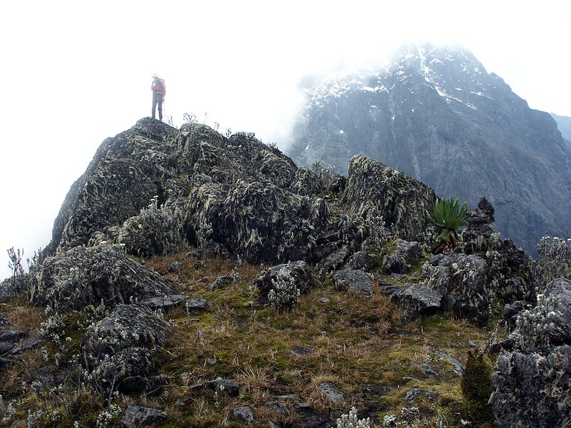
When a section of crust lies between two roughly parallel faults, one of two things can happen as the surrounding land stretches. If the block between the faults drops relative to its surroundings, geologists call it a graben, and this is exactly how most of the Albertine Rift’s valley floors, and the lakes that fill them, came to exist. If, instead, the block between the faults stays in place or is pushed upward while the land on either side subsides, it is called a horst, and this is precisely what happened to the Rwenzori. The mountain did not grow upward the way a volcano does, by accumulating erupted material layer upon layer. It was already there, as part of the ancient basement rock of the African continent, and it simply stayed elevated, or was actively pushed higher, while the ground around it sank. Trekkers sometimes describe the range as looking like a broken tooth standing above the rift floor; that description is closer to the geological truth than most casual comparisons to a volcanic cone.
Formation of the Rwenzori Mountains
The Rwenzori Mountains’s story begins far earlier than the mountain itself. The rock that now forms its peaks, principally gneiss, quartzite, granite, and amphibolite, crystallised deep within the Earth’s crust roughly two billion years ago, during the Precambrian eon, long before complex life existed anywhere on the planet. For most of the time since, this rock sat as part of the stable basement of the African continent, buried under younger sediment, entirely unremarkable and completely flat by comparison to what it would become.
The transformation began with the opening of the East African Rift System, a process that started tens of millions of years ago as tectonic forces began to stretch and thin the crust beneath eastern and central Africa. Along the rift’s western branch, now known as the Albertine Rift, this stretching created the parallel fault systems that would eventually define the Rwenzori’s edges. As the crust extended, the land on either side of the future mountain began to subside, forming the basins that today hold Lake Albert to the north and Lake Edward and Lake George to the south. The block of ancient basement rock caught between these subsiding basins had nowhere to go but up, both through active tectonic uplift and through a related process called isostatic rebound, in which a block of crust rises as erosion strips weight from its surface, in something like a cork bobbing upward as pressure on it is released.
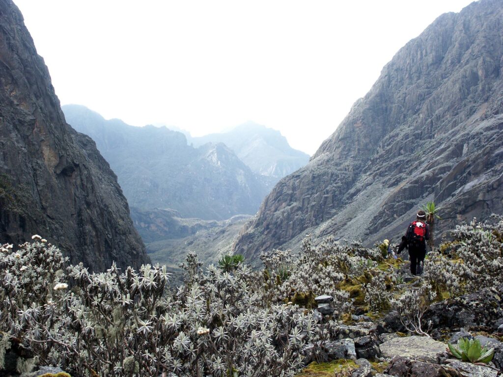
Geological dating places the most significant phase of this uplift within roughly the last several million years, a comparatively recent event by the standards of the two-billion-year-old rock involved, though the deeper structural history of the range, revealed through thermochronology studies, shows a far more complex, multi-stage cooling and exhumation history stretching back tens of millions of years in places. As the block rose, rivers draining its flanks began cutting downward into the rising rock, carving the deep, steep-sided valleys that make Rwenzori trekking routes so demanding today. During cooler climatic periods over the last few million years, glaciers formed on the range’s highest points and carved much of the alpine scenery, cirques, U-shaped valleys, and moraine ridges, that trekkers now walk through on the approach to Margherita Peak. Weathering, landslides, and river erosion continue to modify the landscape today, meaning the mountain a trekker climbs is not a finished object but a landscape still visibly, and in places rapidly, changing.
The East African Rift System
The Rwenzori cannot be understood in isolation from the East African Rift System, the vast network of fractures running roughly north to south through eastern Africa, along which the continent is very slowly splitting into two separate plates: the larger Nubian Plate to the west and the smaller Somali Plate to the east. The rift divides into an eastern branch, which runs through Ethiopia, Kenya, and Tanzania and hosts most of the region’s famous volcanoes, including Kilimanjaro and Mount Kenya, and a western branch, the Albertine Rift, which arcs through Uganda, the Democratic Republic of the Congo, Rwanda, and Burundi.
The Rwenzori sit directly within this western branch, wedged between the rift’s bounding faults along the Uganda–DRC border. Unlike the eastern branch, where rifting has been accompanied by extensive volcanic activity, the Albertine Rift has produced comparatively little volcanism along the specific section that includes the Rwenzori, which is precisely why the range’s exposed rock is ancient basement material rather than young volcanic stone. Rifting in this region is an ongoing process rather than a historical event: minor seismic activity, hot springs, and continuing subsidence in the surrounding valleys all indicate that the tectonic forces which raised the Rwenzori remain active today, even if their effects unfold on a timescale far beyond a single human lifetime.
Why the Rwenzori Are Not Volcanic
Because Kilimanjaro and Mount Kenya dominate the popular image of East Africa’s great mountains, many travellers arrive in Uganda assuming the Rwenzori shares the same volcanic origin. It does not, and the distinction shapes almost everything about the trekking experience, from the composition of the ground underfoot to the shape of the peaks themselves.
Feature | Rwenzori Mountains | Mount Kilimanjaro |
Origin | Tectonic uplift (faulting) | Volcanic eruption |
Rock Type | Metamorphic & igneous basement (gneiss, quartzite, granite, amphibolite) | Layered volcanic lava and ash |
Crater | None | Yes, Kibo’s summit crater. |
Formation Mechanism | Fault-block (horst) uplift between rift faults | Successive volcanic eruptions building a cone |
Approx. Age of Summit Rock | ~2 billion years (basement), uplifted in the last few million years | Under 1 million years |
Typical Trekking Terrain | Bogs, boulder fields, glacial valleys, exposed rock ridges | Volcanic scree, ash slopes, cinder cones |
The practical consequence for trekkers is straightforward: where a Kilimanjaro climb moves across successive layers of ash, cinder, and lava on the gradual slopes of a single cone, a Rwenzori trek moves across ancient, hard basement rock exposed and sculpted by faulting, glaciation, and river erosion, terrain that tends to be steeper, more broken, and considerably more technical underfoot.
Rock Types of the Rwenzori
The Rwenzori’s basement is dominated by four principal rock types, each of which leaves its own signature on the landscape trekkers pass through.
Rock Type | How It Formed | Where Trekkers See It |
Gneiss | Ancient sedimentary and igneous rock recrystallised under extreme heat and pressure deep in the crust | Exposed ridgelines and rock faces across the Central Circuit’s upper sections |
Quartzite | Metamorphosed sandstone, extremely hard and erosion-resistant | Forms many of the range’s sharp peaks and resistant cliff bands |
Amphibolite | Metamorphosed basalt or gabbro, dark and dense | Darker rock bands visible in valley walls and stream beds |
Granite & granitic gneiss | Cooled slowly from molten rock deep underground, later exposed by uplift and erosion | Boulder fields and glacially polished outcrops near the higher camps |
Because these rocks are hard and metamorphic rather than soft volcanic ash, Rwenzori trails tend to feature exposed rock scrambles and boulder-strewn sections rather than the loose scree familiar from volcanic peaks, a distinction worth bearing in mind when comparing the physical demands of a Rwenzori trek to those of Kilimanjaro or Mount Kenya.
How Glaciers Shaped the Mountains
During cooler phases of the last few hundred thousand years, and especially during the most recent glacial periods, the Rwenzori’s highest massifs supported glaciers vastly larger than the small remnants that survive today. As these ice masses moved slowly downhill under their own weight, they ground away at the underlying rock, gouging out the broad, flat-floored, steep-sided valleys known as U-shaped valleys, in contrast to the narrower V-shaped valleys typically carved by rivers alone. Where ice accumulated in bowl-shaped hollows near the peaks, it carved amphitheater-like depressions called cirques, several of which now cradle the range’s beautiful alpine tarns.
As glaciers advanced and retreated repeatedly over these cycles, they also deposited ridges of unsorted rock debris, known as moraines, marking the former limits of the ice. Many of the alpine lakes trekkers encounter along the Central Circuit and Kilembe routes, including those near Bujuku and the upper valleys beneath Mount Speke, occupy basins gouged by past glaciation or sit dammed behind ancient moraine ridges. Even where no ice remains today, the glacial fingerprint on the landscape, smoothed rock surfaces, U-shaped valley profiles, and moraine terraces, is unmistakable to a trained eye and visible even to first-time trekkers once they know what to look for.
Rivers and Waterfalls: Geology Shapes Hydrology
The same tectonic uplift that raised the Rwenzori also created the conditions for its role as one of the most important water catchments in the region. Heavy equatorial rainfall, intercepted by the range’s great height, feeds a dense network of rivers that originate high on the glaciated and snow-fed slopes and cut steeply downward through the uplifted rock toward the rift valley floor. Because the underlying rock is hard, resistant basement material rather than easily eroded sediment, rivers here tend to carve narrow, steep-walled valleys and produce dramatic waterfalls wherever they cross bands of particularly resistant rock or step down between fault-bounded terraces.
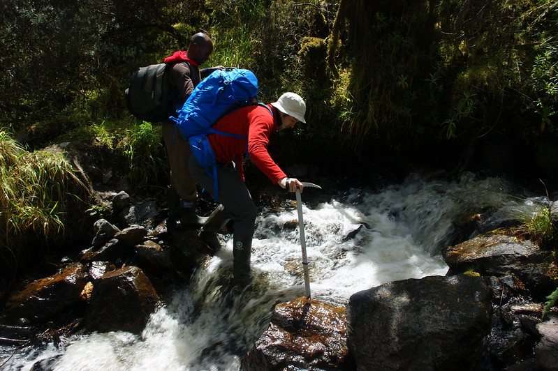
This hydrological role is not incidental to the range’s importance; it is central to it. The rivers draining the Rwenzori feed into Lakes Albert, Edward, and George, contributing meltwater and rainfall runoff to what is, ultimately, part of the wider Nile system, a connection that helped fuel two thousand years of speculation about the mountain’s role in the Nile’s source, discussed in detail in our companion page on the range’s history. For surrounding communities, these same rivers remain a vital source of water for agriculture and daily life, underscoring why the range’s geology and its human significance are inseparable.
Why the Landscape Is So Rugged
Every physically demanding feature of a Rwenzori trek can be traced back to the same underlying geological story. Tectonic uplift raised ancient, hard rock rapidly relative to its surroundings, giving rivers and glaciers a steep gradient to work with; erosion and glaciation then cut that uplifted block into ridges, valleys, and boulder fields rather than leaving it as a smooth dome. The result is a trekking landscape defined by dramatic knife-edge ridges, extensive fields of glacially deposited boulders, frequent river crossings where steep-sided valleys funnel meltwater and rainfall into fast-moving streams, and high alpine passes where trails must weave between rock outcrops rather than following a gentle gradient.
This is also part of why the Rwenzori has a reputation among experienced trekkers as one of the more physically serious treks in East Africa, distinct from the steady, predictable gradient of a volcanic ascent. Guides on both the Central Circuit and Kilembe Trail plan routes and pacing with this ruggedness explicitly in mind, which is one reason experienced local guiding, discussed further in our Central Circuit trail and Kilembe Trail guides, matters as much on this mountain as physical fitness alone.
How Geology Shapes Biodiversity
Geology’s influence on the Rwenzori Mountains extends well beyond scenery into the range’s celebrated biodiversity. The type and depth of soil formed by weathering basement rock, along with the range’s steep elevation gradient and highly localized drainage patterns, create a mosaic of distinct microclimates stacked one above another as altitude increases. This is a pivotal reason the Rwenzori Mountains supports five clearly defined vegetation zones within a single trek, from montane forest through bamboo and heather zones into afro-alpine moorland and finally bare rock and ice, each hosting different plant communities and, in turn, different wildlife.
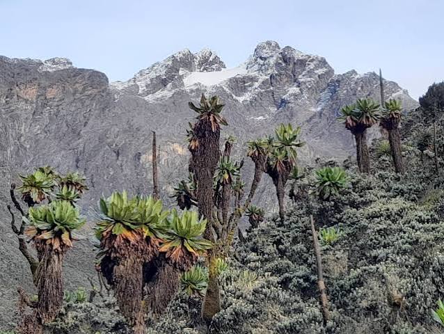
The giant lobelias, giant groundsels, and giant heathers that make the range’s afro-alpine zone so visually extraordinary are adapted specifically to the thin, well-drained, mineral-rich soils that form on weathered metamorphic rock at high altitude under intense equatorial sunlight and near-freezing nighttime temperatures, conditions found in very few other places on the planet. Understanding the geological basis for these zones adds considerable depth to a trek that might otherwise be experienced simply as a sequence of pretty but disconnected landscapes; readers interested in the ecological detail should see our dedicated Vegetation Zones and Flora guides.
Climate Change and the Glaciers
The Rwenzori’s glaciers are both a geological legacy and a rapidly disappearing feature. When the Duke of the Abruzzi’s expedition mapped the range in 1906, its glaciers covered an estimated 6.5 square kilometers across six separate peaks. By the 1950s, aerial surveys recorded roughly half that extent, and by the 1990s the ice had retreated to around 1.5 to 1.7 square kilometres, surviving on only three massifs: Mount Stanley, Mount Speke, and Mount Baker. The most recent high-resolution satellite surveys, published in 2024, measured the range’s total remaining glaciated area at approximately 0.38 square kilometres, a loss of well over ninety percent of the ice recorded just over a century earlier.
Scientific research attributes this retreat chiefly to rising air temperatures across the region, at a rate of roughly half a degree Celsius per decade in recent decades, rather than to any significant change in precipitation. Because tropical glaciers exist in a narrow climatic margin with minimal seasonal temperature variation, even this modest warming is sufficient to drive rapid, sustained ice loss, and researchers have repeatedly projected that the Rwenzori’s remaining ice is likely to disappear entirely within the coming decades if current trends continue. For today’s trekkers, this means that reaching Margherita Peak still means walking across genuine equatorial glacier ice, but almost certainly not for much longer, a point our guides address candidly rather than for dramatic effect.
Geology Along the Trekking Routes
On the Central Circuit Trail, trekkers move through some of the range’s clearest glacial scenery, including the U-shaped upper Bujuku Valley, moraine-dammed alpine lakes, and exposed rock scrambles on the approach to the Stanley Plateau, where the trail crosses directly onto glacially polished basement rock before the final push toward Margherita Peak. The route’s boggy lower sections, notorious among trekkers, form where poorly drained, weathered basement rock and heavy equatorial rainfall combine to create the deep mud that has become something of a rite of passage on this trail.
On the Kilembe Trail, the geology reveals itself somewhat differently: trekkers pass through steep, fault-influenced valley walls and cross several rivers cutting directly down through resistant metamorphic rock, with dramatic waterfalls marking points where these rivers step down across particularly resistant rock bands. The route’s higher sections, near Mount Speke and the Elena Hut area, cross similarly glaciated terrain to the Central Circuit trail, allowing trekkers to compare how the same underlying rock and the same glacial history have produced subtly different landscapes on the range’s eastern and western flanks.
Geology for Photographers
Photographers drawn to the Rwenzori will find some of their most striking compositions arise directly from the range’s geological structure. The exposed rock faces and ridgelines along the upper Central Circuit trail offer dramatic foreground texture against distant glaciated peaks, while the moraine-dammed alpine lakes near Bujuku provide still, reflective water framed by jagged, glacially carved rock, particularly striking in the low, angled light of early morning before the daily cloud cover builds. The Stanley Plateau and the approach to Margherita Peak offer some of the last remaining opportunities anywhere on Earth to photograph equatorial glacier ice directly against exposed ancient basement rock, a juxtaposition that will not be available to photographers indefinitely given the pace of glacial retreat described above.
Best Time to Experience the Rwenzori’s Geology
For trekkers most interested in the range’s glacial and high-alpine geology, principally the approach to the Stanley Plateau and Margherita Peak, the clearest conditions generally occur during Uganda’s two drier windows, from mid-December to mid-February and again from mid-June to August, when reduced cloud cover improves both visibility of the surrounding rift valley and underfoot conditions on the exposed rock sections near the summit. Photographers hoping to capture the range’s moraine lakes and glacial valleys in the clearest light should favor the June-to-August window in particular, when drier air tends to produce the sharpest long-distance visibility across the Albertine Rift. Those more interested in the lower montane and bamboo zones, where weathering and river geology are most visible in exposed cuttings and stream banks, will find conditions reasonably accessible year-round, though the notoriously boggy lower trail sections are, unsurprisingly, at their most demanding during the heavier rains of March to May and September to November.