4 Days Rwenzori Trek to Mutinda Lookout Kilembe Trail

The 4-day Rwenzori Trek to Mutinda Lookout via the Kilembe Trail is one of Rwenzori Trekking Expeditions’ most rewarding short trekking safaris. This 4-day Rwenzori trek to Mutinda Lookout (Kilembe trail) is perfect for hikers seeking breathtaking alpine scenery without attempting Africa’s highest peaks. This 4-day Rwenzori trek, Mutinda Lookout, takes you deep into the legendary Rwenzori Mountains National Park, a UNESCO World Heritage Site known as the “Mountains of the Moon.”

The journey combines lush tropical forests, giant heather landscapes, bamboo zones, dramatic mountain valleys, and stunning panoramic viewpoints. The highlight of the trek is reaching the spectacular Mutinda Lookout at approximately 3,975 meters, where trekkers are rewarded with sweeping views of the Rwenzori ranges, glacial valleys, and the surrounding peaks.

Whether you’re an adventure traveler, nature enthusiast, photographer, or mountain lover, this 4-day Rwenzori trekking to Mutinda Lookout offers an unforgettable introduction to one of Africa’s most beautiful and least explored mountain ranges.

There is a side of the Rwenzori Mountains that most trekkers never see. The southern approach, through the old copper-mining town of Kilembe, along a trail carved through some of the most biodiverse forest in Africa, delivers a Rwenzori experience that is wilder, more remote, and in many ways more dramatically beautiful than the more frequently trekked northern routes.

The 4-Day Rwenzori Trekking to Mutinda Lookout At 3,975 Meters

The 4-day Rwenzori Trek to Mutinda Lookout via the Kilembe Trail is the finest short Rwenzori expedition on this southern approach: four days of immersive mountain wilderness culminating at Mutinda Lookout, a high-altitude viewpoint at approximately 3,975 meters from which the full panorama of the Rwenzori’s central massif, snow-capped peaks, glaciated ridgelines, and valley upon valley of Afro-alpine moorland, is laid out before you with the unobstructed clarity of a place that has no road, no infrastructure, and no audience but the very few who earn it on foot.

Over four days, your private guide leads you from the copper-rich red earth of Kilembe village through dense equatorial forest alive with Albertine Rift endemic birds and primates, up through bamboo and giant heather into the extraordinary Afro-alpine zone of the upper Kilembe valley, past the cascading Mubuku Falls and the glacial Bugata Lake, to the summit viewpoint at Mutinda.

Trekking to Mutinda camp on day 2 or Rwenzori Mountains Trekking along Kilembe trail to Weismann Peak

The return journey completes a loop that covers terrain of continuously varying character, ensuring that no two hours on this trail look or feel the same.

Every detail of the expedition is arranged by Rwenzori Trekking Expeditions: private transfers, UWA permits, a certified guide and Bakonjo porter team, mountain camp accommodation, and full-board meals from the first evening in Kasese to the return drive home.

What follows is written by a team that has guided the Kilembe Trail in every season. This is not a brochure, but a briefing from people who love this trail and want you to understand it fully before you commit to it, and completely once you do.

Quick Facts About the 4-Day Rwenzori Trek to Mutinda Lookout


Trek Detail

Information

Duration

4 Days / 3 Nights

Route

Kilembe Trail (Mutinda Loop)

Highest Point

Mutinda Lookout — approx. 3,597m

Trek Distance

Approx. 38 km (loop)

Difficulty

Moderate to Challenging

Max Altitude

~3,597m (Mutinda Lookout)

Best Season

June–August & December–February

Starting Point

Kilembe Trailhead, near Kasese, Uganda

Group Size

2–12 trekkers (private options available)

Accommodation

Mountain camps: Sine, Bugata & Mutinda

Meals

Full board throughout the trek

Permit Required

Yes — Uganda Wildlife Authority

Operator

Rwenzori Trekking Expeditions

Ideal For

Fit trekkers seeking a remote, wildlife-rich Rwenzori loop with panoramic summit views

Why Trek via the Kilembe Trail?

The Kilembe Trail is the Rwenzori’s southern approach, a route that enters the mountains from the old mining community of Kilembe on the range’s lower southern flank and ascends through a forest ecosystem that is, in ecological terms, distinct from and in some respects richer than the northern approaches. Where the Central Circuit Trail’s lower sections follow the well-established Mubuku River valley from Nyakalengija, the Kilembe Trail cuts a less trodden path through forest that sees a fraction of the northern route’s trekker traffic, which means, in practical terms, that the wildlife here is less habituated to human presence, and encounters are frequently more raw and more arresting.

The trail’s loop structure is its second defining advantage. Unlike the out-and-back routes that carry trekkers up and down the same terrain, the Kilembe Mutinda Loop ascends on one line and descends on another, ensuring that every section of trail is encountered only once and that the mountain reveals a continuously unfolding panorama of new terrain, new vegetation zones, and new perspectives on the central massif. The approach to Mutinda Lookout, the loop’s high point, follows the upper Kilembe valley through boulder-strewn moorland and past glacially carved lake basins; the descent returns through a different valley system with its character and its own cast of Afro-alpine botanical spectacle.

The Kilembe Trail is the less traveled, more remote, and arguably more dramatically beautiful approach to the Rwenzori Mountains, especially for those who know it. It delivers a mountain experience of genuine solitude and exceptional wildlife richness that the northern routes, for all their magnificence, cannot quite replicate.

The Kilembe Trail also carries a distinct historical character. The Kilembe copper mines operated from the 1950s until 1979 and were briefly revived in the 2000s, giving the community at the mountain’s foot an identity woven into the trail’s culture and the Bakonjo porter community that serves it. Trekking through Kilembe means passing through a living history of Ugandan industrial enterprise and the mountain culture that surrounded it, a context that your guide brings alive through the stories and voices of a community that has lived in the Rwenzori’s shadow for generations.

CTA Banner Widget — Rwenzori Trekking Expeditions

Experience Rwenzori Beyond Expectations

Spots Filling Fast — Schedule Your Trek Today

Why Choose the 4-Day Mutinda Lookout Trek?

The Kilembe Forest: Africa’s Galapagos from the South

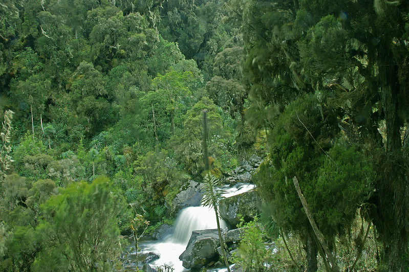
The forest accessed from the Kilembe trailhead is among the most intact montane forests remaining in the Albertine Rift, a biodiversity hotspot that the WWF and IUCN consistently rank among the world’s most important conservation areas. The lower forest sections of the Kilembe Trail have tree species assemblages that include Prunus africana, Strombosia, Symphonia, and Podocarpus, arranged in ways rarely seen outside a UNESCO World Heritage Site.
Rwenzori Forest Kilembe Trail


The epiphytic load on these trees, along with the ferns, orchids, mosses, and lichens colonizing every available surface, gives the forest a quality of accumulated life, of sheer biological abundance, that no photograph captures and that the experience of walking through it does something distinctive to the human nervous system.

Bugata Lake: A Glacial Jewel

The approach to Mutinda Lookout passes Bugata Lake, a glacially carved tarn set in a bowl of rock and moorland at approximately 3,430 meters. The lake is one of the Kilembe Trail’s defining features and one of its most photographed: dark water, still when the wind drops, surrounded by giant heather and lobelia, with the peak mass of the central Rwenzori providing a backdrop that belongs in a different era of the earth’s history. The camp at Bugata, the second night of this itinerary, sits above the lake’s eastern shore, with views across the water that change with every shift of light and cloud.

Mutinda Lookout: The Panorama That Earns Its Name

A lookout, in the Rwenzori context, is not a constructed viewing platform with a sign and a safety railing. It is a place where the mountain’s topography creates a natural opening in the ridgeline, an absence of obstruction that allows the landscape below and beyond to reveal itself in full. Mutinda Lookout, at approximately 3,597 meters, is exactly that: a rocky opening in the upper ridge of the Kilembe Valley from which, on a clear morning, the Rwenzori’s central peaks fill the northern skyline with a completeness that stops conversation. Your guide knows the hour at which clarity is most likely. The approach on summit morning is timed accordingly.

The Mubuku Falls

Among the features of the Kilembe Trail that distinguish it from the northern approaches is the Mubuku Falls, a multi-stage waterfall system encountered on the ascent through the upper forest and bamboo zone. In the primary season, the falls carry the full volume of the Rwenzori’s exceptional precipitation in a sustained, deafening cascade that is audible from thirty minutes below on the trail. In the shoulder seasons, the volume increases further, and the spray creates a permanent microclimate of cool, mist-saturated air around the falls zone. The light through this mist, in the right hour, produces rainbows of unusual intensity and duration.

What Makes the Mutinda Lookout Trek Special?

The Kilembe Forest — Africa’s Galapagos from the South

The forest entered from the Kilembe trailhead is some of the most intact montane forest remaining in the Albertine Rift — a biodiversity hotspot that the WWF and IUCN consistently rank among the world’s most important conservation areas. The lower forest sections of the Kilembe Trail pass through tree species assemblages that include Prunus africana, Strombosia, Symphonia, and Podocarpus in configurations rarely seen outside a UNESCO World Heritage Site. The epiphytic load on these trees — the ferns, orchids, mosses, and lichens colonising every available surface — gives the forest a quality of accumulated life, of sheer biological abundance, that no photograph captures and that the experience of walking through it does something distinctive to the human nervous system.

Bugata Lake — A Glacial Jewel

The approach to Mutinda Lookout passes Bugata Lake — a glacially carved tarn set in a bowl of rock and moorland at approximately 3,430 metres. The lake is one of the Kilembe Trail’s defining features and one of its most photographed: dark water, still when the wind drops, surrounded by giant heather and lobelia, with the peak mass of the central Rwenzori providing a backdrop that belongs in a different era of the earth’s history. The camp at Bugata — the second night of this itinerary — sits above the lake’s eastern shore, with views across the water that change with every shift of light and cloud.

Mutinda Lookout — The Panorama That Earns Its Name

A lookout, in the Rwenzori context, is not a constructed viewing platform with a sign and a safety railing. It is a place where the mountain’s topography creates a natural opening in the ridgeline — an absence of obstruction that allows the landscape below and beyond to reveal itself in full. Mutinda Lookout, at approximately 3,597 metres, is exactly this: a rocky opening in the upper ridge of the Kilembe valley from which, on a clear morning, the Rwenzori’s central peaks fill the northern skyline with a completeness that stops conversation. Your guide knows the hour at which clarity is most likely. The approach on summit morning is timed accordingly.

The Mubuku Falls

Among the features of the Kilembe Trail that distinguish it from the northern approaches is the Mubuku Falls — a multi-stage waterfall system encountered on the ascent through the upper forest and bamboo zone. In the primary season, the falls carry the full volume of the Rwenzori’s exceptional precipitation in a sustained, deafening cascade that is audible from thirty minutes below on the trail. In the shoulder seasons, the volume increases further and the spray creates a permanent micro-climate of cool, mist-saturated air around the falls zone. The light through this mist, in the right hour, produces rainbows of unusual intensity and duration.

CTA Banner Widget — Rwenzori Trekking Expeditions

Experience Rwenzori Beyond Expectations

Spots Filling Fast — Schedule Your Trek Today

Itinerary at a Glance

Day

Summary

Day 1

Arrival at Entebbe / Kampala → Private transfer to Kasese (5–6 hrs) → Pre-trek briefing → Overnight Kasese

Day 2

Kasese → Kilembe Trailhead → Trek to Sine Camp (~2,540m) → 5–6 hrs through montane forest

Day 3

Sine Camp → Bugata Lake Camp (~3,430m) → 5–7 hrs via Mubuku Falls, bamboo & upper moorland

Day 4

Bugata Lake Camp → Mutinda Lookout (~3,597m) → Loop descent → Kilembe Trailhead → Kasese → Return transfer

A 5-day extension is available that adds a full exploration day at Bugata Lake camp, allowing for acclimatization, a side excursion toward the upper moorland plateau, and a more leisurely summit morning approach to Mutinda Lookout. Contact us to discuss the version that best fits your schedule.

Detailed 4-Day Mutinda Lookout Trek — Day-by-Day Narrative

Day 1: Arrival — Transfer to Kasese — Pre-Trek Briefing

Your Rwenzori Trekking Expeditions representative greets you at Entebbe International Airport or your Kampala hotel and installs you in a private 4WD vehicle for the westward journey to Kasese. The road carries you through the full sweep of Uganda’s western geography: the equatorial suburbs giving way to red-earth farmland, then the expansive Katonga wetlands, then the broad plains of the western rift where the Rwenzori appears on the horizon, first as a rumor of elevation above the cloud line, then as the unmistakable dark mass of a mountain range generating its own weather. By the time you arrive in Kasese, the Rwenzori fills the western sky.

Kasese has an energy particular to gateway towns, the slightly compressed sense of a place that exists in relation to something larger than itself. Your guesthouse is comfortable and well-positioned, with en-suite rooms and a kitchen that understands the relationship between excellent food and restful sleep before a mountain begins. The pre-trek briefing takes place over dinner: your lead guide covers the Kilembe Trail’s character, the day-by-day terrain, the ecological context of each zone you will pass through, and the altitude management protocols that apply above 3,000 meters. Gear is checked and confirmed tonight. The morning will not wait for second thoughts.

Day 2: Kilembe Trailhead → Sine Camp (~2,540m) The Southern Forest

The short drive from Kasese to Kilembe, through the old mining quarter where the copper-extraction infrastructure still stands in various states of productive or decorative obsolescence, ends at the Kilembe Trailhead, where Uganda Wildlife Authority formalities are completed and your Bakonjo porter team assembles with the organized calm of a group that has done this trek in every season, more times than they can count.

The forest entered from the Kilembe side has a different quality from the northern approaches, being denser, darker, and, in the lower sections, more bamboo-rich than the Nyakalengija forest. The trail climbs steadily from the moment it leaves the trailhead, following the Kilembe River upstream through a canopy of Podocarpus, Strombosia, and giant Prunus africana; the bark of the path is dark with moisture, and the sound of the river is constant below. Colobus monkeys, both black-and-white and red colobus, are regularly encountered in the upper forest canopy in the first two hours of the trail, often at close range and in groups of twenty or more.

The birding in this section is exceptional. The African green broadbill, an Albertine Rift endemic and one of the most sought-after birds in East Africa, haunts the mid-canopy of this forest with a frequency that makes the Kilembe approach a genuine pilgrimage for dedicated birders. Rwenzori double-collared sunbird, Rwenzori turaco, and the striking Ruwenzori apalis are all reliably present between the trailhead and Sine Camp.

Sine Camp arrives in the late afternoon: a clearing in the heather above the dense forest line, with the valley floor visible below and the upper mountain invisible in its customary afternoon cloud above. Your cook has the camp running: tent pitched, fire lit, and dinner underway. The evening temperature at 2,540 meters is brisk and welcome after the humidity of the lower forest. Your guide’s evening briefing covers tomorrow’s longer, more demanding ascent to Bugata Lake and what the terrain above the bamboo line offers.

Guide Insight: “The lower Kilembe forest is the part of this trail that people are least prepared for; they expect the Rwenzori’s famous mud and altitude, but they don’t expect to be stopped in their tracks by an African green broadbill sitting at eye level in the bamboo, twenty meters away, for a full minute. That’s the Kilembe Trail. The wildlife doesn’t wait for you to be ready.” Lead Guide, Rwenzori Trekking Expeditions

Day 3: Sine Camp (~2,540m) → Bugata Lake Camp (~3,430m) — The Afro-Alpine Ascent

This is the day the Rwenzori’s most extraordinary landscape character asserts itself fully. The trail from Sine Camp pushes through the remaining bamboo zone in the first hour, dense, close-canopied, the light filtering through in moving columns before the bamboo gives way to giant heather, its gnarled trunks encased in meters of accumulated moss, its canopy opening progressively to reveal the upper mountain above. The Mubuku Falls appear at mid-morning: a multi-stage cascade of spectacular volume, the sound preceding the sight by several minutes, and the spray creating a microclimate of cool, hanging moisture around the falls zone.

Above the falls, the trail enters the Rwenzori’s Afro-alpine moorland, the landscape that makes this mountain range unlike anywhere else in Africa. Giant groundsel trees (Senecio adnivalis) stand five meters tall, their prehistoric rosette heads mounted on shaggy, moss-wrapped trunks. Giant lobelias (Lobelia wollastonii) erupt from the saturated peat in spires of pale flowers, their scale—two meters and above— providing a visual reference for the mountain’s biological extravagance. Between them, the trail winds through sphagnum moss gardens and tussock grass; the peat underfoot is deep enough to swallow a boot at an unwary step, and the silence, on cloud-free sections, is profound enough to hear individual water droplets falling from heather branches.


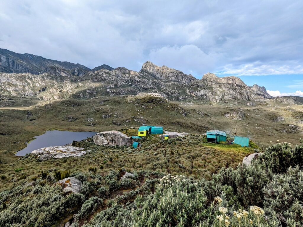
Bugata Lake appears at the head of the upper valley with the specific quality of arrival that only remote water has: suddenly, completely, without announcement. The tarn sits in a glacially carved bowl at approximately 3,430 meters, its dark water reflecting the sky and the ring of heather and rock that surrounds it. The camp above the eastern shore is positioned for the lake view in both the evening light and the morning. Giant lobelias stand sentinel at the water’s edge. If the cloud lifts in the hour before dark, as it sometimes does in the dry season, the peaks above the camp are briefly, spectacularly, visible in alpenglow. Dinner at Bugata camp, at altitude and in remote mountain air, achieves a quality of satisfaction that no restaurant has ever replicated in our experience.
Bugata Camp On Rwenzori Mountains -Kilembe Trail Route


Day 4: Bugata Lake Camp → Mutinda Lookout (~3,597m) → Loop Descent → Kilembe

The alarm sounds before first light at Bugata Lake camp, and the morning begins in darkness and cold, headlamps moving through the heather above the lake as the rope team assembles for the final ascent to Mutinda Lookout. The approach from Bugata takes approximately two hours on a trail that climbs steadily through the upper moorland, a landscape of rocky outcrops, cushion plant communities, and the occasional giant lobelia standing in silhouette against a sky that is lightening, incrementally, in the east.

Mutinda Lookout arrives with the sunrise. The rocky promontory opens the ridgeline to the north and east, and what it reveals, on a morning of any clarity whatsoever, is the Rwenzori’s central massif in full: the glaciated summits of Stanley, Speke, and Baker; the snowfields of the upper plateau; and below them, wave upon wave of moorland and forest valley descending toward the Ugandan plain. This panorama is the view that this trail exists to deliver. Your guide allows the time it deserves: photographs, the summit register, a flask of hot tea from the thermos that your porter carried up in darkness, and the particular quality of silence at a high viewpoint that has no road within several hours of it.

“Standing at Mutinda Lookout on a clear morning is one of the finest experiences the Rwenzori offers. The peaks are close enough to feel real — not distant, not abstract. You can see the ice. You can read the ridgelines. And you understand, for the first time, how large this mountain actually is.” — Senior Guide, Rwenzori Trekking Expeditions

The descent from Mutinda follows the loop’s return route, a different trail from the ascent, passing through terrain that includes high moorland, a transition through the bamboo and heather zone on the mountain’s alternative southern spur, and a final descent through lower forest back to the Kilembe Trailhead. The route covers more ground than the ascent and takes longer than the distances suggest; the Rwenzori’s terrain does not reward impatience, but it delivers a continuous sequence of new scenery and new botanical spectacle that makes every hour of the long day worthwhile.

By late afternoon, you reach the Kilembe Trailhead. Your dedicated vehicle awaits. The return to Kasese is a decompression, a transition from four days of mountain time back to the world of roads and schedules, and it carries the particular quality of a return from somewhere that has permanently adjusted something in your sense of what Africa is and what it contains.

How Difficult Is the 2-Day Rwenzori Trek to Sine Camp?

The 2-day Sine Camp Rwenzori trek via the Kilembe Trail is rated moderate, the most physically demanding of the accessible 48-hour Rwenzori trekking options, and a trek that requires honest preparation and genuine cardiovascular fitness. Understanding the nature of that difficulty, specifically where and why it occurs, allows for confident preparation.

Day 1: The Most Demanding Day

Day 1 covers 9.5 kilometers with 1,146 meters of elevation gain across seven to eight hours. The profile is deceptive: the first 2.2 kilometers to the UWA Ranger Post are genuinely easy, giving a false sense of what follows. The six kilometers through the forest core are a consistently moderate but unrelenting ascent, and the final two to three kilometers before Sine Camp steepen significantly, requiring a sustained push on a rooted, wet trail where adequate cardiovascular fitness is the primary requirement and trekking poles are the most valuable pieces of equipment in the pack. This day is not technically difficult; there is no climbing, no scrambling, and no exposed sections, but it is consistently aerobically demanding from the ranger post onward, and it is the day that determines whether this trek is a rewarding challenge or a survival exercise. Preparation makes that distinction.

Day 2: Technically Easier, Still Demanding

Day 2 is the same 9.5-kilometer trail in reverse, descending 1,146 meters over five to six hours. The descent is physically easier than the ascent from a cardiovascular perspective, but it demands sustained attention to footwork on the rooted and occasionally muddy trail surfaces, particularly on the steep upper section immediately below Sine Camp, where wet roots are the most common cause of slips and falls. Trekking poles are as important on the descent as on the ascent. Knee strength, which can be built through dedicated pre-trek training, determines how the descent feels in its final kilometers.

Technical Requirements & Altitude

There is no technical climbing on this trek. No glacier travel, no scrambling, no ropes, and no specialist equipment beyond trekking boots and trekking poles. The maximum altitude of 2,596 meters at Sine Camp is comfortably below the threshold where serious acute mountain sickness becomes a significant risk for healthy adults. Mild headache or reduced appetite on the Day 1 ascent is possible for some individuals and is a normal physiological response to the altitude gain rate. Informing your guide immediately of any symptoms and moderating your pace are the standard responses. A descent of 200–300 meters resolves symptoms rapidly if they progress.

Fitness Recommendation

Any adult who can complete a 12–15 kilometer day hike with 600–800 meters of elevation gain carrying a 10-kilogram daypack is a strong candidate for this trek. A four-to-six-week preparation program of three cardiovascular sessions per week, one longer weekend hike per week, and specific knee-strengthening exercises for the descent is strongly recommended. Trekkers over 50 with good aerobic health complete this route regularly and successfully; the key variables are consistent cardiovascular fitness and a willingness to set a pace that matches the terrain rather than the ambition.

CTA Banner Widget — Rwenzori Trekking Expeditions

Experience Rwenzori Beyond Expectations

Spots Filling Fast — Schedule Your Trek Today

Day-by-Day Altitude Profile


Day

Location

Altitude

Day 1

Kasese (overnight guesthouse)

~1,000m

Day 2

Kilembe Trailhead → Sine Camp

~1,500m → ~2,540m

Day 3

Sine Camp → Bugata Lake Camp

~2,540m → ~3,430m

Day 4

Bugata → Mutinda Lookout → Kilembe Trailhead

~3,430m → ~3,597m → ~1,500m

Route Comparison — Kilembe Trail vs Central Circuit Trail

Feature

Kilembe Trail — Mutinda Lookout

Central Circuit — John Matte Hut

Duration

4 Days

4 Days

Highest Point

Mutinda Lookout (~3,597m)

John Matte Hut (3,505m)

Route Style

Loop — different ascent and descent

Out-and-back on same trail

Approach Town

Kilembe (south)

Nyakalengija (north)

Trail Traffic

Low — more remote and less visited

Moderate — more established

Defining Feature

Panoramic summit views, Bugata Lake

Giant lobelia in the moorland, peak views

Forest Character

Dense southern montane, bamboo-rich

Podocarpus-dominant, moss forest

Best For

Trekkers seeking solitude & panoramas

Trekkers seeking Rwenzori history

Price Range

Moderate

Moderate

How Difficult Is the 4-Day Mutinda Lookout Trek?

The Kilembe Trail to Mutinda Lookout is rated moderate to challenging and demands a genuine level of fitness and mountain preparedness. It is not a technical trek; there is no glacier travel, no roped sections, and no crampons or ice axe required. But the trail terrain is consistently demanding: a rooted forest path, a deep peat bog in the upper moorland, stream crossings, and some rocky scrambles on the approach to Mutinda Lookout itself. The combination of altitude gain, daily trekking distances, and the Rwenzori’s characteristically wet underfoot conditions makes this a trek for people who are active, fit, and comfortable with sustained physical effort in mountain environments.

Day 3, from Sine Camp to Bugata Lake, is the most demanding of the trekking days: a sustained ascent of approximately 890 meters over five to seven hours on terrain that transitions from humid bamboo forest to cold, exposed moorland. Altitude begins to be a factor above 3,000 meters, and the final approach to Bugata Lake at 3,430 meters is felt in the lungs and the legs simultaneously. The summit morning on Day 4 begins before dawn at altitude, adding a cold and early start to the physical demands of the ascent. The return descent, though straightforward in terms of terrain, covers a significant distance and requires sustained attention on the lower forest sections.

Preparation recommendation: three months of dedicated cardiovascular fitness incorporating sustained uphill effort, load-bearing practice (a loaded day pack on hill walks), and some experience of multi-day trekking. Trekking poles are strongly recommended. Waterproof boots broken in before the trek are non-negotiable. Gaiters rated to knee height are essential for the upper moorland sections.

Category

Assessment

Overall Difficulty

Moderate to Challenging

Daily Trekking

5–7 hrs (Days 2–3); long day on Day 4 (~8–9 hrs)

Max Elevation

~3,597m — Mutinda Lookout

Total Altitude Gain

~2,100m over 2 ascending trekking days

Terrain

Forest, bamboo, bog moorland, rocky summit approach

Altitude Risk

Moderate, above 3,000m — AMS symptoms possible

Technical Sections

None — no glacier, no ropes, no crampons

Minimum Fitness

Good to excellent, structured prep strongly advised

Recommended Age

16+ (fit adults with no upper age limit)

Essential Equipment

Waterproof boots, knee-high gaiters, poles, warm layers

Best Time to Trek to Mutinda Lookout on the Kilembe Trail

Best Time to Trek to Mutinda Lookout on the Kilembe Trail

The Kilembe Trail shares the Rwenzori’s general seasonality, with rainfall throughout the year and relatively dry windows that offer more favorable trail conditions, but it has certain seasonal characteristics that are distinct from the northern approaches. The trail’s southern exposure means it catches more of the Congo Basin’s westerly weather systems in the shoulder seasons, while the primary dry season delivers some of the clearest summit views anywhere in the range.

Primary Season: June to August

The East African long dry season offers the Kilembe Trail’s most consistently navigable conditions. Trail mud, while never absent, is at its most manageable; the upper moorland between Sine and Bugata is crossable without extreme bog conditions; and the summit morning at Mutinda Lookout is most likely to deliver the panoramic clarity that makes this viewpoint exceptional. The sunrise view from Mutinda in July or August, with the glaciated peaks lit in the first light above a sea of clouds below, is one of the defining mountain experiences in East Africa. Book six to nine months in advance for this window.

Secondary Season: December to February

The short dry season provides a strong second window, with trail conditions approaching those of the primary season. The forest after the short rains is particularly alive, flowering, fragrant, and rich with bird activity, and January is one of the finest months for birding on the lower Kilembe forest sections. Christmas and New Year departures are popular and fill early; advance booking is equally important for this period.

Shoulder Seasons: March–May and September–November

The wetter shoulder seasons bring the Kilembe Trail’s most atmospheric and most challenging conditions simultaneously. The Mubuku Falls are at full, thundering volume. The moorland bog between Sine and Bugata is at its deepest and most character-building. The cloud sits low and persistent on Mutinda Lookout, making clear summit panoramas less likely, though brief windows of clarity do occur. For trekkers who want solitude, raw mountain atmosphere, and the particular satisfaction of earning every meter in genuinely wet conditions, the shoulder seasons are not without their appeal. We guide year-round and are always transparent about what any given month realistically offers.

How to Get to the Kilembe Trailhead

The Kilembe Trailhead is located approximately 10 kilometers east of Kasese town, at the end of the Kilembe Road that passes through the old mining complex. Kasese itself lies approximately 370 kilometers from Kampala and 420 kilometers from Entebbe, in the western rift valley at the foot of the Rwenzori Mountains.

By air, Entebbe International Airport (EBB) serves as the primary international gateway, with connections through Nairobi, Addis Ababa, Kigali, Dubai, Istanbul, and other hubs. Aerolink Uganda operates domestic flights between Entebbe and Kasese Airport (approximately one hour), subject to schedule availability. Rwenzori Trekking Expeditions privately arranges all airport transfers and road logistics. By road, the drive from Kampala or Entebbe to Kasese takes five to six hours in comfortable 4WD vehicles, following the Fort Portal highway west through some of Uganda’s finest equatorial scenery.

What Is Included in the 4-Day Mutinda Lookout Trek?

The Mutinda Lookout Trek is offered as a fully inclusive expedition. Every element of the journey is curated, arranged, and managed by Rwenzori Trekking Expeditions from the moment your representative greets you on arrival to the moment you are delivered back to your Kampala hotel or Entebbe Airport. You will not encounter any hidden charges, unexpected permit fees, or logistical gaps on the mountain.

Category

What Is Covered

Transfers

Private return transfers: Entebbe/Kampala ↔ Kasese ↔ Kilembe Trailhead

Park Fees & Permits

Uganda Wildlife Authority entry and trekking permits for all days

Guide Services

Certified lead guide throughout; assistant guides per group size

Porter Team

Full Bakonjo porter team for group and communal equipment

Accommodation

Sine Camp, Bugata Lake Camp (trekking nights), and Kasese guesthouse (Nights 1 & 4)

All Meals on Trek

Full board: breakfast, lunch, dinner, and hot drinks throughout

Emergency Equipment

First aid kit, pulse oximeter, supplemental oxygen, rescue coordination

Pre-Trek Briefing

Full route brief, equipment check, and altitude awareness in Kasese

Completion Cert.

Mutinda Lookout Trek completion certificate

Rescue Insurance

Mountain rescue insurance included in expedition fee

What Is Excluded?

Category

Notes

International Flights

Arrange independently via your preferred carrier

Uganda Visa

USD 50 on arrival or via e-visa. Go. ug in advance

Travel Insurance

Required: must include medical evacuation cover

Personal Porter

Available at additional cost: strongly recommended

Gratuities

For guides and porters: voluntary but culturally important

Alcoholic Beverages

Not provided at mountain camps

Personal Gear

Your personal trekking equipment (see packing list)

Pre/Post Accommodation

Kampala or Entebbe hotel nights before/after trek

Safari Extensions

Gorilla trekking, game drives — arranged separately on request

What Should I Pack for the Mutinda Lookout Trek?

The Kilembe Trail’s southern approach creates its own packing logic. The lower forest is warm and humid; the upper moorland at Bugata Lake is cold, exposed, and wet in any season; and the summit morning at Mutinda Lookout demands insulation layers that feel excessive at the trailhead. The only rational response to this range is to pack for all of it and manage layers actively throughout the trek. The Rwenzori does not reward the trekker who travels light at the expense of comfort; it rewards the trekker who is prepared for everything the mountain chooses to provide.

Item

Notes

Waterproof Boots

Ankle-support, fully waterproof, broken-in pre-trek—essential

Gaiters

Knee-length upper moorland mud requires maximum coverage

Waterproof Jacket

Full outer shell — Gore-Tex or equivalent

Waterproof Trousers

For upper moorland and cold summit morning

Base Layer

Moisture-wicking thermal top — merino wool preferred

Mid Layer

Fleece or down vest for Bugata Lake camp evenings

Insulation Layer

Heavy down jacket for summit morning (Mutinda predawn)

Trekking Poles

Adjustable, essential for bog crossing and summit approach

Sleeping Bag

-5°C rated minimum for Bugata Lake camp

Sleeping Liner

Adds warmth; keeps tent bedding clean

Headlamp

With spare batteries, mandatory for predawn summit start

Dry Bags

To protect electronics, sleeping kits, and clothing

Water Bottles

2 litres minimum; purification tablets as backup

Sunscreen

SPF 30+ — UV is significant above 3,000 m.

Binoculars

8×42: The Kilembe forest birding is exceptional

Personal First Aid

Blister care, personal medications, antihistamine

Camera

Waterproof case or dry bag because the Rwenzori is wet

Insect Repellent

DEET-based for lower forest sections

Warm Hat & Gloves

Essential for Bugata Lake camp and Mutinda summit morning

How Safe Is the 4-Day Mutinda Lookout Trek?

The Kilembe Trail to Mutinda Lookout presents no technical mountaineering hazards, no glacier travel, no exposed ridge sections requiring rope, and no crampons. Its primary safety considerations are the same as any high-altitude mountain trek: altitude sickness, wet and rooted trail terrain, and rapidly changing mountain weather. All three are managed through Rwenzori Trekking Expeditions’ operational protocols, which have been developed over years of year-round guiding on this trail.

All lead guides are Uganda Wildlife Authority certified and hold wilderness first aid qualifications. Every trekking party carries a comprehensive first aid kit, a pulse oximeter for blood oxygen monitoring above 3,000 meters, supplemental oxygen for altitude emergencies, and emergency communication equipment for rescue coordination with the Uganda Wildlife Authority and medical services. Mountain rescue insurance is included in the expedition fee for all clients.

The camp locations at Sine and Bugata Lake are well-established and weather-protected relative to the open ridgeline. The summit approach to Mutinda Lookout is on open moorland terrain; in severe weather, your guide will make the professional judgment to hold at Bugata and attempt the summit in a clearer window or adjust the return accordingly. Safety is the priority that precedes every other consideration on the mountain, and our guides are trained and authorized to make conservative decisions without hesitation.

Safety Element

Provision

Guide Certification

UWA-accredited; wilderness first aid trained

Medical Equipment

First aid kit, pulse oximeter, supplemental oxygen per group

Rescue Coordination

Emergency communication; mountain rescue insurance included

Altitude Monitoring

Blood oxygen tracked from Day 2 onward with an oximeter.

Weather Assessment

Daily assessment; summit timing adjusted for best conditions

Porter Welfare

Proper equipment, living wages, formal welfare policy

Emergency Protocol

Descent protocol activated at first serious AMS symptom

Pre-Trek Health Screen

All clients complete health disclosure before departure

CTA Banner Widget — Rwenzori Trekking Expeditions

Experience Rwenzori Beyond Expectations

Spots Filling Fast — Schedule Your Trek Today

Frequently Asked Questions

Mutinda Lookout is a natural rocky viewpoint at approximately 3,597 meters on the upper Kilembe Trail, positioned on the southern ridgeline of the Rwenzori Mountains. Its significance comes from its panoramic view to the north and east; on clear mornings, the view from Mutinda includes the glaciated central peaks of the Rwenzori (Stanley, Speke, and Baker massifs), the full sweep of the upper Kilembe valley, and, on exceptional days, the distant Ugandan plains. It is one of the finest non-glacier panoramic viewpoints on the entire Rwenzori range, accessible without technical mountaineering equipment, and the defining destination of the Kilembe Trail’s premier short expedition.

The two trails approach the Rwenzori from different directions: the Kilembe Trail from the south and the Central Circuit Trail from the north, delivering genuinely distinct experiences. The Kilembe Trail is less visited, offering greater solitude and more raw wildlife encounters in a bamboo-rich southern forest. Its loop structure means no terrain is repeated. The Mutinda Lookout provides a panoramic view of the central massif from a different angle than the Central Circuit’s northward-facing perspectives. The Central Circuit Trail, by contrast, follows the historic expedition route, reaches the Afro-alpine zone of the upper Bujuku valley, and is the staging route for the full Margherita Peak summit expedition. Both routes are exceptional; the choice depends on your preference for route style, solitude levels, and specific summit or viewpoint objectives.

The Kilembe Trail to Mutinda Lookout is best suited to trekkers with a good base fitness level and some experience of hiking on uneven terrain. It is more demanding than the 3-day Mahoma Loop (our recommended beginner route) but does not require the technical preparation of the summit expeditions. If you are new to mountain trekking, we recommend discussing your fitness and experience level with our team before committing to this itinerary. We can advise on preparation and, if appropriate, suggest starting with the shorter Mahoma Loop route as a Rwenzori introduction.

The Kilembe Trail is exceptional for wildlife; the lower southern forest, being less visited than the northern approaches, delivers wildlife encounters of a more raw and unpredictable quality. In the upper forest canopy, you can regularly see large groups of black-and-white colobus and red colobus monkeys. The African green broadbill, one of the most sought-after Albertine Rift endemics, is reliably present in the bamboo zone. L’Hoest’s monkey, Rwenzori turaco, various sunbird species, and multiple Albertine Rift endemic birds are all consistently sighted. The upper moorland above Sine Camp supports the three-horned Rwenzori chameleon, and observers occasionally spot clawless otters on the margins of Bugata Lake. The African leopard and giant forest hog are present but rarely seen.

Bugata Lake is a glacially carved tarn at approximately 3,430 meters on the upper Kilembe Trail, one of the defining features of the Mutinda Loop itinerary. The lake sits in a bowl of rock and moorland with the central Rwenzori peaks providing a backdrop on clear evenings, and its dark, still water is one of the most photographed features of the southern trail system. Swimming is possible, the water is cold (approximately 12°C–15°C) and clear, and at this altitude in a UNESCO World Heritage Site, the experience is genuinely extraordinary. At this altitude and in this type of lake, bilharzia is not a risk. The cold is substantial but not prohibitive for those who want to try.

Night temperatures at Bugata Lake Camp (approximately 3,430m) typically range between -2°C and 8°C, depending on season and cloud cover. The predawn summit start for Mutinda Lookout adds cold and darkness to the physical demands; temperatures at this hour can drop below -5°C in the dry season. A sleeping bag rated for a minimum of -5°C is required for comfort at Bugata. The descent day begins in these cold conditions and warms as you lose altitude through the forest. Proper layering, a heavyweight base, an insulating mid, and a waterproof outer are the essential strategies for the upper mountain section.

Altitude sickness (AMS) is a genuine consideration above 3,000 metres, and both Sine Camp (2,540 m) and Bugata Lake Camp (3,430 m) are within ranges where early symptoms, such as headache, reduced appetite, and disturbed sleep, can occur in susceptible individuals. Our guides carry pulse oximeters for continuous blood oxygen monitoring and supplemental oxygen for emergencies. The itinerary’s acclimatisation profile, which gains altitude progressively over Days 2 and 3 , is designed to minimise risk. Trekkers should hydrate consistently from Day 1, avoid alcohol above 2,500 metres, and consult their physician about Diamox (acetazolamide) before departure. Serious AMS above 3,000 metres is managed by immediate controlled descent.

Yes, the Kilembe Trail departs from Kasese, which is approximately three to four hours north of Bwindi Impenetrable National Park by road. The Mutinda Lookout Trek combines naturally with a gorilla trekking experience in Bwindi, making for a Uganda safari that encompasses both mountain trekking and primate conservation in a single coherent itinerary. Rwenzori Trekking Expeditions curates seamless combined Uganda expeditions covering the Rwenzori, Bwindi gorillas, Queen Elizabeth National Park game drives, and Kibale Forest chimpanzee tracking. Contact us to design your complete Uganda mountain and wildlife safari.

The Kilembe Trail uses tent-camp accommodation at Sine Camp and Bugata Lake Camp, well-positioned, weatherproof tent setups managed by our camp team, with communal cooking and dining shelters, basic long-drop toilet facilities, and stream water for washing. The porter team carries the camp equipment: tents, sleeping mats, and cooking infrastructure. Trekkers should bring their sleeping bags and personal items. Pre- and post-trek nights in Kasese are in comfortable guesthouse accommodation with en-suite rooms and hot showers. The mountain camps are functional and deliberately simple; the simplicity is part of the experience of genuine mountain wilderness.

Some trekking experience is strongly recommended for the Mutinda Lookout route. Day 3 (Sine to Bugata Lake) involves a sustained altitude gain of approximately 890 meters over five to seven hours on demanding terrain, and Day 4 involves an early predawn start followed by a long descent. Trekkers who have completed multi-day hill walks or hiking holidays will find the route very manageable with adequate preparation. Those with no experience of sustained uphill effort should consider the 3-day Mahoma Loop first or consult our team about a structured preparation program before committing to Mutinda.

Three things set the Kilembe Trail apart from the northern approaches: its loop structure (which means no terrain is repeated), its southern forest character (bamboo-rich, less visited, with more raw wildlife encounters), and the specific panoramic quality of Mutinda Lookout (which faces north toward the central massif rather than looking up at it from within). The combination of these three factors creates a trekking experience that is, in character and in the specific visual and ecological details it delivers, categorically distinct from the Central Circuit experience, which means that trekkers who have completed the northern routes perceive the Kilembe approach as the Kilembe approach genuinely new rather than merely different.

The expedition fee covers all private transfers, Uganda Wildlife Authority permits, a certified guide and porter team, tent camp accommodation, full board meals, emergency equipment, and mountain rescue insurance. Pricing varies by group size, season, and any customizations or extensions. We provide full, transparent pricing with no hidden fees within 24 hours of inquiry. Contact us at trek@rwenzoritrekkingexpeditions.com for a personalized quote.

Both Sine Camp and Bugata Lake Camp are equipped with basic long-drop toilet facilities and stream water for washing. The camp infrastructure is functional rather than luxurious — the setting is a mountain wilderness experience, and the simplicity of the camps is consistent with and appropriate to that character. Biodegradable soap is carried in our group supplies. Full hot shower facilities are available at the Kasese guesthouse on nights 1 and 4. The mountain camps are comfortable within the context of high-altitude camping; trekkers who require hotel-standard amenities on the mountain should be aware that these are not available on any Rwenzori route.

Three months of structured preparation is our standard recommendation for the Mutinda Lookout route. The preparation program should include sustained cardiovascular training (running, cycling, or swimming for 45–60 minutes, four to five days per week), load-bearing hill walks with a 10–15 kg pack on progressively longer and steeper routes, and at least two or three overnight multi-day hikes in the month before departure. Specific attention should be given to strengthening the knees and ankles; the long Day 4 descent covers significant elevation loss on terrain that demands joint stability. We provide all confirmed clients with a detailed preparation program on request.

Three months of structured preparation is our standard recommendation for the Mutinda Lookout route. The preparation program should include sustained cardiovascular training (running, cycling, or swimming for 45–60 minutes, four to five days per week), load-bearing hill walks with a 10–15 kg pack on progressively longer and steeper routes, and at least two or three overnight multi-day hikes in the month before departure. We should pay specific attention to strengthening the knees and ankles, as the long Day 4 descent covers significant elevation loss on terrain that demands joint stability. We share a detailed preparation program with all confirmed clients on request.

Every Rwenzori Trekking Expeditions itinerary is adaptable. The four-day Mutinda Lookout Rwenzori trek can be extended to five days with an additional rest and exploration day at Bugata Lake, offering acclimatization time and the opportunity for side excursions into the upper moorland plateau. The route can also be combined with pre- or post-trek extensions to Bwindi Impenetrable National Park, Queen Elizabeth National Park, Kibale Forest, or Kampala cultural experiences. Private group departures on any date are available. Contact our team to discuss the configuration that fits your group, your schedule, and your vision of the experience.

All lead guides with Rwenzori Trekking Expeditions speak fluent English and Rutooro, the regional language of western Uganda. Most also speak Lhukonjo, the language of the Bakonjo porter community. Several senior guides speak French and conversational Swahili. For groups with non-English speakers, please advise us at the time of booking so we can accommodate them with guide assignment or supplementary interpretation where possible.

Why Book Your Rwenzori Trek With Rwenzori Trekking Expeditions?

The Kilembe Trail is not a route that rewards casual arrangements. Its remoteness, its demanding terrain, and its exceptional wildlife and ecological richness all require a guide who knows it the way a musician knows a piece they have played hundreds of times, not from reading but from repeated, intimate experience in every season and every condition the mountain provides.

Rwenzori Trekking Expeditions has that knowledge. We have guided the Kilembe Trail year-round, in sunshine and in the most dramatic Rwenzori weather, with trekkers of every fitness level and every level of mountain experience.

We are a Ugandan-owned specialist operator with one focus: the Rwenzori Mountains. Our guides are UWA certified and wilderness first aid trained. We pay our Bakonjo porter team living wages, equip them properly, and support them through the only formal porter welfare policy operated by any Rwenzori trekking expeditions. Our approach to each booking is personal, a conversation rather than a transaction, with a member of our team who has stood at Mutinda Lookout and knows what is waiting for you there.

Every permit, every porter load, every meal, every camp location, and every safety protocol is arranged and managed by a team that knows this trail the way the Bakonjo know the mountain. Your only task is to arrive fit, curious, and ready to be somewhere extraordinary.

When you book with Rwenzori Trekking Expeditions, you are not purchasing a packaged product. You are commissioning an experience from specialists who will design it with you to be exactly right for your group. That is the standard we hold ourselves to, and it is the standard this mountain deserves.

CTA Banner Widget — Rwenzori Trekking Expeditions

Experience Rwenzori Beyond Expectations

Spots Filling Fast — Schedule Your Trek Today

Book Your 4-Day Mutinda Lookout Trek Today

The Rwenzori’s southern slopes are waiting. Bogotá Lake, at 3,430 meters, is waiting. Mutinda Lookout, with its unobstructed view of Africa’s third-highest peak system, is waiting. And the Kilembe Trail, less visited, more remote, and arguably more beautiful than any other four-day route in this mountain range, is a finite experience in a world where wild places of this caliber are becoming rarer with every passing year.

The glaciers visible from Mutinda Lookout on a clear morning are retreating. The Rwenzori’s ice fields, which have endured since the Pleistocene, may largely disappear by the end of this decade. The mountain itself, its forests, its moorland, and its extraordinary Afro-alpine ecosystems will remain. But the specific combination of wilderness, ice, and panorama that defines this viewpoint is a combination that has a window. If this page has spoken to you, that window is now open.

Scroll to Top