6 Days Hunwick's Camp Trek - Rwenzori Trekking Service
The 6-Day Rwenzori Trekking to Hunwick’s Camp navigates the Montane Forest, ascends through the Bamboo Zone, advances into the Heather Zone, and traverses the Alpine Zone to arrive at Bugata Camp at an altitude of 4,062 meters. From this juncture, ascend and navigate Bamwanjara Pass at 4,450 meters, then descending into the notable Kacholpe Valley, distinguished by its unique dense vegetation and abundant Scarlet-Tufted Malachite Sunbirds.
The biodiversity in Kacholpe Valley is rich in flora, mosses, and wildlife. Hunwick’s Camp, located at an altitude of 3,974 meters, rests at the foothills of Mt. Stanley and Mt. Baker, which is often covered in snow. The subsequent day, you ascend sharply to Olivers Pass, necessitating a 40-minute climb to the summit of Weismann’s Peak, where, on a clear day, one can view all the notable peaks of the Rwenzori range.
After Weismann’s Peak, you swiftly descend the Nyamwamba Valley, experiencing several scenic waterfalls before returning to Base Camp.
A Detailed 6-Day Hunwick’s Camp Rwenzori Trekking Itinerary
Day 1
Begin from Trekkers, located at 1,450 meters, then ascend to Sine Hut at 2,596 meters, yielding a height increase of 1,146 meters. Alternatively, persons in excellent physical condition may choose to proceed to Kalalama Camp at 3,134 meters, which not only presents breathtaking views but also affords extra time at Mutinda Camp, where one can ascend to Mutinda Lookout at 3,975 meters.
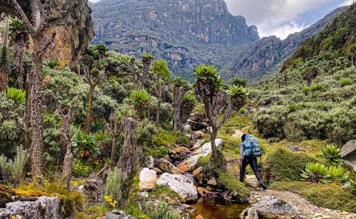
We begin by navigating the valley bottom among the towering trees of the Afro-Montane Forest Zone. This is a steady incline with several species of birds and the potential to witness blue monkeys traversing the forest. Visitors may occasionally witness groups of 15 to 20 black and white Colobus monkeys traversing the treetops. Infrequent observations of the L’Hoest monkey, essential to Bukonzo heritage, are protected under the jurisdiction of the King or Omusinga, although distant calls of wild chimpanzees may also be audible. A vast assortment of plant species is present, encompassing forest trees, bamboo thickets, low shrubs, flowers, mushrooms, and various moss and lichen-covered vines cascading from the towering trees, creating a visually spectacular aesthetic. Enock’s Falls are situated within 200 meters of Sine Hut, offering an exceptional opportunity to capture a stunning screensaver for your memories.
Sine Camp, located at an altitude of 2,596 meters, features wooden cabins nestled among tall forest trees on a narrow ridge, enabling guests to admire the beauty of the Afro Montane forest and the stunning waterfall falling over the rocks below. Some clients prefer to sit outside, enjoying the warmth of the campfire while discussing the mountains and their shared lifestyle with the guides. Sine is situated just below the bamboo zone, and the vicinity is home to a rich range of avian species. Enock Falls, situated 150 meters from the camp, is enveloped by lush green vegetation and flowing vines. Exceptionally elegant. Individuals recuperating at Sine, or those physically able who opt to proceed to Kalalama Camp at 3,134 meters, may do so. This alternative provides breathtaking views and permits extra time in Mutinda Camp, where one can ascend to Mutinda Lookout at 3,975 meters.
Day 2
The expedition begins at 8:30 AM, proceeding right into the Bamboo-Mimulopsis Zone, noted for its steep elevation with several elevated steps. The bamboo area gets very muddy and slick during the wet season, which causes delays. The atmosphere and the forest are remarkable as you climb 551 meters over 1.8 kilometers to Kalalama Camp at 3,147 meters, located in the Heather-Rapanea Zone, where you may take a short break and savor a cup of tea or coffee before continuing to Mutinda Camp. The path meanders over numerous minor hills along a ridge, lowers into the valley, ascends again, crosses multiple small streams, and nears moss-laden waterfalls.
You ascend gently beside a scenic moss-laden river that tumbles over rocks beneath the towering Giant Heather trees, whose trunks are embellished with green moss and Usnea lichen hanging from the branches. The trail meanders as you climb the deep valley, which features a diverse range of vegetation and flowers. This valley is unique, featuring several Giant Heather plants that provide a scenic atmosphere often shrouded in mist.
In the afternoon, you may wish to ascend to the summit of Mutinda Lookout, which takes approximately one to two hours to ascend and one hour to descend. The views are magnificent as you stand atop moss-laden rocks at an altitude of 3,925 meters, overlooking the Rwenzori Mountains, the town of Kasese, and Lake George. Clients hiking Margherita or any of the primary peaks will discover that climbing Mutinda, at 3,975 meters, is an efficient means of acclimatization and reducing the risk of high altitude sickness.
Located at Mutinda Camp at an altitude of 3,582 meters.
Day 3
The route to Bugata Camp is boggy, particularly in the wet season; nevertheless, with little skill, one can navigate from tussock to tussock for improved speed. Commence by traversing the Mutinda Valley, distinguished by tussock grass and everlasting flowers, interspersed with numerous Giant Lobelias, before ascending a challenging section to the Namusangi Valley (3,840 meters), where precipitous waterfalls are prevalent, providing breathtaking vistas of the Mutinda Peaks from the rear. The Namusangi Valley is vast, with multiple elevations as the route steadily ascends to Bugata Camp at 4,100 meters.
Day 4
Trek to Hunwick’s Camp via Bamwanjarra Pass. Upon leaving Bugata Camp, you traverse a ridge, subsequently fall somewhat before ascending to Bamwanjarra Pass at 4,450 meters, where an emergency hut is accessible in the event of adverse weather conditions. On a clear day, the pass provides remarkable vistas of the three notable snow-covered summits. The trek navigates the valley, bypassing bogs and dense coniferous vegetation, featuring thick mosses, large groundsel, and lobelia, evoking an ancient ecosystem.
This spot is undoubtedly the foremost area in the Rwenzori for seeing the Malachite Sunbird as it forages on various lobelia flowers and functions as a recognized breeding habitat.

Subsequently, there are precipitous segments succeeded by a steady climb over a ridge to Hunwick’s Camp, situated above a profound valley, offering superb sights of Mt. Stanley, Mt. Baker, Weismann’s Peak, and McConnell’s Prong.
Day 5
The distance to Kiharo Camp is 11 kilometers, with a walking length of 4 to 9 hours depending on individual fitness levels.
We begin the day at Hunwick’s Camp by climbing a ridge toward McConnell’s Prong, which provides the best views of all three peaks and Scott Elliott’s Pass, before reaching Oliver’s Pass at an altitude of 4,505 metres. The distance from Hunwick’s Camp to the top of Olivers Pass is 3 km. The path subsequently passes beneath Weismann’s Peak to the confluence of the Nyamwamba River, which flows via Kilembe and Kasese to Lake George in Queen Elizabeth National Park.
Ascending Weismanns Peak, which rises to 4,620 meters from Olivers Pass, is allowed and necessitates roughly 40 minutes for a round trip ascent. On a clear day, one can witness spectacular views of Margherita, Mt Stanley, Mt Speke, and Mt Baker.
Upon crossing the confluence, the path drops into the valley leading to Kiharo Camp, situated in a deep ravine marked by steep rocks and verdant vegetation. Upon descending the valley, following each bog, you will navigate a ridge of stones and soil that seems odd, yet was deposited by glaciers that gradually advanced, then halted their movement, melted, and left a mound of rocks and debris at the endpoint of their former existence.
Day 6
The distance from Kiharo Camp to the park gate is 16 km, and a further 2.8 km to Trekkers Hostel. Individuals needing to connect to flights returning to Kampala or attending other commitments must leave Kiharo early, as the trek requires 5 to 8 hours of trekking.
The path that leads through the Nyamwamba Valley is primarily downhill and exceptionally scenic, showcasing stunning views, moss-covered rocks by the river, cascading waterfalls, and deep gorges and forests that are undoubtedly the most magnificent in the Rwenzori Mountains. This segment of the route necessitated six years to ascertain a traversable way appropriate for travelers. In 1937, the explorer and geologist McConnell endeavored to traverse this valley but was unsuccessful and had to withdraw in pursuit of an alternative route up the mountain; however, this very spectacular valley can now be enjoyed.
A few kilometers before Kiharo Camp, the path veers to the right, paralleling the river. In the open areas, one may watch a Duiker stealthily foraging in small clearings while navigating the riverside. This site probably contains the largest population of Rwenzori Red Duikers in the National Park. Several kilometers downstream, the river becomes more precipitous, including numerous stunning waterfalls. After the waterfalls, we climb a steep incline and drop into the dense forest, providing stunning views of the valley below. We pause at Forest View Camp for lunch before returning to Base Camp. A remarkable event and culmination of an unbelievable journey.
Conclusion of the 6-Day Rwenzori Trek to Hunwick’s Camp