8 Days Rwenzori Trek To Cheptegei Peak at 4907m
The 8 day Rwenzori trek to Cheptegei Peak (4,907m) in Rwenzori Mountains is a demanding yet gratifying Rwenzori mountaineering safari, traversing the Kilembe Trail and culminating in an ascent of the Stanley Plateau. The expedition entails traversing many ecosystems, including woods, bamboo groves, and alpine meadows, with the summit attempt on the sixth day characterized by snowy, rocky, and difficult conditions. The itinerary generally has stops at Sine Camp, Mutinda Camp, and Margherita Camp prior to the ultimate ascent and descent.
An 8-day Rwenzori Trek to Cheptegei Peak (4,907m) expedition entails trekking varied ecosystems, such as forests, bamboo groves, and alpine meadows, ending in a demanding ascent via the demanding terrain and ice of the Stanley Plateau.
Kindly be advised: You may ascend Mt. Baker provided you are in good physical condition. The ascent of Baker is short although demanding, offering significant rewards, especially on clear days when one can appreciate the breathtaking vistas of Mt. Stanley, Margherita Peak, and the glaciers; alternatively, one may choose to ascend Weismann’s during the descent.
Mount Stanley ranks as the third highest peak in Africa; nevertheless, the genuine appeal lies in the ascent via the Kilembe Trail(southern circuit), distinguished by forests and valleys that exhibit a diverse spectrum of flora, including trees and ferns. The trees abound with diverse bird and primate species; as you progress down the trail, you may notice chimpanzee nests nestled in the lofty branches, and if fortunate, you can glimpse the resident chimps as they retreat.
The ascent to Cheptegei Peak is non-technical and does not necessitate substantial rock scrambling, permitting a rope-free climb; nonetheless, for safety considerations, we carry ropes for this excursion.

The peak provides breathtaking panoramas over the valleys on both the Ugandan and Congolese sides, as well as striking views of Alexandra Peak, Margherita Peak in the distance, and the Stanley Glaciers beneath. The strategy for ascending the peaks parallels that of Margherita Peak, with the only exception being our avoidance of Margherita Glacier; instead, we will traverse Stanley Glacier prior to mounting Cheptegei Peak at 4907 meters.
The 8-day Rwenzori Trek to Cheptegei Peak (4,907m) expedition entails trekking varied ecosystems, such as forests, bamboo groves, and alpine meadows, ending in a demanding ascent via the perilous terrain and ice of the Stanley Plateau.
Kindly be advised: You may ascend Mt. Baker provided you are in good physical condition. The ascent of Baker is short although demanding, offering significant rewards, especially on clear days when one can appreciate the breathtaking vistas of Mt. Stanley, Margherita Peak, and the glaciers; alternatively, one may choose to ascend Weismann’s during the descent.
An In depth 8-Day Rwenzori Trekking Itinerary to Cheptegei Peak
Day 1 Of the 8 Days Rwenzori Trek To Cheptegei
Begin at Trekkers, located at 1,450 meters, and spend the night in Sine Hut at 2,596 meters, achieving an elevation gain of 1,146 meters. Alternatively, individuals in excellent physical condition may choose to proceed to Kalalama Camp at 3,134 meters, which provides breathtaking views and permits extended time in Mutinda Camp, where one can ascend to Mutinda Lookout at 3,975 meters.
We begin our rise through the valley floor, maneuvering around the tall trees of the Afro Montane Forest Zone. This is a steady incline with several avian species and the potential to witness blue monkeys traversing the forest. Visitors may occasionally witness groups of 15 to 20 black and white Colobus monkeys navigating the treetops. Infrequent observations of the L’Hoest monkey, a cultural emblem of the Bukonzo, are safeguarded by the jurisdiction of the King or Omusinga, and one may also perceive the distant calls of wild chimpanzees. A rich assortment of plant species is present, including forest trees, bamboo thickets, low shrubs, flowers, mushrooms, and various moss- and lichen-adorned vines descending from the towering trees, creating a striking visual appeal. Enock’s Falls are situated within 200 meters of Sine Hut, offering an exceptional opportunity to capture a fantastic screensaver for your memories.
Sine Camp, located at an altitude of 2,596 meters, features wooden cabins nestled among towering trees on a small ridge, enabling guests to see the beauty of the Afro Montane forest and overlook a stunning waterfall tumbling over the rocks below. Some clients prefer to sit outdoors, enjoying the warmth of the campfire while discussing the mountains and their communal life with the guides. Sine is situated directly below the bamboo zone, and the adjacent region hosts a varied assortment of species of birds. Enock Falls, situated 150 meters from the camp, is enveloped by lush vegetation and flowing vines. Extremely elegant. Individuals at Sine, especially those in optimal physical condition, may choose to ascend to Kalalama Camp at an altitude of 3,134 meters. This route provides stunning views and permits extra time in Mutinda Camp, where one can climb to Mutinda Lookout at 3,975 meters.
Day 2:
day 2 of the 8 Days Rwenzori To Trek Cheptegei Peak at 4907m via Kilembe trail begins at 8:30 AM, proceeding right into the Bamboo-Mimulopsis Zone, distinguished by a steep slope with several elevated steps. In the rainy season, the bamboo area becomes exceedingly muddy and slippery, causing work to be delayed. The atmosphere and the forest are remarkable as you climb 551 meters over 1.8 kilometers to Kalalama Camp at 3,147 meters, located in the Heather-Rapanea Zone, where you may take a short break and savor a cup of tea or coffee before continuing to Mutinda Camp. The path meanders over numerous minor hills along a ridge, lowers into the valley, ascends again, crosses multiple small streams, and nears moss-laden waterfalls.

You then ascend gently beside a scenic moss-laden river that tumbles over the rocks beneath the towering Heather trees, whose trunks are embellished with green moss and festooned with Usnea lichen. The trail meanders as you climb the steep valley, rich with a diverse assortment of vegetation and flowers. This valley is unique, featuring several Giant Heather plants that provide a scenic atmosphere often shrouded in mist.
In the afternoon, you may wish to ascend to the summit of Mutinda Lookout, which takes approximately one to two hours to ascend and one hour to descend. The panoramas are breathtaking when you stand atop moss-laden rocks at an altitude of 3,925 meters, surveying the Rwenzori Mountains and gazing down at Kasese town and Lake George. Clients ascending to Margherita or any of the key peaks will discover that climbing Mutinda, at 3,975 meters, is an efficient means of acclimatization and reducing the risk of high altitude sickness.
Sleep at Mutinda Camp at an altitude of 3,582 meters.
The ascent to Cheptegei Peak is non-technical and does not necessitate substantial rock scrambling, permitting a rope-free climb; nonetheless, for safety considerations, we carry ropes for this excursion.
Day 3:
The route to Bugata Camp is boggy, particularly in the rainy season; nevertheless, with little skill, one can traverse by stepping from tussock to tussock to aid movement. Commence by traversing the Mutinda Valley, distinguished by tussock grass and everlasting flowers, interspersed with numerous Giant Lobelias, before ascending a steep gradient to the Namusangi Valley (3,840 meters), where dramatic waterfalls are prevalent and the views of the Mutinda Peaks are breathtaking from the rear. The Namusangi Valley is vast, featuring multiple elevations as the route steadily rises to Bugata Camp at 4,100 meters.
Day 4:
Trek to Hunwick’s Camp via Bamwanjarra Pass. Upon leaving Bugata Camp, you navigate a ridge, drop slightly, and then ascend to Bamwanjarra Pass at 4,450 meters, where a cabin is provided for adverse weather conditions. On a clear day, the pass provides magnificent views of the three primary peaks. The path crosses the valley, bordering the edges of wetlands and thick coniferous vegetation, comprising moss, large groundsel, and lobelia. This spot may be the foremost area in the Rwenzori for watching the Malachite Sunbird since it forages on various lobelia flowers and is acknowledged as a nesting ground. Subsequently, there are precipitous segments succeeded by a steady elevation across a ridge to Hunwick’s Camp, situated atop a profound valley, offering superb vistas of Mt. Stanley, Mt. Baker, Weismann’s Peak, and McConnell’s Prong.
Day 5
From Hunwick’s, we descend and traverse the valley floor to Lake Kitendara, notable for its deep waters and splendid flora. From this juncture, ascend Scott Elliott’s pass and go up the ridge to Margherita Camp, situated at an altitude of 4,485 meters, amidst considerable boulders that offer some shelter from the intense winds. This is the exact site where the Duke of Abruzzi set up his camp during his 1906 ascent of Margherita Peak.
Kindly take note:
On this day, You have the option to summit Mt. Baker, if you are in perfect physical condition. The ascent to Mount Baker is concise yet demanding, yielding significant rewards, especially on a clear day, as it provides remarkable views of Mt. Stanley, Margherita Peak, and the glaciers.
Day 6
Partake in an early breakfast this morning; we shall be ready to trek between 4:30 and 5:30 AM, with the precise departure time dependent on the vigor and speed of the trekkers.
We ascend from the starting point of the Stanley Glacier to its midpoint, then turn left and go until we arrive at the terminal of the Stanley Glacier on the cliffs. The rocks are situated directly below the Stanley viewpoint, and navigating from Glacier Point to the rocks at the base of the viewpoint takes 20 to 30 minutes. We will proceed with a brief rock scramble to the viewpoint, which, while not overly demanding, necessitates approximately 30 to 40 minutes due to the low oxygen levels throughout the ascent; still, it is an enjoyable climb.
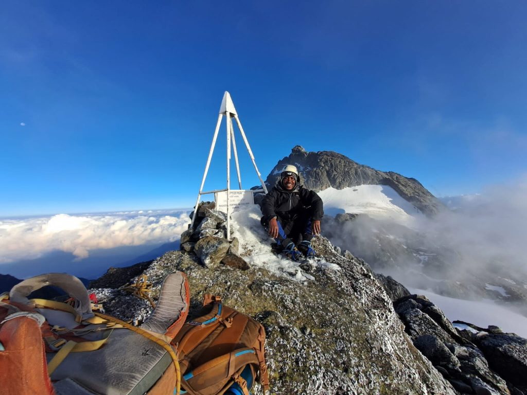
At an elevation of 4907 meters, the summit of Cheptegei Peak offers views of parts of Alexandra, other cities in the Congolese region, as well as panoramas of Mt. Speke, Bujuku Valley, the Portal mountains, multiple peaks of Elena, and a lake in Congo.
The peak is non-technical and does not necessitate rock scrambling, permitting ascent without ropes; nonetheless, for safety considerations, we carry ropes for this climb.
Upon attaining the peak at 4,905 meters, you then drop down to Hunwick’s Camp at 3,874 meters.
Elevation gain: 422 meters, succeeded by a decline of 933 meters
Expected distance: 2 km rise succeeded by a 7.1 km descent
Expected duration: 4 to 6 hours to reach the summit and return to Margherita Camp, and 3 to 4 hours to Hunwicks Camp.
Day 7:
Distance to Kiharo Camp: 11 kilometers The time required for walking varies from 4 to 7 hours.
We begin the day at Hunwick’s Camp by climbing a ridge toward McConnell’s Prong, which provides the most exquisite views of all three peaks and Scott Elliott’s Pass, before reaching Oliver’s Pass at an altitude of 4,505 meters. The distance from Hunwick’s Camp to the peak of Olivers Pass is 3 km. The path subsequently crosses beneath Weismann’s Peak to the confluence of the Nyamwamba River, which flows via Kilembe and Kasese to Lake George in Queen Elizabeth National Park.
To ascend Weismanns Peak, which rises to 4,620 meters from Olivers Pass, an extra cost of $20 per individual is mandated. On a clear day, one can witness spectacular views of Margherita, Mt Stanley, Mt Speke, and Mt Baker.
The path descends into the valley towards Kiharo Camp, situated in a deep ravine marked by steep rocks and dense vegetation. Upon descending the valley, following each bog, you will navigate a ridge of stones and soil that seems illogical, yet was deposited by gradually approaching glaciers that eventually halted their advance, melted, and left a mound of boulders and debris at the glacier’s old location.
Day 8
The distance from Kiharo Camp to the park gate is 16 km, followed by a further 2.8 km to Trekkers Hostel. Individuals requiring connections to flights back to Kampala or proceeding to other engagements must depart from Kiharo early, as the journey necessitates 5 to 8 hours of walking.
The descent through the Nyamwamba Valley is predominantly downhill and remarkably picturesque, featuring exquisite vistas, moss-laden rocks adjacent to the river, flowing waterfalls, profound gorges, and trees that may be unparalleled in the Rwenzori Mountains. This segment of the path required six years to provide a navigable route suitable for travelers. In 1937, the explorer and geologist McConnell attempted to navigate this valley but was unsuccessful and had to retreat in search of an alternative route up the mountain; nonetheless, you can now enjoy this remarkably magnificent valley.
A few kilometers from Kiharo Camp, the trail diverges to the right to follow the river. In the open areas, one may observe a Duiker discreetly foraging in small clearings while traversing the riverbank. This location likely harbors the highest population of Rwenzori Red Duikers within the National Park. A few kilometers downstream, the river steepens and features numerous breathtaking waterfalls. Following the waterfalls, we ascend a steep slope and descend into the deep trees, offering breathtaking vistas of the valley beneath. We halt at Forest View Camp for lunch prior to returning to Base Camp. An exceptional experience and conclusion to an outstanding adventure.