A dual ascent of Mount Karisimbi in Rwanda and Margherita Peak on Mount Stanley in the Rwenzori Mountains of Uganda is one of the most ambitious and varied hiking trips in East Africa. These are two of Africa’s most captivating high-altitude goals, distanced by several hundred kilometers of equatorial terrain yet connected by remarkable biodiversity, physical challenges, and the sheer improbability of reaching glaciated peaks in such proximity to the equator.
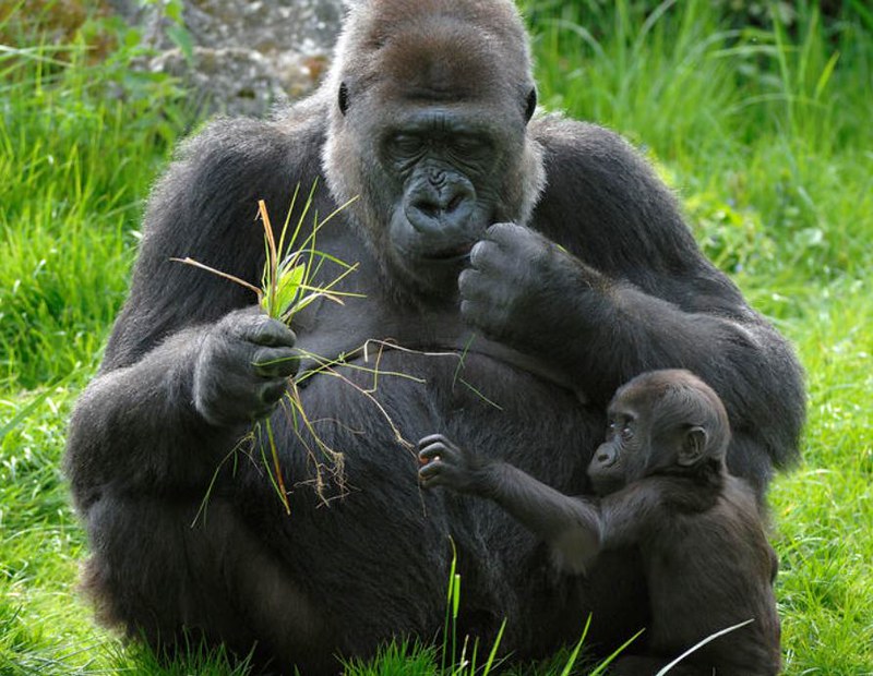
Mount Karisimbi, standing at 4,507 meters, is the tallest summit in Rwanda and the highest among the eight Virunga volcanoes. It is located on the boundary between Rwanda and the Democratic Republic of Congo inside Volcanoes National Park, which also protects the endangered mountain gorilla populations renowned through Dian Fossey’s study at the Karisoke Institute.
A 2-day guided Karisimbi hike via bamboo forest, hagenia-hypericum forest with gigantic lobelias, and open Afroalpine moorland culminates in a summit with 360-degree vistas of the Virunga range, representing one of the premier hiking expeditions in central Africa.
The Rwenzori Mountains, often known as the Mountains of the Moon, are Uganda’s UNESCO World Heritage alpine range, located around 400 kilometers to the northeast. Margherita Peak on Mount Stanley, at 5,109 meters, is the highest Peak, the third-highest point in Africa, and one of the few remaining equatorial glaciated peaks on the continent.
The normal 8-day Kilembe Trail Rwenzori Trekking adventure traverses from the historic copper-mining village of Kilembe through five distinct vegetation zones and over the Stanley Plateau Glacier to a mountain that rises 600 meters above Karisimbi, necessitating both physical conditioning and glacier navigation skills.
This 14-day Rwenzori & Mount Karisimbi trekking expedition encompasses arrival in Kigali, ascent of Karisimbi, entry into Uganda with an optional gorilla trekking experience at Bwindi Impenetrable Forest National Park, and completion of the entire Kilembe Trail to Margherita Peak, representing one of the premier dual-summit trekking experiences in East Africa. Rwenzori Trekking Expedition orchestrates and oversees the Uganda segment via a unique collaboration with Rwenzori Trekking Services, ensuring that the logistical transition between the two mountain programs is efficient.
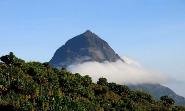
Mount Karisimbi (4,507 m), the Volcanic Peak of Rwanda.
Mount Karisimbi is a dormant stratovolcano, rising 4,507 meters above sea level, located on the Rwanda-DRC border within Volcanoes National Park. It is the tallest of the eight Virunga volcanoes, surpassing Mount Bisoke, Muhabura, Sabinyo, and the other peaks in this remarkable volcanic range, and ranks as the 11th highest mountain in Africa. The name derives from the Kinyarwanda term “amasimbi,” which translates to “white shell” or “snow,” alluding to the frost and sporadic snowfall that adorn its top during cooler months.
The typical ascent of Karisimbi requires two days, beginning at the Volcanoes National Park headquarters in Kinigi, adjacent to Musanze in northern Rwanda. On the first day, the trek begins near the park boundary, approximately 2,600 meters above sea level, across a dense bamboo forest. A brief diversion leads to Dian Fossey’s graveyard at the Karisoke Research Center, followed by an ascent through hagenia-hypericum woods and expansive moorland adorned with huge lobelias and senecio plants. Upon completing around six to eight hours of ascent, you reach the overnight mountain camp at 3,700 meters, where tents and rudimentary amenities are provided beneath some of the most star-studded skies in central Africa. Day two commences before to dawn, generally with a 5:30 AM awakening for the final ascent to the summit. The final hour is steep, rugged, and elevated, yet does not necessitate technical climbing expertise. On a clear day, the summit offers a panoramic view of the entire Virunga range: to the east lies Bisoke’s crater lake, to the west the smoking cone of Nyiragongo across the Congolese border, and to the south the undulating green hills of Rwanda’s thousand hills.
The permit for hiking Karisimbi is priced at $400 per individual, encompassing the guide, overnight stay on the mountain, and all associated park taxes. The permit is organized via the Rwanda Development Board and is managed as an element of this integrated adventure package.
Margherita Peak, Mount Stanley (5,109 m), the pinnacle of the Rwenzori.
Margherita Peak atop Mount Stanley, at 5,109 meters, is the highest elevation in Uganda, the highest in the Democratic Republic of Congo, and the third-highest peak in Africa. It is located in the equatorial Rwenzori range, characterized as a block mountain created by ancient tectonic uplift rather than volcanic activity. The glaciers above its highest ridges are among the final equatorial glaciers in Africa, fast diminishing owing to climate change, yet they remain, captivating and necessitating authentic glacier trekking skills to attain the summit.
The Kilembe Trail, operated solely by Rwenzori Trekking Services and accessible through Rwenzori Trekking expeditions, offers an 8-day complete circuit originating from Kilembe town in Kasese, western Uganda. In contrast to Karisimbi, which necessitates minimal technical climbing, Margherita entails the use of crampons, ice axes, and coordinated roped movement on the Stanley Plateau Glacier. The Uganda Wildlife Authority has constructed a new glacier bridge and secured climbing lines on the essential crevasse section, enhancing safety and accessibility for guided groups. The route traverses five distinct vegetation zones, culminating in a departure from Margherita Camp (4,485 m) at 2:30 AM for the pre-dawn ascent to the summit. The summit experience, standing on Africa’s third-highest peak on a glaciated top near the equator, is undeniably one of the most significant mountaineering accomplishments accessible to non-technical climbers.
The contrast between the two summits contributes to the allure of this joint excursion. Karisimbi is a precipitous, exposed volcano characterized by rapidly fluctuating weather and uncomplicated navigation beyond the treeline. The Rwenzori summit is a glacier ascent on a block mountain, technically more challenging and necessitating specialized summit gear, however it is approached through a landscape of remarkable botanical and ecological intricacy that Karisimbi does not emulate. Collectively, they present both aspects of Africa’s high-altitude realm.
A Detailed 14 Days Rwenzori and Karisimbi Trekking Expedition (Day-by-Day)
Day 1: Kigali – Transfer to Musanze/Volcanoes National Park
Your journey starts at Kigali International Airport, a pristine and efficient gateway to Rwanda, esteemed as one of the premier airports in sub-Saharan Africa. Upon completing immigration procedures and retrieving your bags, your Rwanda adventure guide will greet you in the arrivals area for the two-and-a-half to three-hour journey northwest to Musanze, the main town in northern Rwanda and the access point to Volcanoes National Park. The road traverses Rwanda’s renowned thousand hills, where terraced agricultural slopes descend into valleys shrouded in morning mist, until the volcanic cones of the Virunga range emerge on the northern horizon.
Musanze is a pleasant town with a variety of lodging alternatives, including economical guesthouses, mid-range lodges, and upscale accommodations with direct views of the volcanoes. Your team registers, recuperates after the journey, and participates in an evening briefing regarding the Karisimbi hike: permit issuance, equipment inspection, wake-up schedule, and anticipated conditions on the mountain for the subsequent two days. The evening is spent at an elevation; Musanze is situated at approximately 1,900 meters, marking the initial gradual phase in the acclimatization process that the excursion is structured around.
Overnight stay at Five Volcanoes Boutique Hotel.
Day 2: Mount Karisimbi – Bamboo Forest to High Mountain Camp (3700m)
The wake-up time is early. Following breakfast, the journey from your accommodation to the Volcanoes National Park headquarters in Kinigi for briefing and registration is succeeded by an additional drive to the commencement of the Karisimbi route at the park boundary, approximately 2,600 meters above sea level, at the base of the volcanic forest. Your Rwandan guide team will consist of a lead ranger-guide, porters responsible for transporting camping equipment, food, and sleeping gear, along with your own daypack with water, waterproof clothing, and snacks.
The initial hours of the hike traverse a thick bamboo woodland, where long, verdant stalks click overhead in the slightest breeze, diffusing the light into a gentle, mellow glow. This region is inhabited by mountain gorillas, and although a sighting along the Karisimbi trail is not assured, evidence of gorilla presence, including as fresh nests, broken bamboo, and faeces, is observable across the lower slopes. Dian Fossey’s grave at the Karisoke Research Centre is situated roughly 45 minutes from the trail junction; the optional diversion extends the journey by an hour but is highly rewarding for those interested in the history of gorilla conservation.
Above the bamboo, the flora shifts to hagenia-hypericum woods, characterized by greater height and openness, including gnarled moss-laden trees and beams of light penetrating the forest floor. The slope becomes very steep. By mid-afternoon, the forest transitions into an expansive Afroalpine moorland, where towering lobelias exceed head height, and vistas unfold in all directions. The camp at 3,700 meters is attained after six to eight hours of trekking: a rudimentary yet operational tent camp featuring a mess tent, pre-prepared meals, and sleeping bags. Temperatures decrease significantly at high altitudes after sunset. The twilight sky at 3,700 meters on the Virunga mountain, devoid of light pollution, is remarkable.
Elevation: 1,800 m to 3,700 m
Emphasis: Stamina and acclimatization to elevation
Overnight camping
Day 3: Summit of Karisimbi and Descent to Musanze
Awaken at 5:30 AM. The last ascent to the peak commences in near-darkness, with headlamps illuminating the rugged, volcanic trail ahead. The last part from camp to peak is the steepest and most difficult of the entire Karisimbi ascent, as altitude and gradient converge to render movement sluggish. The speed established by your guides is intentional: a gradual approach ensures safety at high altitudes, allowing you ample energy reserves for the extended descent.
At an elevation of 4,507 meters above sea level, you are positioned at Rwanda’s highest peak. The complete Virunga range encompasses your surroundings: Bisoke, featuring its perfectly circular crater lake to the east; the still-active Nyiragongo in the DRC to the west, frequently shrouded by its own emissions; Muhabura, Sabinyo, and the other Virunga peaks positioned to the east and north; and the undulating green highlands of Rwanda extending southward to the distant horizon. The temperature at the top can climb severe; wind, frost, and mist are prevalent even during the dry season. However, the feeling of standing on this volcanic peak, aware that the Rwenzori and a second, higher summit lie ahead in the coming days, imparts a unique intensity to the occasion.
The descent from the top to Musanze requires around six hours. By sunset, you return to your lodge, enjoying a hot shower, a warm meal, and the tranquil satisfaction of having conquered the first great summit. Rest is crucial this evening; tomorrow marks a travel day, and the subsequent eight days in the Rwenzori will require your utmost effort.
Elevation: 3,700m → 4,507m → 2,300m
Focus: Acclimatization and recovery
Overnight stay at Five Volcanoes Boutique Hotel.
Day 4: Transfer to Bwindi Impenetrable National Park
The journey from Musanze in Rwanda to Kasese in western Uganda traverses some of the most visually striking landscapes in East Africa. The two primary routing possibilities are contingent upon the prior acquisition of a gorilla trekking permit at Bwindi Impenetrable Forest, a premier wildlife experience on the continent, which, due to the geographical rationale of the route, necessitates merely one or two additional days.
If gorilla trekking is part of the itinerary, the journey proceeds southwest to Kabale in southwestern Uganda, thereafter ascending into Bwindi Impenetrable Forest National Park, which harbors over fifty percent of the global population of mountain gorillas throughout its four sectors: Buhoma, Ruhija, Rushaga, and Nkuringo. An afternoon arrival permits rest and recovery, a briefing for the subsequent morning’s gorilla permit activities, and the opportunity to immerse oneself in the remarkable nature environment of Bwindi. Gorilla trekking permits in Uganda are roughly $800 per individual and require ahead booking. The one-hour interaction with a habituated gorilla family in the dense forest profoundly alters your perception of animal intellect and wilderness.
In the absence of gorilla trekking, the direct journey from Musanze to Kasese requires approximately six to seven hours, utilizing the border crossings at Katuna/Gatuna or Cyanika/Bunagana. This route traverses the Ankole highlands of southwestern Uganda before descending into the Kasese basin, where the snow-capped ridgeline of the Rwenzori mountains is visible to the northwest. Routing either reaches the Kilembe base or the Kasese lodging in anticipation of the mountain expedition.
Day 5: Kilembe, Briefing | 14 Days Rwenzori & Mount Karisimbi Trekking
Today marks the crossover between the two mountain programs. Upon your direct arrival from Rwanda the preceding afternoon, Day 5 serves as a day for rest, acclimatization, and logistical arrangements at Kilembe base camp. If the gorilla trekking add-on was selected, you will drive from Bwindi to Kasese/Kilembe today, a three-to-four-hour drive through the Rwenzori foothills, with the mountain becoming increasingly prominent with each km.
The Rwenzori Trekking Services crew at the Kilembe trail base provides a thorough expedition briefing, including the 8 days Rwenzori trekking Itinerary, altitude management techniques, weather forecasts, summit day prerequisites, and equipment inspection. All technical climbing equipment, including crampons, ice axes, helmets, harnesses, ropes, and rubber boots, is distributed and meticulously inspected here. The guiding crew comprises a lead professional mountain guide, an assistant guide, and a porter team sourced from the Bakonjo community, the indigenous inhabitants of the Rwenzori foothills, whose connection to the mountain has endured for generations. A final inspection of sleeping bags, rain gear, and layering systems is performed, and any deficiencies in equipment are rectified.
Evening meal at the base, an early retirement, and the awareness that the ascent of the Rwenzori commences before dawn.
Overnight at Kilembe Base Camp
Day 6: Kilembe Trailhead to Sine Camp
The Kilembe Trail commences at an elevation of 1,450 metres, which is lower than Musanze and several hundred metres beneath beginning point of the Karisimbi Trail. Following two days atop a volcano and a journey through two nations, there is a deep sense of fulfillment in beginning afresh at the base, amidst the warmth of the Rwenzori’s lower forest. The comparison with the volcanic Virunga terrain is instantaneous and complete: while the lower slopes of Karisimbi were densely populated with bamboo and comparatively open, the Rwenzori’s Afro-Montane Forest is primordial, stratified, and intricate, resembling a cathedral of Podocarpus and Prunus africana adorned with climbing plant life and resonating with bird melodies.
The hike ascends consistently for five to six hours through progressively verdant and moss-covered woodland, traversing the Mubuku River via log bridges and maneuvering through root-laden segments that need cautious footing. Blue monkeys and black-and-white colobus traverse the elevated canopy. Three-horned chameleons, resembling prehistoric creatures and exhibiting extreme lethargy, reside in the understory. Merely 200 meters prior to Sine Hut, Enock’s Falls cascades down a moss-clad cliff face under a veil of white water. Sine Camp, situated at 2,596 meters, marks your inaugural night in the Rwenzori: cooler than the valley, quieter than any location you have encountered in days, accompanied by the sound of flowing water from all directions.
Elevation: 1,450 m to 2,596 m
Overnight: Sine Camp
Day 7: From Sine Camp to Mutinda Camp via Kalama
The second day in the Rwenzori immerses you in the mountain’s most extraordinary flora region. The bamboo-mimulopsis stretch commences shortly after departing Sine; it is steep and elevated, and during the wet season, it is covered in treacherous mud that necessitates complete focus. Above the bamboo, the expansive heather forest dominates, resulting in the Rwenzori’s distinctive botanical signature, a landscape that compels even seasoned mountain trekkers to pause and observe: tree heathers reaching fifteen meters in height, enveloped in layers of old man’s beard lichen (Usnea) and various species of mountain moss, their trunks contorted into remarkable forms by decades of ice pressure.
Kalalama Camp, situated at an elevation of 3,147 meters, serves as a midday stopover offering vistas of the valley below. The trail ascends through more dense heather and moss forests, traversing minor rivers and waterfalls, before reaching Mutinda Camp at an elevation of 3,588 meters. In the afternoon, an optional hike to Mutinda Lookout at 3,975 meters is available, entailing a two-hour round trek, to appreciate a comprehensive vista over southern Rwenzori, Kasese, and Lake George. Following two days on Karisimbi, the altitude of Mutinda is well-known, and the acclimatization advantages of the observation trek are tangible.
Elevation: 2,596m to 3,588m
Overnight in Mutinda Camp.
Day 8: From Mutinda Camp to Bugata Camp
On the eighth day of the combined adventure and the third day on the Kilembe Trail, you enter the alpine zone unequivocally. The path traverses the expansive Mutinda Valley, characterized by wide moorland interspersed with everlasting flowers and the renowned gigantic lobelia of Rwenzori (Lobelia wollastonii), whose tall floral spikes ascend to five meters above the adjacent flora. The Namusangi Valley segment, at an elevation of 3,840 meters, showcases vertical waterfalls observable from the trail and, when viewed in reverse, the diminishing pyramid of Mutinda Peak, bordered by the valley’s walls.
Bugata Camp, situated at an elevation of 4,062 meters, exceeds four kilometers for the first time in the Rwenzori range. The elevation at Bugata surpasses that of the Karisimbi summit, and the altitude presents more severe conditions; wind, cold, and diminished light at high elevations all contribute to a distinct mountain experience. Your acclimatization from the Karisimbi ascent is advantageous; most hikers who have completed Karisimbi find Bugata’s altitude rather bearable. Prioritize early sleep, adequate water consumption, and a warm supper as the evening’s recommendations.
Elevation: 3,588 m to 4,062 m
Overnight in Bugata Camp.
Day 9: Bugata Camp to Hunwick’s Camp via Bamwanjara Pass
This is the day the Rwenzori unveils its most remarkable spectacular vista. The ascent from Bugata to Bamwanjara Pass, at an elevation of 4,450 meters—surpassing the summit of Karisimbi and any previous altitude attained during this expedition—culminates on a ridge that reveals the three majestic peaks of the Rwenzori: the ice-clad massif of Mount Stanley, with Margherita obscured in its upper echelons; the dark pyramid of Mount Baker to the west; and the silhouette of Weismann’s Peak positioned between them. An emergency shelter is located at the pass; in adverse weather conditions, it offers temporary sanctuary while the guide makes a descent decision.
Hunwick’s Camp, located at an elevation of 3,974 meters, overlooks a broad valley, offering views of Stanley, Baker, Weismann’s Peak, and McConnell’s Prong above. A little, audacious group of Malachite Sunbirds resides among the towering lobelia around the camp, their iridescent feathers contrasting vividly with the grey-green moorland. This is among the premier camping locations in the Rwenzori, and after the difficult Bamwanjara traverse, reaching this site seems like arriving at the perfect destination.
Elevation: 4,062m → 4,450m → 3,974m
Overnight: Hunwick’s Camp.
Day 10: From Hunwick’s Camp to Margherita Camp
The route to the final staging camp prior to the summit is intentionally brief in distance yet considerable in elevation. The trek descends from Hunwick’s to across the valley floor, passing Lake Kitandara, a profound glacial lake whose dark, tranquil surface and verdant surrounding flora create one of the most evocative moments of the entire Kilembe Trail. The lake is located at the base of the Stanley massif, and gazing upward from its beach towards the glaciated ridgeline serves as a clear reminder of the demands of the forthcoming morning.
The route ascends from Kitandara, across Scott Elliott’s Pass and proceeding up the ridge to Margherita Camp, situated at an elevation of 4,485 meters. The site is situated amidst large boulders that offer natural wind protection. In 1906, the Duke of Abruzzi encamped at this identical site following the inaugural ascent of Margherita. The afternoon is allocated for rest, equipment inspection, and the summit briefing: departure at 2:30 AM, crampons must be donned prior to the glacier, and a mandatory turnaround at 10:00 AM irrespective of location. Maintain a nutritious diet, retire early, and have confidence in your preparedness.
Elevation: 3,974 m to 4,485 m
Overnight: Margherita Camp.
Day 11: Summit Day: Margherita Peak and Descent to Hunwick’s Camp
Awaken at 2:00 AM. Departure scheduled for 2:30 AM. The darkness is absolute, with your headlamp beam as the sole illumination on the ice ahead. The Stanley Plateau Glacier necessitates the use of crampons and ice axes from this juncture, and the guide secures the team with ropes.
The gradient intensifies as one traverses the plateau towards the base of the Margherita Glacier, the most demanding technical segment of the ascent, featuring inclines that may attain 60° and crevasse dangers that the Uganda Wildlife Authority’s newly established fixed lines assist in navigating securely. The climb from camp to Margherita Peak often requires four to five hours.
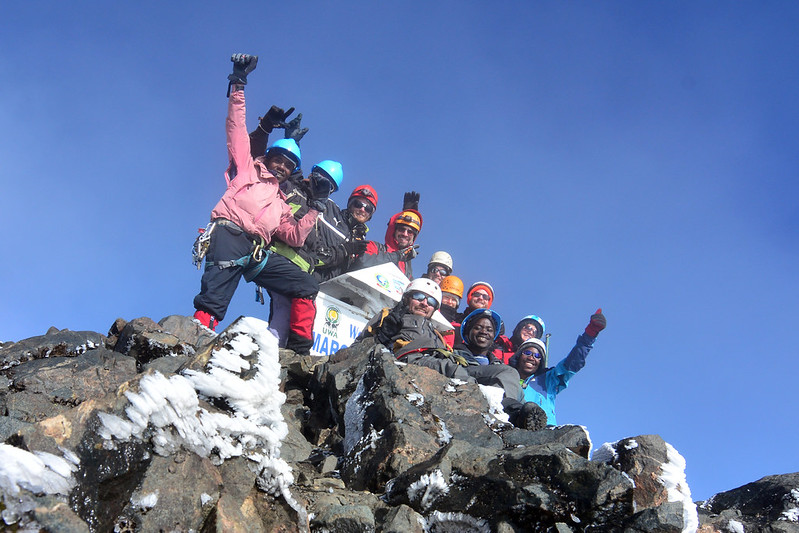
At the peak, which stands at 5,109 meters, you are positioned 602 meters above the Karisimbi summit attained previously in this excursion. You are situated at Africa’s third-highest elevation. The Congo basin extends westward beneath an uninterrupted verdant canopy. The Rwenzori range extends both northward and southward. On a clear morning, the horizon in all directions reveals solely the sky, mountains, and the Earth’s bent surface underneath you. This location represents the pinnacle of a joint expedition that has traversed two nations, navigating tropical forests, volcanic moorlands, bamboo regions, heather forests, Afroalpine meadows, and two glaciated summits. Your guide possesses a legitimately obtained certificate.
The individual from the top descends to Margherita Camp and subsequently proceeds to Hunwick’s Camp at 3,874 meters. The complete summit day from Margherita Camp to Hunwick’s generally lasts 10 to twelve hours. This is the most challenging and memorable day of the joint trek.
Elevation: 4,485m → 5,109m → 3,874m
Overnight: Hunwick’s Camp
Day 12: From Hunwick’s Camp to Kiharo Camp (34.60m) via Oliver’s Pass (4505m)
The Kilembe Trail’s descent is one of its most significant attributes, featuring an exceptional wilderness quality that remains mostly unexplored by the trekking community. From Hunwick’s Camp, the trail ascends a ridge towards McConnell’s Prong before reaching Oliver’s Pass at 4,505 meters, the highest pass traversed during the entire trip, surpassing Bamwanjara Pass and situated 2 meters below the summit of Karisimbi. The vistas of the Three Peaks and Scott Elliott’s Pass from Oliver’s Pass provide a comprehensive overview of the mountain prior to the descent.
The descent via the Nyamwamba Valley, a trail of secluded, serene beauty that follows the river system from its glacial source to its junction with the Kilembe River, whose waters continue downstream through Kasese and eventually reach Lake George in Queen Elizabeth National Park. The path traverses historic moraines, bogs, and dense heather forests before reaching Kiharo Camp at 3,460 meters, a secluded valley campground encircled by cliffs, with Kiharo Falls, a magnificent cascade located within 200 meters from the camp, audible throughout the night.
Elevation: 3,874m → 4,505m → 3,460m
Overnight at Kiharo Camp
Day 13: Kiharo Camp to Kilembe Trailhead and Transfer to Kasese
The last 16 kilometers of trails descend the Nyamwamba Valley, traversing some of the most affluent wildlife habitats along the entire journey. Rwenzori red duikers are often observed in forest clearings, while the remarkable cascades beneath Kiharo resonate through the valley as the river increases in gradient and volume. The path ascends short to an elevated ridge offering expansive valley vistas before descending through thick forest to Forest View Camp for lunch, subsequently continuing below to the Kilembe park entrance.
At the gate, you produce your Rwenzori Trekking Services certificate, a testament to one of the most legitimately acquired credentials in East African climbing, marking the formal conclusion of an excursion that has traversed two nations and two mountain ranges. A 4×4 safari car from Rwenzori Trekking Expeditions transports the entire group back to Kasese for the first hot shower and comfortable bed.
Elevation: 3,460 m to 1,450 m
Overnight at Kilembe Base Camp.
Day 14: Kasese to Entebbe International Airport
The final day is designated for transfers. The journey from Kasese to Entebbe International Airport takes around five to six hours via Fort Portal and the Kampala-Masaka highway, or four hours to Queen Elizabeth National Park for those embarking on a wildlife safari.
The route east from Kasese traverses the entire southern slope of the Rwenzori range, the very mountain you have just explored for eight days. Observing it from the valley floor after ascending its highest ridges offers a viewpoint that no photograph can sufficiently convey. The expedition concludes at the airport.
Two peaks. Two nations. A journey that merits the designation.
Why This Expedition Is Unique: The Argument in Favor of the Dual-Summit Combination
Numerous operators provide Rwenzori trekking and others Karisimbi hiking. The combination is exceedingly rare due to the necessity of coordinating two distinct mountain management systems across two nations, accompanied by a complicated logistical network connecting them. The amalgamation exceeds the mere total of its components due to factors that extend beyond mere geography.
Karisimbi and the Rwenzori exemplify two distinct categories of African high mountains: one is volcanic and expansive, characterized by swift alterations in flora and the enduring influence of Dian Fossey’s gorilla conservation efforts; the other is a tectonic block mountain, richly vegetated, ancient in a different context, and crowned by one of Africa’s last equatorial glaciers. The disparity in geology, ecology, and characteristics between the two ranges renders the joint trip a more comprehensive representation of East African mountain systems than either could offer independently.
The argument for acclimatization is also persuasive. Two days on Karisimbi at an altitude of 4,507 meters establish a robust physiological basis for the greater challenges posed by Rwenzori. Trekkers who ascend Karisimbi initially reach the Kilembe Trail with their bodies acclimatized to prolonged exertion at high altitudes, their equipment thoroughly vetted in mountainous environments, and their psychological assurance in their high-altitude capabilities firmly established. The change from the Virunga volcanic habitat to the Rwenzori forest ecosystem enhances each consecutive day in the latter range, as these two mountainous environments are markedly distinct, despite both being designated by UNESCO.
The Optional Gorilla Trekking Extension in Bwindi Impenetrable Forest
For trekkers with sufficient time and resources, the strategic location of Bwindi Impenetrable Forest between the Virunga range and the Rwenzori renders it a rational inclusion in this adventure. Bwindi, located in southwestern Uganda, harbors over fifty percent of the global population of mountain gorillas, with 500 individuals distributed among four hiking sectors. A permit-required one-hour interaction with a habituated gorilla family in the impenetrable forest is consistently regarded as the most profound wildlife experience in Africa.
Incorporating one or two nights at Bwindi between the descent from Karisimbi and the arrival in Kasese prolongs the adventure by one to two days and introduces a distinctly different aspect to the journey: transitioning from volcanic highlands to lush lowland forests, from peak to canopy, and from mountain glaciers to gorilla families. The comparison emphasizes the uniqueness of this region in Africa: the concentration of remarkable experiences inside a limited geographical space. Gorilla trekking permits in Uganda are presently priced at around $800 per individual and need ahead booking. Rwenzori Trekking Expedition manages the complete logistics of the Bwindi extension under the combined adventure package.
Physical Conditioning, Training, and Readiness for the Joint Expedition.
The joint Karisimbi-Rwenzori trek is a significant endeavor that necessitates authentic physical preparation. You will go on a twelve-day trip at elevations between 1,450 and 5,109 meters, encountering weather conditions that may consist of chilly rain, wind, mist, and subzero temperatures at high camps. The summit day on Margherita entails glacier navigation, which imposes greater technical requirements than those needed for Karisimbi.
Trekkers must be capable of walking continuously for six to nine hours over steep, uneven terrain while carrying a daypack weighing eight to twelve kilograms for a minimum of five consecutive days. Previous multi-day trekking experience is highly advisable, not due to the intricacy of navigation (as your guides manage all route-finding), but because comprehending your body’s response to prolonged daily exertion over several days is invaluable for effectively managing pace, nutrition, and recovery in the mountainous environment. A systematic training regimen commencing eight to twelve weeks prior to departure, which includes consistent hill walking, stair climbing, or jogging, constitutes the minimum preparation need.
Altitude sickness constitutes the principal hazard on both summits. The expedition’s acclimatization protocol is meticulously planned to mitigate this risk, commencing at a moderate elevation in Rwanda, increasing to 4,507 meters over two days, followed by a down and further ascent along the Kilembe Trail’s thoughtfully constructed altitude ladder. Prior to travel, consult your physician on the use of Diamox (acetazolamide) for altitude prophylaxis. Our guides are proficient at recognizing altitude sickness and are equipped with supplemental oxygen. The 10:00 AM turnaround rule on Margherita summit day is crucial and directly impacts safety.
Essential Kit for the Combined Expedition
Preparing for a 14-day dual-summit adventure across two mountain ranges necessitates meticulous planning. The fundamental approach remains consistent across both mountains: layering, waterproofing, and investing in quality footwear. The circumstances on Karisimbi and the Rwenzori differ; the Virunga’s volcanic landscape is steeper and more exposed, whereas the Rwenzori’s forested areas are more protected and wetter, however the essential equipment requirements largely coincide.
Your base layer must be synthetic or made of merino wool; avoid cotton, as it retains moisture and diminishes warmth when damp. A significant mid-layer fleece, a completely waterproof hardshell jacket with sealed seams, and a down or synthetic insulated jacket for camping and summit activities are all indispensable. For the lower body, waterproof trail trousers or softshell trousers paired with waterproof over-trousers are effective for both mountains. Waterproof, ankle-supporting boots that have been adequately broken in prior to the excursion are essential; blisters and boot malfunction at high altitudes have terminated more expeditions than adverse weather or physical fitness. Trekking poles mitigate knee strain and enhance stability during steep descents on both mountains, particularly on wet root and rock segments.
For the Margherita summit, a sleeping bag rated to a minimum of minus ten degrees Celsius for the Rwenzori high camps, a down or heavy synthetic insulated jacket for the glacier, warm gloves, a balaclava, and sunglasses to mitigate glacier glare are all required. Rwenzori Trekking Services supplies crampons, ice axes, helmets, and harnesses at the Kilembe trailhead; personal equipment is unnecessary. For Karisimbi, the identical sleeping bag and insulation are necessary for the 3,700-meter campsite overnight; the summit day is freezing but does not necessitate advanced glacial gear.
Optimal Timing for the Joint Expedition
The dry seasons of both mountains are synchronized, facilitating the preparation of this joint excursion. The principal dry season, from June to August, is optimal for both Karisimbi and the Rwenzori, with reduced precipitation, more stable paths, enhanced visibility at high altitudes, and the greatest summit success rates on Margherita. This month is the main booking season for gorilla trekking at Bwindi; therefore, it is advisable to get Bwindi permits well in advance if a gorilla extension is intended.
The secondary dry window, from late December to February, represents the second most favorable choice. The conditions in December and January on both summits are often dependable, and this period circumvents the peak-season crowds of July and August while still providing outstanding summit opportunities. Celebrating Christmas and New Year on the Rwenzori glacier is an exceptionally remarkable experience for individuals whose family schedules let it.
The wet seasons of April-May and October-November render both mountains considerably more challenging. The routes of Karisimbi become exceedingly muddy, and its top is often concealed by clouds; the forested areas of the Rwenzori present the greatest challenges, with river crossings necessitating meticulous oversight. Rwenzori Trekking Expeditions accommodates experienced trekkers year-round, but first-time high-altitude trekkers are highly encouraged to aim for the dry season windows.
What’s Included in the Package Fees
Professional, licensed mountain guide for the full 7 days
Rwanda Development Board hiking permit
Licensed Uganda Wildlife Authority ranger guide
Dedicated porter team, personal gear and camp supplies
All meals (breakfast, lunch, dinner, hot drinks)
All accommodation
Complimentary use of rubber boots (Rwenzori essential)
National Park entry fees and climbing permits
Summit achievement certificate upon completion
Emergency first aid kit and oxygen on mountain
Pre-trek equipment and safety briefing
Not Included in the Package Fees:
International flights and Uganda entry visa
Transfers to/from Nyakalengija trailhead (available on request)
Personal trekking gear: sleeping bag, jacket, hiking boots, poles
Warm and waterproof clothing (essential; see packing list)
Medical evacuation and travel insurance (required)
Personal expenses and snacks on the mountain
Tips and gratuities for guides and porters (encouraged)
Alcoholic beverages
Any costs arising from itinerary changes due to weather or medical reasons